Planet satellite imagery has started to reveal the events that killed 70 people at in northern India. It clearly indicates that intense rainfall triggered landslides that transitioned into channelised debris flows.

On 5 August 2025, a series of terrifying landslides struck Dharali in Uttarkashi, Uttarakhand, northern India. I blogged about this at the time – the Wikipedia page for the disaster indicates that about 70 people were killed.
In the aftermath of the disaster, there was some very strange speculation about the cause. For example, the Times of India quotes an expert from the India Meteorological Department as follows:
“Only very light to light rain was observed in the affected area over 24 hours. The highest rainfall recorded anywhere in Uttarkashi was merely 27mm at the district headquarters.”
They quote another scientist as follows:
“This volume is insufficient to trigger floods of such severity, suggesting a powerful event such as a glacier burst or a GLOF.”
They also quote a senior geologist as follows:
“Such disasters occur when water accumulates at higher elevations and discharges suddenly … Heavy rainfall alone can’t cause such a disaster.”
This is of course a nonsense. Intense rainfall is highly spatially variable, especially in high mountains. Take a look at this “Black Rainfall” event in Hong Kong (which was not in a high mountain area, where the events are even more extreme, but Hong Kong has a fantastic rain gauge network):-
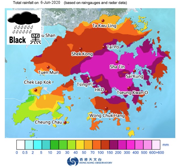
The western and southern parts of Lantau island received less than 40 mm of rainfall that day, whilst the area around Sha Tin received over 400 mm. The distance between the boundary of >400 mm and <40 mm is a few kilometres.
Cloudburst precipitation is incredibly spatially variable, so it is not the case that a failure to record heavy rainfall on a sparse rain gauge network means that such events did not occur. And, as I have shown on numerous occasions on this blog, intense rainfall most certainly can, and does, trigger catastrophic debris flows.
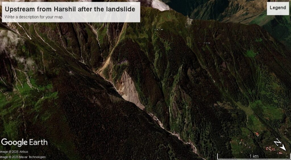
However, there was a stronger piece of evidence that suggests that this event was not a glacier burst or a GLOF. On 5 August 2025, the debris flows occurred in two separate, but adjacent catchments, one at Dharali but another at Harshil, about 500 m to the west. These two catchments are not connected, but they are separated by a ridge. This would suggest a common trigger – in the absence of an earthquake, a localised rainfall event is highly likely (especially in the peak of the monsoon).
Of course, to be sure we need either fieldwork or satellite imagery. In the rainy season, this is really hard to achieve but as the monsoon withdraws this becomes possible. And sure enough, on 11 September 2025, Planet captured a fabulous satellite image that starts to reveal the story.
So let’s start with Harshil – the picture here is straightforward. The slider below shows Harshil and the lower part of the catchment using Planet imagery draped onto the Google Earth DEM. Note that the change in the topography is not captured in the DEM.
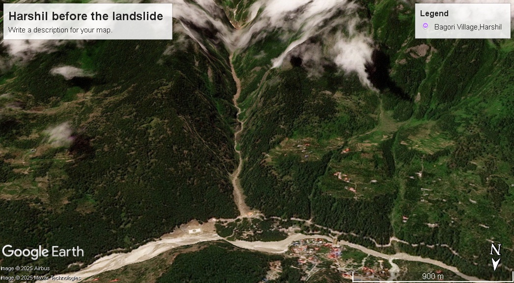
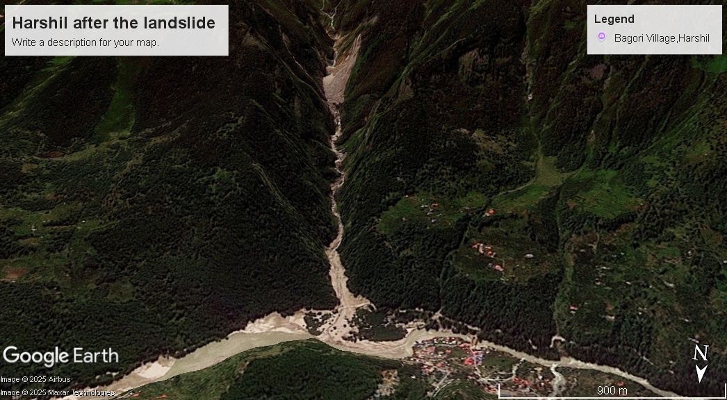
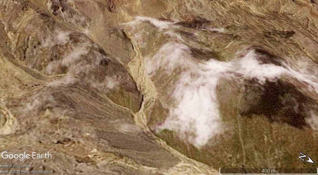
The path of the debris flow is clear, and upstream there is a very obvious large landslide. Thus, the most likely cause of the Harshil debris flow is that slope failure.
The image below shows the landslide itself, but again note that the topography in the DEM has not updated, so the morphology is distorted. But this is clearly a large rock slope failure.
I will caveat to say that at this stage we cannot definitively say that this landslide occurred on 5 August 2025, but Occam’s razor implies that this is the cause.
This slope failure has released a huge amount of sediment into the catchment. This will cause problems for Harshil in the future.
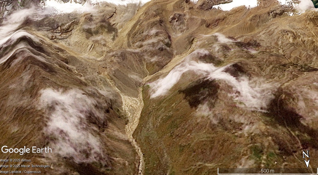
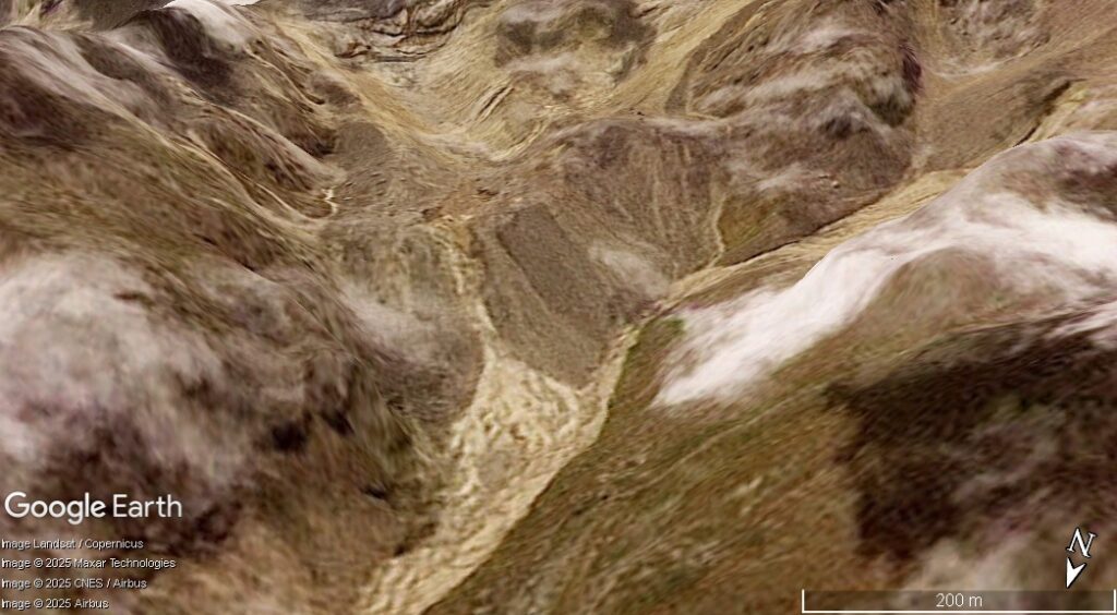
So now let’s turn to Dharali itself. This is more complex. We have to go high up into the catchment above the village to see what’s happened. The slider below shows before and after Planet images of the upper part of the catchment above Dharali:-


There has been substantial change on both sides of the catchment. Let’s start with the west (the right side of the image above as the image is from the south looking towards the north):-
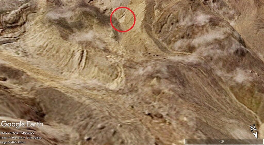
The juxtaposition of the sediments lower down the valley suggests to me that this was the cause of the first (most catastrophic) debris flow at Dharali. The image strongly indicates that this was a channelised debris flow initiated by a landslide in glacial sediments in the upper part of the catchment. There was a huge amount of entrainment of channel sediments downstream. Note that there is a pre-existing, smaller, landslide at this site.
Thus, the major debris flow at Dharali was probably initiated by a shallow landslide that transitioned into a channelised debris flow.
Events on the east side of the catchment are much less clear. I suspect that the processes here generated at least some of the smaller debris flows that struck Dharali after the first event. This is the Planet image for this side of the valley:-
The changes to the fan in the centre of the image are notable, but what caused this? I am not entirely sure. A closer comparison of the glacial sediment above this fan looks like this:-


In the foreground is a trough that has suffered extensive erosion. But there is also major change in the slopes above that trough. I have a suspicion that the feature that I have highlighted below might be quite significant:-
It appears to me that a landslide has occurred on this area of glacial sediment. Did this generate one or more channelised debris flows? There are other changes too – so maybe there were repeated shallow failures that generated the smaller debris flows observed at Dharali?
In conclusion, we can say:
- The Dharali disaster was caused by rainfall. There is no other credible trigger that explains simultaneous events in two separate, adjacent, catchments.
- Given the rain gauge record, this must have been a highly localised, cloudburst event.
- Harshil was destroyed by a debris flow that probably originated from a rock slope failure in the catchment above the village.
- The first Dharali debris flow was probably triggered by a rainfall triggered shallow landslide in glacial deposits in the upper part of the catchment, which transitioned into a channelised debris flow.
- The subsequent debris flows at Dharali were caused by other erosive events in these glacial tills. The origin is not entirely clear, but there is evidence of at least one further shallow landslide that may have been the origin for one or more events.
This is a very provisional analysis based on lower resolution (but still brilliant) imagery. These hypotheses need to be explored through fieldwork and/or high resolution imagery.
Finally, it is absolutely inevitable that the fans at Dharali and Harshil will suffer similar events in the future. Neither will be safe for habitation.
Reference and acknowledgement
Thanks to loyal reader Jack for really interesting and stimulating discussions about these events. And special thanks to Planet for the astonishing imagery.
Planet Team (2025). Planet Application Program Interface: In Space for Life on Earth. San Francisco, CA. https://www.planet.com/