Humans have developed many methods for determining true north, but each has its limitations. To navigate by stars, for example, the sky must be dark. Magnetic compasses are affected by interference from sources ranging from iron-bearing rocks to magnets in electronic devices. Satellite navigation systems such as GPS are vulnerable to phenomena such as space weather.
Some animals navigate using the sky itself. Skylight polarization, invisible to the human eye but perceived by animals such as desert ants, is due to Rayleigh scattering, which describes the phenomenon in which sunlight is scattered by small particles in Earth’s atmosphere.
Recently, researchers took a cue from nature and developed a method of orientation using skylight polarization. By looking at patterns of polarized sunlight, the scientists figured out how to calculate Earth’s true north pole and the latitude of an observer on the surface.
SkyPole
The polarization of skylight depends on the Sun’s position relative to the point of observation on Earth. In most parts of the world, polarization regularly changes throughout the day: When the Sun is close to its zenith, the sky will be polarized horizontally along the entire horizon. When the Sun is rising or setting, the sky will be maximally polarized vertically at the horizon.
At the celestial poles, however, the scattering angle is constant, explained Thomas Kronland-Martinet, lead author of the new study and a doctoral student in biorobotics at Aix-Marseille Université in France. Celestial poles are points in the sky that appear directly overhead to observers at Earth’s North Pole and South Pole, and polarization patterns rotate around them.
Kronland-Martinet and his colleagues studied the degree of linear polarization (DoLP), which is defined by the ratio between polarized light intensity and total light intensity. By measuring the DoLP between at least three time periods, Kronland-Martinet and his colleagues were able to determine true north with a mean error of 2.6°. (In comparison, he said that “state-of-the-art polarization-based geolocation errors are about 0.1° in latitude, longitude, and north bearing. However, those methods use other information than polarization [time, date, ephemeris, position estimation, inertial navigation systems] and good data processing.”) When the position of the north celestial pole (true north) is known, the observer can deduce their latitude.
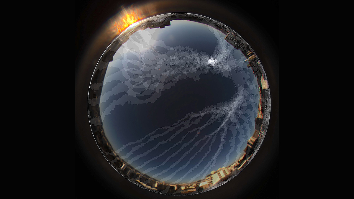
The researchers tested their method, called SkyPole, using a polarimetric camera fitted with a fish-eye lens, mounted to the roof of a building in Marseille, France. They reported their results in the Proceedings of the National Academy of Sciences of the United States of America.
Proof of Concept
“The study suggests a magnificent, but not entirely new, method.”
“The study suggests a magnificent, but not entirely new, method, as there have been previous, less successful attempts to use the polarization patterns of daylight” to determine true north, said Wisam Eldin Mahammed, a specialist in geographic information systems (GIS) at Imam Abdulrahman Bin Faisal University in Saudi Arabia, who was not involved in the research.
The suggested tool is not suitable for instantaneous global positioning, Mahammed explained. “So this method may not be practical in the presence of autopilots and drones that need real-time locations.”
Kronland-Martinet acknowledged that the SkyPole method is more a proof of concept than an immediately practical tool, but responded that with more development, the time needed to calculate position could be shortened to a few minutes or even seconds.
Dmitry Kishkinev, a lecturer in animal behavior and behavioral neuroscience at Keele University in the United Kingdom, said that “the findings seem to be correct and interesting as a proof of concept study.” Kishkinev, who was not involved in the new research, studies how animals navigate. He said he believes that the paper “does not add something very new into the field as new knowledge because this method was known, but it demonstrates a practical showcase of this method, validates it, and estimates an error.”
“It is interesting for me to see that with a simple camera and a fish-eye lens, one can estimate the latitude and the north,” Kishkinev said. “But it is no surprise that this has a relatively large error.”
Kronland-Martinet said that as SkyPole is further developed, it may be used to improve compass calibration or marine navigation by enabling the development of automatic polarimetric sextants.
—Mohammed El-Said (@MOHAMMED2SAID), Science Writer