
Source: Geochemistry, Geophysics, Geosystems
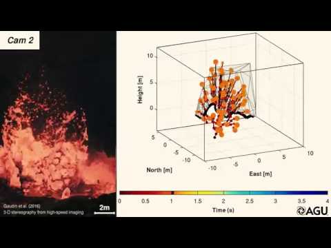
In explosive volcanic eruptions, bits of fragmented magma can be shot through the air by the release and expansion of pressurized gas. The trajectory map of these centimetric to decametric fragments, called “bombs,” is an important parameter in the study of explosive eruptions and the dangers that they present: Understanding how fast the debris is moving, how far it moves, and in which direction pieces travel could help scientists assess the hazards of volcanic eruptions or man-made explosions. In a new paper, Gaudin et al. present a method for studying the motion of volcanic bombs in three dimensions, allowing for more precise trajectory reconstructions.
There are several conditions that make observing active volcanic vents and bombs difficult, including the obvious difficulty of getting cameras close to the vents. The most significant of the problems is the large number of bombs from each explosive event that may change shape in flight and whose flight paths overlap with one another.

These limitations make any automatic tracking difficult or impossible, so the scientists simplified their procedure by relying on manual tracking of a few representative bombs rather than a computerized account of every single one. By placing two or more high-speed video cameras at well-documented positions around the volcanic vent, they were able to manually determine an object’s location in all of the images, computing the object’s position in three dimensions.
The human component of this manual process can be a major source of error since the person tracking the bombs makes a series of subjective choices, like deciding where exactly on the object to select as a representative point in each frame. If the cameras are tilted at all, that can also be a significant component of uncertainty in the measurements.
In the new study, the team was able to reduce uncertainty to 10° in angle and 20% in speed of the bombs. They used three events as examples: a bursting bubble at the Halema‘uma‘u lava lake in Hawaii, in-flight bomb collision, and an explosive ejection event at Stromboli volcano in Italy. A video showing the bursting bubble followed by the explosive ejection and their model in action is given below.
In Stromboli’s case, the reliability of the trajectory reconstruction was demonstrated by comparing the 3-D reconstruction with the low-speed, low-resolution cameras of the Stromboli permanent monitoring network. These case studies demonstrated just a few of the numerous contexts in which this 3-D tracking method could be useful, both within and beyond the study of volcanic vents and magma. (Geochemistry, Geophysics, Geosystems, https://doi.org/10.1002/2016GC006560, 2016)
—Leah Crane, Freelance Writer
Citation:
Crane, L. (2017), Tracking volcanic bombs in three dimensions, Eos, 98, https://doi.org/10.1029/2017EO068763. Published on 13 March 2017.
Text © 2017. The authors. CC BY-NC-ND 3.0
Except where otherwise noted, images are subject to copyright. Any reuse without express permission from the copyright owner is prohibited.