
A belt of persistent westerly winds circles the Southern Hemisphere midlatitudes. These winds influence Earth’s climate system on annual to millennial timescales.

Variations in the path and strength of these Southern Hemisphere Westerly Winds (SHWW) influence Southern Hemisphere rainfall and temperature patterns, Antarctic sea ice extent, and the ability of the ocean’s life-forms to produce nutrients. The SHWW’s interaction with the vast Southern Ocean (Figure 1) causes farther-reaching effects, where wind-driven upwelling helps regulate the exchange of carbon dioxide (CO2) between the deep-ocean carbon reservoir and the atmosphere.
The regional and global climatic significance of the SHWW demands a deeper understanding of the effects and history of their variability. But such an understanding is beyond the scope of the short period in which humans have had instruments to record scientific data.
Fortunately, nature has provided a much longer historical record in the form of sediment layers deposited sequentially, like pages in a book, on lake beds. Lake Ohau lies east of New Zealand’s Southern Alps in the northern margin of the SHWW belt, but enough rain spills over these mountains into the lake’s catchment to make the resulting river inflow sensitive to variations in westerly wind flow. This relationship provides a connection between the SHWW, rainfall, flood frequency, and sediment accumulation in Lake Ohau.
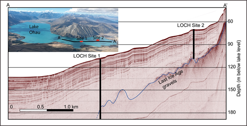
Sediments deposited in the lake bed are known to vary from year to year in response to regional climate changes [Roop et al., 2016]. Seismic profiles confirm that layered sediments have been accumulating on the lake bed (Figure 2) since the lake’s formation at the end of the last ice age, around 17,000 years ago [Putnam et al., 2013].
To learn more about the history of the SHWWs, we conducted a drilling program in February–March 2016 to recover a complete sediment record spanning the late glacial period until recent times. We dubbed this effort the Lake Ohau Climate History (LOCH) project.
A Shift in the Winds
The Southern Hemisphere Westerly Winds are currently moving south in response to a changing atmospheric temperature profile caused by anthropogenic ozone.
The SHWW are currently moving south in response to a changing atmospheric temperature profile caused by anthropogenic ozone. This effect is expected to diminish as the southern “ozone hole” becomes smaller. The consequences of this shift are evident in both southern New Zealand, where summer rainfall has decreased by as much as 40% in the past 3 decades, and the Southern Ocean, where the strength of winds is a contributing factor in the Southern Ocean’s ability to absorb atmospheric CO2.
Instrumental records of the SHWW span only a few decades. So we do not have a long-term perspective in which to place current changes.
For example, what is the natural magnitude of year-to-year variability during periods warmer than today? How did the SHWW respond to past periods of enhanced warming and cooling in the Northern Hemisphere’s paleoclimate records? Climate models suggest that the SHWW belt responds to a number of forcing factors that vary on millennial to human timescales, but how well do they “hindcast” past SHWW movements?
The LOCH project aims to answer these questions.
Establishing a Record of Southern Hemisphere Westerly Winds at Lake Ohau
The SHWW flow over substantial topography in only two regions: southern South America and southern New Zealand. As moisture-laden westerly flowing air is forced over these north–south-oriented mountain ranges, the air cools, and the moisture within it condenses into substantial amounts of precipitation [e.g., Garreaud, 2007]. The Ohau catchment receives enough rainfall spilling over the Southern Alps to provide a link between wind strength and precipitation.
Before we took a deep dive into a long sediment core to explore past precipitation patterns, we needed to understand what processes currently form sediment layers. Our monitoring program in Lake Ohau, which started 7 years ago, collects detailed instrumental data so we can observe how changes in rainfall patterns and river inflow are represented in the stratigraphy preserved on the lake floor.
We hope to extrapolate what we know has happened to what may have happened in past centuries and millennia.
Throughout the monitoring period, we observed two floods of a magnitude that has occurred only once every decade or so over the past 90 years. These floods deposited centimeter-thick, fine silt layers, in contrast to the millimeter-scale laminations that we typically see in sediment cores. These layers provide the basis for identifying past flood events.
Changes in the character of the millimeter-scale laminations over time are more complex. In addition to flood layers, we saw in existing short cores two other types of coarse- and fine-sediment pairings in the past century. Thinner than average couplets of fine and very fine silt correspond to drier summers, and thicker couplets or stacks of couplets deposited within a year represent wetter summers.
With this information, we hope to extrapolate what we know has happened to what may have happened in past centuries and millennia.
Collecting the Cores
We chose two drill sites (LOCH 1A/B, 105-meter water depth, and LOCH 2A/B, 68-meter water depth) in the sheltered southeastern arm of the lake (Figure 2, inset). Detailed bathymetric surveys performed by autonomous underwater vehicles, seismic profiling of the lake bed, and previously recovered short cores showed that these distal locations were free of prominent slumps and the centimeter- to decimeter-thick graded sand deposits that characterize the delta, margins, and central basin of the lake. Thus, these locations were ideal for observing sediment layers that have been relatively undisturbed since they were deposited.
The development of a new platform-corer combination was a critical part of the drilling initiative. This system had to be small enough to be transportable on a standard 40-foot (12.2-meter) container/flatbed truck but still able to recover high-quality cores in unconsolidated sediments at depths to 150 meters. The result was a system that combined technology based on Ocean Drilling Program hydraulic piston corer (HPC) principles and a custom-designed barge, developed and operated by Webster Drilling and Exploration. Anchor lines hold the barge securely in position while it is drilling, as seen in the video below.
At both sites we aimed to double core or offset core the entire sediment sequence to provide overlap for the gaps of about 10 centimeters that occur between each 3-meter run of the HPC. At site 2 we were able to offset core the complete 42-meter-thick layered (laminated) sedimentary sequence. At the more exposed and deeper site 1, we offset cored the upper 60 meters, but only drill hole 1B extended down to the ice age gravels 80 meters below the lake floor.
Analyzing the Core Samples
To characterize the sediment layers as thoroughly as possible, we obtained X-ray images of cores on site and subsequently scanned them using X-ray computed tomography (CT scan), which generates density data at about 600-micrometer resolution for the whole volume of the core. We’re also in the midst of performing additional high-resolution layer measurements using X-ray fluorescence and nonvisible light reflectance, and we are analyzing paleomagnetic properties. These data will provide the layer-by-layer detail we need to unravel climatic changes preserved in the core stratigraphy at an annual scale.
We’ve also examined the core for palynomorphs (fossil pollen, spores, and charcoal) and diatoms. These examinations have been done initially at millennial resolution from core catcher samples, but planned improvements in this resolution will enable us to reconstruct detailed changes in temperature, rainfall, and lake hydrology over time.
We also plan to use a relatively new organic biomarker geochemical approach, namely, changes in the composition of a class of sugar alcohols called branched isoalkyl glycerol dialkyl glycerol tetraethers (brGDGTs) to quantify climatic changes. These compounds are produced by bacteria, and they show predictable variation with temperature [e.g., Zink et al., 2016].
This combination of paleoclimate proxies is designed to yield the most quantitative reconstructions of temperature and rainfall and the nature of the surrounding environment at the highest possible resolution.
Preliminary Results
Radiocarbon dating of leaves and twigs embedded in the cores suggest that sedimentation rates at site 1 (Figure 2) have been uniform, although rates from the first 11,000 years appear to be slightly slower than those from the latter part of the core. This chronology will be further improved by additional radiocarbon ages and layer counting.

Our palynomorph data show vegetation progressions that seem to be in line with climate warming and cooling trends shown in other records of the region. The core stratigraphy—the sequence of glacial deposits, ice rafted debris, and lake sediments—revealed in the CT images seems to reflect these changes too (Figure 3).
Close examination of the CT scanner data shows marked changes in the character of the fine layers down core, which suggests decadal to centennial changes in rainfall patterns. Interpreting the details of these changes will take time, but variations in the frequency of large flood events over the past 2000 years stand out clearly.
Moving Ahead
We plan to integrate paleoenvironmental reconstructions based on LOCH drill cores with similar records from Antarctic ice cores and sediment cores from sub-Antarctic islands and Patagonia. Through these reconstructions, we will form a transect across the SHWW belt to investigate past variation in this wind system.
With a firm knowledge of the past, we can better anticipate potential future behavior.
A high-resolution sediment record was recently recovered from an Auckland maar crater to the north of this wind belt [Augustinus, 2016]. Comparisons with the paleoclimate record from this site (and other lower-latitude sites in South America) will also allow us to investigate in detail the interaction between subtropical and midlatitude climate systems over the Holocene.
We hope to combine observations with global and regional climate model simulations to build a greatly improved understanding of the past causes, timing, and magnitudes of high-frequency climate variability in the Southern Hemisphere midlatitudes. With a firm knowledge of the past, we can better anticipate potential future behavior.
Acknowledgments
The LOCH project is a collaboration between GNS Science, Victoria University of Wellington, University of Otago, Northern Arizona University, Istituto Nazionale di Geofisica e Vulcanologia, University of New South Wales, Indiana State University, and New Zealand’s National Institute of Water and Atmospheric Research. Financial support for this project was provided through the GNS Science Global Change through Time program and the Royal Society of New Zealand Marsden Fund (GNS1302). The project has greatly benefited from the input of many people and organizations over the past 6 years. In particular, the authors thank Meridian Energy and the University of Otago Marine Sciences Department (Dunedin, New Zealand) for logistical support during drilling.
References
Augustinus, P. C. (2016), Probing the history of New Zealand’s Orakei maar, Eos, 97, https://doi.org/10.1029/2016EO059227.
Garreaud, R. (2007), Precipitation and circulation covariability in the extratropics, J. Clim., 20(18), 4789–4797, https://doi.org/10.1175/JCLI4257.1.
Mayr, C., et al. (2013), Intensified Southern Hemisphere westerlies regulated atmospheric CO2 during the last deglaciation, Geology, 41(8), 831–834, https://doi.org/10.1130/G34335.1.
Putnam, A. E., et al. (2013), The Last Glacial Maximum at 44°S documented by a 10Be moraine chronology at Lake Ohau, Southern Alps of New Zealand, Quat. Sci. Rev., 62, 114–141, https://doi.org/10.1016/j.quascirev.2012.10.034.
Roop, H. A., et al. (2016), A hydroclimate-proxy model based on sedimentary facies in an annually laminated sequence from Lake Ohau, South Island, New Zealand, J. Paleolimnol., 55(1), 1–16, https://doi.org/10.1007/s10933-015-9853-3.
Zink, K.-G., et al. (2016), A refined paleotemperature calibration for New Zealand limnic environments using differentiation of branched glycerol dialkyl glycerol tetraether (brGDGT) sources, J. Quat. Sci., 31(7), 823–835, https://doi.org/10.1002/jqs.2908.
Author Information
Gavin B. Dunbar (email: [email protected]), Antarctic Research Centre, Victoria University of Wellington, New Zealand; and Marcus J. Vandergoes and Richard H. Levy, GNS Science, Lower Hutt, New Zealand
Citation:
Dunbar, G. B., M. J. Vandergoes, and R. H. Levy (2017), Shifting winds write their history on a New Zealand lake bed, Eos, 98, https://doi.org/10.1029/2017EO073279. Published on 16 May 2017.
Text © 2017. The authors. CC BY-NC-ND 3.0
Except where otherwise noted, images are subject to copyright. Any reuse without express permission from the copyright owner is prohibited.