Just as chemists have their periodic table, Earth scientists can lay claim to their own brightly colored reference diagram: the International Chronostratigraphic Chart, which divides our planet’s 4.5-billion-year history into meaningful chunks of time.
Last month, researchers laid the groundwork for defining the current epoch of geologic time—a new line on that chart—that would cap the Holocene. They voted that Crawford Lake, a small body of water in southern Canada, serve as the reference site of the new proposed geologic epoch: the Anthropocene.
A Legendary Interruption
In early 2000, Paul Crutzen, an atmospheric chemist and meteorologist, famously interrupted a speaker at a scientific meeting in Cuernavaca, Mexico. The current time period shouldn’t be thought of as part of the Holocene, a geological epoch that began 11,700 years ago, Crutzen argued, but rather an entirely distinct period. The name he suggested for the new epoch, the Anthropocene, was a nod to humanity’s increasingly pronounced influence on the planet’s land, sea, and air. Other researchers had previously proposed a similar concept, with even the same name, but Crutzen, thanks to his many scientific accomplishments (including a Nobel Prize in 1995), was instrumental in popularizing the idea of the Anthropocene.
The public has come to embrace the term: It’s been used in music, literature, and multimedia. Scientists have adopted the word as well—several research journals include “Anthropocene” in their title, and a handful of institutes also reference the term in their name.
“It ramped up very quickly,” said Francine McCarthy, a micropaleontologist at Brock University in St. Catharines, Ont., in Canada. “It caught on like wildfire.”
Flying Rogue
“People can go to it and put a finger on it and say ‘We can see that’s the boundary of this unit.’”
But not everyone was happy. Stratigraphers in particular were galled by the widespread use of the new term, McCarthy said. That’s because the word was, in essence, flying rogue—the International Union of Geological Sciences, the governing body responsible for the International Chronostratigraphic Chart, still hasn’t formally approved the geologic unit of time. “Stratigraphers are very rule-bound people,” McCarthy said. But it was too late to take back the term, she said. “The genie was out of the bottle.”
In 2009, the International Union of Geological Sciences tasked one of its scientific offshoots, the International Commission on Stratigraphy, to create a committee to investigate the merit of formally defining the Anthropocene. That committee, known as the Anthropocene Working Group, consisted of roughly 40 members, including scientists, historians, archaeologists, and other scholars. By 2016, the group had been given the official go-ahead to begin the task of selecting the site of the proposed epoch’s so-called “golden spike.”

Of the more than 115 intervals of geologic time indicated on the International Chronostratigraphic Chart, 80 are associated with a specific physical site. Such locales—termed Global Boundary Stratotype Section and Points—hold clear-cut evidence of that unit of time in the geologic record, said Colin Waters, a geologist at the University of Leicester in the United Kingdom and the current chair of the Anthropocene Working Group. “People can go to it and put a finger on it and say ‘We can see that’s the boundary of this unit.’” (Some Global Boundary Stratotype Section and Points are marked with brass plaques, hence the reference to a golden spike.)
But deciding on one location that typifies humans’ influence on the planet was no small feat, said Waters. The proverbial fingerprints of our species—fallout from nuclear weapons testing, particulate matter from combustion, and nitrogen from fertilizer runoff, to name a few—are littered across the recent geologic record. “We had the whole world to choose from,” Waters said.
A Mid-20th-Century Signature
The Anthropocene Working Group stipulated, however, that a site had to demonstrate a clear signature of anthropogenic influence around the 1950s. Crutzen, when he originally suggested the concept of the Anthropocene, suggested that it ought to begin around the time of the Industrial Revolution, in the 18th and 19th centuries. But the Anthropocene Working Group proposed a mid-20th-century start of the Anthropocene to coincide with the globally synchronous signature of radionuclides such as plutonium and carbon from nuclear weapons testing around that time. (That decision has been contentious, however, and members of the Anthropocene Working Group have resigned over the matter.)
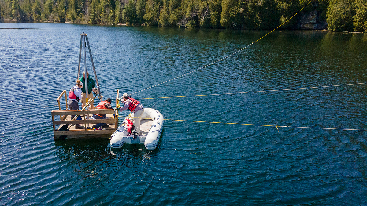
The Anthropocene Working Group challenged teams of researchers to submit papers presenting their proposed sites to a journal aptly named The Anthropocene Review. Twelve teams met the 1 July 2022 deadline, and nine of the proposed sites passed the peer-review process. It took three rounds of voting among Anthropocene Working Group members to obtain the 60% majority vote necessary to declare a winning site: Crawford Lake in Ontario, Canada. The bottom of the 24-meter-deep lake is blanketed in striated layers of calcite and sediments that exhibit striking upticks not only in radionuclides associated with nuclear weapons testing but also carbon-rich particles a few micrometers in diameter—so-called fly ash produced by the burning of coal—that can be precisely dated to the 1950s. Researchers study those layers by plunging a freezing cold metal tube into the bottom of the lake, leaving it there for anywhere from 20 to 40 minutes, and then hauling it back to the surface; the material that is frozen on the tube preserves the intricate, millimeter-scale layering of the lake bottom.
McCarthy led the team that put forth the proposal for Crawford Lake. She has a long history with Crawford Lake—she first visited the site as a graduate student at the University of Toronto in the 1980s. It’s exciting to think that a little slice of nature just 90 minutes from Toronto might serve as a reference for a new geologic epoch, McCarthy said. “What were the odds it would end up being this tiny lake in Canada?”
The next step to formally defining the Anthropocene requires votes from the International Commission on Stratigraphy and the International Union of Geological Sciences. The final vote will likely take place next August at the 37th International Geological Congress in Busan, South Korea.
—Katherine Kornei (@KatherineKornei), Contributing Writer