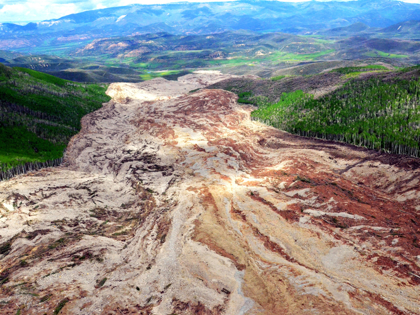
Early in the morning on 25 May 2014, Melvin “Slug” Hawkins heard a strange hissing noise coming from outside his home in Grand Mesa, western Colorado. Later that day, his son and two other men set out to figure out why water had stopped flowing into an irrigation ditch. By that evening, Hawkins’s son and his two companions were dead—victims of a massive rockslide that careened without warning down the nearby West Salt Creek valley.
The West Salt Creek rock avalanche moved 54 million cubic meters of rock over a distance of 4 kilometers in less than 4 minutes. Its size and speed, as well as its tragic aftermath and remaining hazard, piqued the interest of scientists at the U.S. Geological Survey (USGS), who published a paper this week in Geosphere detailing their forensic analysis of the deadly flow.
“There’s this ongoing hazard that makes it important to understand what happened in the first event,” said Jeffrey Coe, a research geologist at USGS in Denver, Colo., and lead author on the paper.
Cascade of Events
If you had been standing in the creek, Coe said, you would have seen a 40-meter-high wall of rock rushing at you from above.
Many people might imagine a rockslide as a single massive flow of rock and debris, but Coe and his team found that the West Salt Creek rock avalanche collapsed in a series of distinct events. The hissing noise that Slug Hawkins heard came from a smaller precursor debris flow that occurred several hours before the side of the valley came crashing down.
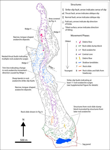
Using drones to build a detailed map of the aftermath, seismic data to study its movement, and eyewitness accounts to corroborate the events, the researchers cobbled together a picture of the 3.5-minute rockslide.
Rain falling on snow was the definite trigger, Coe said. This kind of rock avalanche can be triggered by snowmelt alone, but when it rained, the snow melted faster. Water then mixed with more friable bits of rock and debris, which cascaded down the slope. Seismometers more than 100 kilometers away picked up the early morning debris flow, which the researchers call phase 1. Phase 2 occurred hours later, when a solid mass of rock slid suddenly, activating phase 3, the huge avalanche composed of loose pieces of rock and other debris that cascaded down 600 meters over a distance of about 4 kilometers into the valley below—stopping short of ranches and gas wells.
After this mass settled, eyewitnesses searching for the missing men say that its core along the valley bottom continued to flow. Sure enough, the researchers found mini strike-slip faults within the flow, confirming that its middle kept moving even though edges stayed stationary. Another debris flow topped off the tumultuous events.
Seismic Analysis
Armed with seismic data from the event, the researchers then determined how fast the rockslide moved—between 15 and 36 meters per second (equivalent to 35–80 miles per hour). To calculate this, they worked backward from seismic data to determine the changes in magnitude and direction of the avalanche’s force as it pinballed around kinks and curves in the valley.
The seismic waves tell us “what the landslide was doing, on average, at each moment in time,” said Kate Allstadt, a research geophysicist at USGS in Golden, Colo., and a coauthor on the paper.
Coe and his colleagues suspect that the mass moved so fast because the underlying moist ground had liquefied, splitting the avalanche into two distinct layers.
Future of Landslides
The researchers hope that by studying this particular rock avalanche in detail, they can provide useful insights into landslides, which kill between 25 and 50 people each year in the United States. For instance, the precursor flow that occurred early in the morning was picked up by seismometers over 100 kilometers away—Coe wonders if more seismometers and more sensitive seismometers could help scientists tease apart how and if smaller landslides precede larger ones.
Although scientists can characterize landslides using seismic data, “we would not know for sure if a small landslide event was the main event or a precursor to a larger event until the larger event occurred—or didn’t occur,” Allstadt said.
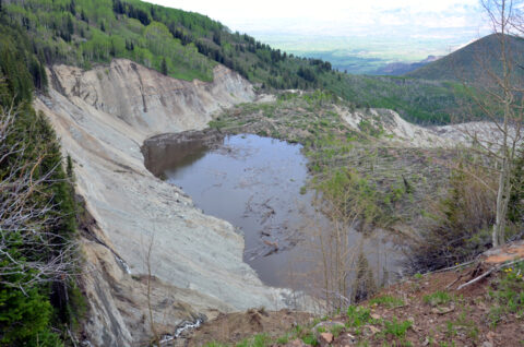
The hazard at this particular slope isn’t over yet—at the top of the creek, a depression formed following the avalanche that at its fullest holds 500,000 cubic meters of water. This “sag pond” could weaken the slope and cause another rock avalanche, or rock from the steep slope above it could fall, generating a small-scale tsunami that pushes water onto the unstable slope below, Coe said.
Even though a natural drainage pipe now helps to drain the pond, “there’s this concern about what will happen during the spring snowmelt season,” Coe said, so they’re keeping an eye on the area for now.
—JoAnna Wendel, Staff Writer
Citation: Wendel, J. (2016), Forensic analysis of landslide reveals rocky secrets, Eos, 97, doi:10.1029/2016EO047449. Published on 4 March 2016.
Text © 2016. The authors. CC BY-NC 3.0
Except where otherwise noted, images are subject to copyright. Any reuse without express permission from the copyright owner is prohibited.