An unexpected burst of rainfall has mostly extinguished the massive wildfires that have been ravaging the area near Sisimiut in southwestern Greenland for the past 3 weeks, according to a report by the Greenland Police on 21 August (via Google Translate). Local emergency response warned that there was still a small risk that the fire may reignite from small patches that are still smoldering.
“We were all hoping for rain.…The potential for fighting the fire was quite low.”
“We were all hoping for rain,” said Jessica McCarty, wildfire geographer at Miami University in Oxford, Ohio. “Most of the wildfires, including the largest, were remote enough that the potential for fighting the fire was quite low.”
The situation is much improved from 17 August, when imagery from the European Space Agency (ESA) satellite Sentinel-1 compiled by Dominique Derauw of Université de Liège in Belgium showed that the wildfire had split into three distinct hot spots and was still growing from where it started on 29 July in a region about 150 kilometers (90 miles) northeast of Sisimiut:
#Greenland #wildfire slowing down but still growing. Animation updated with #InSAR coherence of #Sentinel1 pair of 20170817-20170811. pic.twitter.com/8ey5weEWNN
— Dominique Derauw (@DDerauw) 18 August 2017
Derauw estimated that by 17 August the fire had spread to an area of about 22 square kilometers (5,400 acres). June and July before the fire were exceptionally dry months for the region, and little rain was expected in the days following the outbreak. But in a stroke of luck, the parched land near Sisimiut received about 130 millimeters (5.1 inches) of rain between 17 and 21 August, which helped to douse the wildfire.
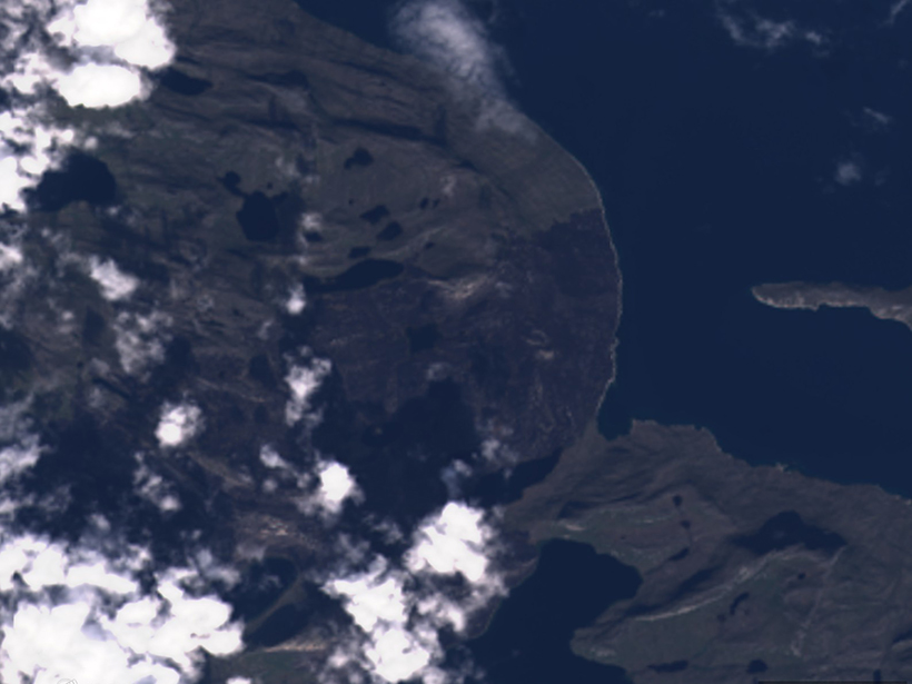
A sequence of satellite imagery from ESA’s Sentinel-2 and NASA’s Landsat 8 from 31 July to 21 August, compiled by Stef Lhermitte of Delft University of Technology in the Netherlands, captures the fire’s fast growth and rapid death:
Now the Greenland wildfire is extinguished due to rain, here is a wrap-up of how it evolved in 3 weeks based on #sentinel2 and #landsat pic.twitter.com/iNGaHoTGwX
— Stef Lhermitte (@StefLhermitte) 22 August 2017
Just after the fire broke out, McCarty suspected that peat from newly thawed permafrost might be fueling the fire. Now that the fire is out, she told Eos that scientists are still “pretty sure that it is peat” but that an international team is “trying to create a field campaign to gather soils and permafrost data from these wildfire locations.”
Researchers have not yet assessed the level of black carbon that the wildfire may have deposited on the ice sheet.
McCarty also added that researchers have not yet assessed the level of black carbon that the wildfire may have deposited on the ice sheet but that there must have been at least some localized deposits. Because Greenland’s winter starts in late September, she indicated that field campaigns will likely need to wait until warmer months to begin.
“The investigation is ongoing,” McCarty said. “Look for more data and analysis next summer.”
—Kimberly M. S. Cartier (@AstroKimCartier), News Writing and Production Intern
Citation:
Cartier, K. M. S. (2017), Southern Greenland wildfire extinguished, Eos, 98, https://doi.org/10.1029/2017EO080905. Published on 29 August 2017.
Text © 2017. The authors. CC BY-NC-ND 3.0
Except where otherwise noted, images are subject to copyright. Any reuse without express permission from the copyright owner is prohibited.