
Ireland and Britain should be, seismologically speaking, equally boring. The two islands lie thousands of kilometers from the nearest plate boundary and are not volcanic hot spots. But though the ground rarely rumbles in Ireland, neighboring Britain experiences plenty of weak and moderate earthquakes.
The lithosphere—Earth’s outermost rocky veneer, which includes the crust and the solid upper mantle—is thicker and cooler beneath Ireland than it is beneath Britain, new research has suggested. Cool, thick lithosphere is mechanically stronger than warm, thin lithosphere, which could explain the Emerald Isle’s puzzling paucity of earthquakes. The new results, published in Geophysical Journal International, hinted that lithosphere thickness could underpin patterns in seismic activity in other places far from plate boundaries.
Ireland’s Missing Earthquakes
Around 90% of all earthquakes—including nearly all the most destructive ones—start at the boundaries between tectonic plates. Plate or continental interiors tend to be seismically quiet, though they’re not dead. The New Madrid Seismic Zone in the Mississippi River Valley, for instance, released a series of magnitude 7.3–7.5 earthquakes in late 1811 and early 1812, despite sitting in the middle of the North American plate.
“We have a very good frame of understanding seismicity at plate margins,” said geologist Mike Sandiford of the University of Melbourne, who wasn’t involved in the new study. “The question is, What’s controlling seismicity in continental interiors away from plate margins?”
The rarity of intraplate earthquakes has made it harder for scientists to understand them. And it’s often unclear why some places deep within continents have more earthquakes than others.
That’s the case in the British Isles, where the dramatic seismic contrast between Britain and Ireland is a centuries-old mystery.
Sergei Lebedev, a seismologist at the University of Cambridge and lead author of the new study, described the situation by quoting British Geological Survey seismologist Roger M. W. Musson: “The quest for understanding how the distribution of seismicity [in Britain and Ireland] relates to geological structure has been a long and unfruitful one.” The key question, Lebedev added, is why Ireland has so few earthquakes.
Faults aren’t the answer, Lebedev said, because many of Britain’s major faults cut through Ireland, too. Neither is the type of crust present on the two islands. Britain and Ireland share a geological history, both having been assembled from bits of an ancient continent called Laurentia and a scrap of crust called Avalonia during the Caledonian Orogeny—one of the mountain-building events that stitched together the supercontinent Pangaea.
“The crustal blocks that make [up the islands] go from Britain to Ireland,” Lebedev said, “and they have nothing to do with the distribution of seismicity.”
Seismic Scan
Until recently, Ireland’s missing earthquakes were a mystery without clues.
Until recently, Ireland’s missing earthquakes were a mystery without clues. In 2008, Lebedev said, there was just one broadband station monitoring Ireland’s apparently uninteresting seismology. But that’s since changed dramatically.
The Irish National Seismic Network now runs six permanent broadband seismometers and is expanding its network. Between 2010 and 2012, Lebedev and his colleagues deployed an additional 20 temporary seismometers that operated continuously until 2021.
With this beefed-up Irish seismic network and data from seismometers in Britain, Lebedev and his colleagues previously used surface wave tomography to map the thickness of the lithosphere in Britain and Ireland. The technique takes advantage of the fact that some seismic waves travel quicker through colder lithosphere, which also tends to be thicker. With it, scientists can map subsurface structures in 3D. “It’s akin to medical tomography where doctors shoot different kinds of rays through patients and find out what’s inside them,” Lebedev said.
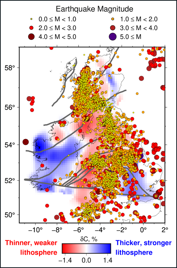
Then, in the new study, the research team made a detailed map of seismic activity and compared it to their map of lithosphere thickness in Britain and Ireland. This comparison revealed a striking correlation: Earthquakes were scarce wherever the lithosphere was cold and therefore likely thick and strong.
“Ireland has low seismicity, and we see that it has thick, cold lithosphere,” whereas Britain’s lithosphere is warmer and thinner, Lebedev said. “Most Irish earthquakes are in the north of the island in County Donegal—more than 90% of them,” he added, “and they happen to be where the lithosphere is thin.”
Deep Structure
This isn’t the first time scientists have linked lithosphere thickness to intraplate seismicity in general. For instance, geophysicist Walter Mooney of the U.S. Geological Survey showed in 2012 that large intraplate earthquakes are vanishingly rare in places where surface waves travel quickly at 175 kilometers deep—an indication of a thick “lithospheric root,” he said.
However, it was long assumed that the lithosphere beneath Ireland and Britain was equally thick—there wasn’t any evidence to the contrary, Lebedev said. “So we have a 150-year-old puzzle that has been unsolved until now.”
There are still more puzzles—such as why Ireland’s lithosphere is thicker than Britain’s. Lebedev said his team hoped to answer that one soon. Lebedev also said he’d like to see whether surface wave tomography can uncover similar correlations between lithosphere thickness and seismicity elsewhere, beyond Britain.
“While lithosphere thickness tends to correlate with cooler temperatures, it doesn’t necessarily have to.”
However, “while lithosphere thickness tends to correlate with cooler temperatures, it doesn’t necessarily have to,” said Sandiford. This uncertainty can complicate simple generalizations associating lithosphere thickness with seismicity like those suggested in the new study, Sandiford said.
There are even places, such as western Australia, that are seismically active but have thick lithosphere. So, Sandiford added, “other factors are playing in. But it seems, as a first case, they make a reasonable assessment for Ireland and the British Isles.”
Many questions still surround seismicity within continents, and the new result is a good reminder that the answers can be buried deeper than scientists would expect, Mooney said. Traditionally, he said, seismologists focused on the top 15 or so kilometers of Earth’s crust because most earthquakes at plate boundaries are shallow.
Scientists assume “they don’t need to think about the lithosphere because it’s below their area of interest. That’s not true,” Mooney said. “Deeper structure has a big influence on shallow activity.”
—Elise Cutts (@elisecutts), Science Writer