Source: AGU Advances
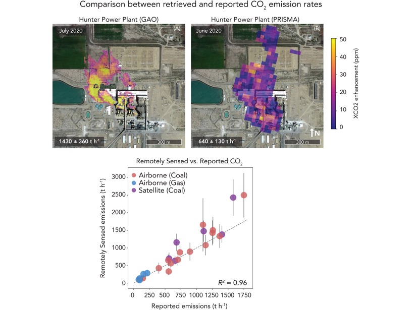
Carbon dioxide (CO2) emissions from power plants represents one of the largest sources of greenhouse gases from humans. Keeping track of CO2 emissions from all global power plants is difficult, as good emission data can depend on a country’s emission reporting protocols. However, remote sensing with imaging spectrometer instruments offers a new capability to do top-down monitoring. These instruments provide high spatial resolution CO2 plume maps which can be used to quantify emissions. Cusworth et al. [2021] show examples where CO2 emissions are quantified and validated at 21 global gas and coal fired power plants using airborne and satellite imaging spectrometers. With repeated targeting by satellites, it is estimated that 6 percent of all global power plant emissions could be constrained. This capability is key to reducing uncertainties in global anthropogenic CO2 emission budgets and supporting emissions mitigation strategies.
Citation: Cusworth, D. H., Duren, R. M., Thorpe, A. K., Eastwood, M. L., Green, R. O., Dennison, P. E., et al. [2021]. Quantifying global power plant carbon dioxide emissions with imaging spectroscopy. AGU Advances, 2, e2020AV000350. https://doi.org/10.1029/2020AV000350
—Donald Wuebbles, Editor, AGU Advances
Text © 2021. The authors. CC BY-NC-ND 3.0
Except where otherwise noted, images are subject to copyright. Any reuse without express permission from the copyright owner is prohibited.