Source: Geophysical Research Letters
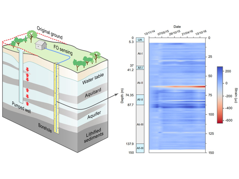
Land subsidence is a major problem in many areas. It usually occurs in deltaic regions, many of which are home to large human populations. Subsidence is typically due to compaction of specific fine-grained layers of geologic formations that are more elastic. However, pinpointing where underground compaction occurs is very challenging. Zhang et al. [2018] demonstrate that detailed vertical profiles of deformation can now be mapped using novel applications of fiber-optic sensing. They buried and installed a fiber-optic cable into boreholes and mapped the strain experienced by the cable. This allowed meter-scale mapping of where the hotspots for deformation are located. This opens many opportunities for applications in geomechanics and hydrology.
Citation: Zhang, C.‐C., Shi, B., Gu, K., Liu, S.‐P., Wu, J.‐H., Zhang, S., et al. [2018]. Vertically distributed sensing of deformation using fiber optic sensing. Geophysical Research Letters, 45. https://doi.org/10.1029/2018GL080428
—M. Bayani Cardenas, Editor, Geophysical Research Letters
Text © 2018. The authors. CC BY-NC-ND 3.0
Except where otherwise noted, images are subject to copyright. Any reuse without express permission from the copyright owner is prohibited.