Source: Water Resources Research
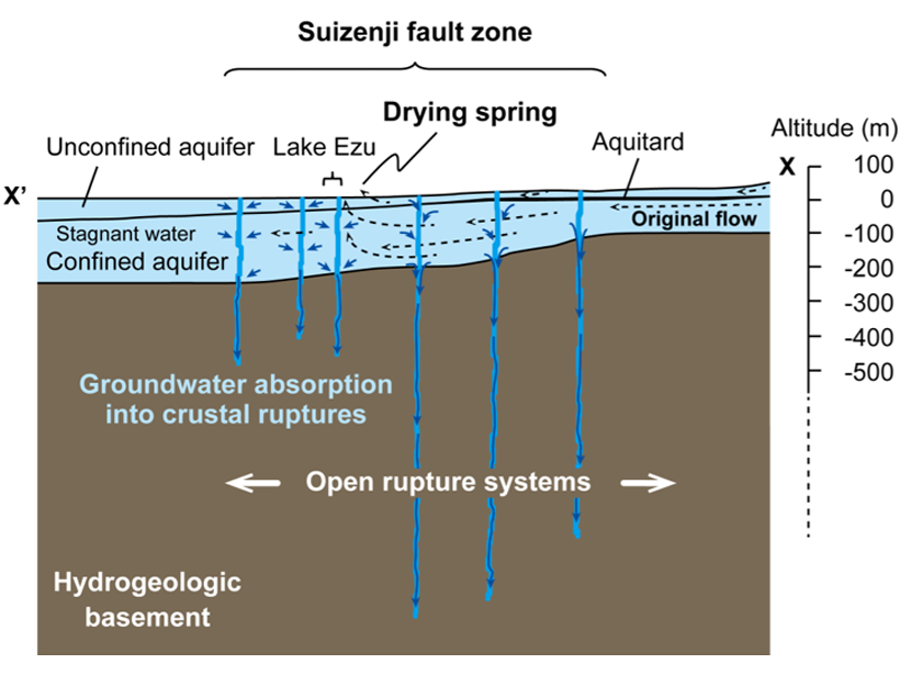
Major earthquakes are known to affect surface water and groundwater systems; for instance, by altering spring locations, making streams disappear, or causing groundwater levels to drop temporarily or permanently. The study by Hosono et al. [2019] is unique because it provides a rare set of high frequency observations of groundwater and surface water levels before, during, and after a large earthquake.
These data reveal that a large volume of water has disappeared through crustal ruptures formed during the quake, as shown in the diagram above. Not only does this reduce water availability in the region for a whole year but it also causes surface water and shallow groundwater to mix with deeper groundwater with possible long-term negative consequences for groundwater quality.
Citation: Hosono, T., Yamada, C., Shibata, T., Tawara, Y., Wang, C.‐Y., Manga, M., et al. [2019]. Coseismic groundwater drawdown along crustal ruptures during the 2016 Mw 7.0 Kumamoto earthquake. Water Resources Research, 55. https://doi.org/10.1029/2019WR024871
—Marc F. P. Bierkens, Editor, Water Resources Research
Text © 2019. The authors. CC BY-NC-ND 3.0
Except where otherwise noted, images are subject to copyright. Any reuse without express permission from the copyright owner is prohibited.