Source: Journal of Geophysical Research: Atmospheres
Mesoscale convective systems (MCSs) are a key component in the Earth’s energy and hydrological cycles. They can grow to hundreds of kilometers in size, last for more than a day, and produce a majority of the annual rainfall in many regions of the world.
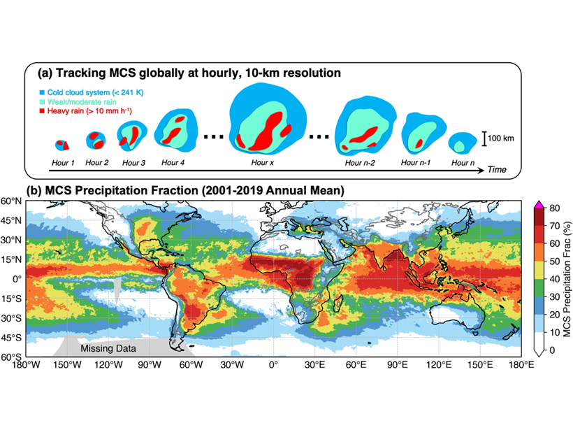
Past efforts to develop MCS databases have been limited to the tropics and used methodologies not well tested in the midlatitudes. Feng et al. [2021] developed a new methodology to track MCSs globally using high-resolution satellite observations of both cloud and precipitation. The new method significantly improves the detection of MCSs in the midlatitudes. This new storm tracking database is the first to cover both the tropics and midlatitudes for all seasons.
The study shows that MCSs account for over 50 per cent of the annual rainfall across the tropics and many regions of the subtropics and midlatitudes. Storms over land have more intense convection, while those over oceans produce heavier rainfall and last longer.
This global MCS database supports a broad range of research such as understanding the role of MCSs in global extreme rainfall and circulation, and evaluation of global weather and climate model simulations.
Citation: Feng, Z., Leung, L. R., Liu, N., Wang, J., Houze, R. A., Li, J., et al. [2021]. A global high‐resolution mesoscale convective system database using satellite‐derived cloud tops, surface precipitation, and tracking. Journal of Geophysical Research: Atmospheres, 126, e2020JD034202. https://doi.org/10.1029/2020JD034202
—Chidong Zhang, Editor, JGR: Atmospheres
Text © 2021. The authors. CC BY-NC-ND 3.0
Except where otherwise noted, images are subject to copyright. Any reuse without express permission from the copyright owner is prohibited.

