Source: AGU Advances
Climate change is increasing extreme weather events, such as regional flooding, which affects when farmers can plant their crops, subsequent crop productivity, and regional carbon fluxes.
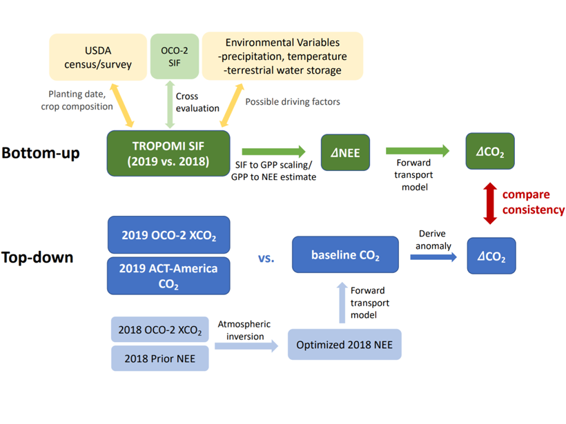
For periods during and following the 2019 spring flood in the U.S. Midwest, Yin et al. [2020] quantified reductions in the usual patterns of crop productivity and its uptake of atmospheric CO2 using two measurements made with satellites: (1) atmospheric CO2 concentrations and (2) the fluorescence (re-emission of the Sun’s light) by leaves of the crops. The two parameters yielded similar carbon flux estimates, thus conferring confidence in the conclusion that regional carbon uptake declined due to the flood.
Although this was a retrospective study of recent months, these satellite data are available in near-real time. Further development and application of these technologies and analyses could enable improved agricultural and ecological forecasting of crop productivity and carbon fluxes, similar to current weather forecasting based on assimilation of atmospheric observations.
Citation: Yin, Y., Byrne, B., Liu, J., Wennberg, P., Davis, K., Magney, T., et al. [2020]. Cropland carbon uptake delayed and reduced by 2019 Midwest floods. AGU Advances, 1, e2019AV000140. https://doi.org/10.1029/2019AV000140
—Eric Davidson, Editor, AGU Advances
Text © 2020. The authors. CC BY-NC-ND 3.0
Except where otherwise noted, images are subject to copyright. Any reuse without express permission from the copyright owner is prohibited.