Editors’ Vox is a blog from AGU’s Publications Department.
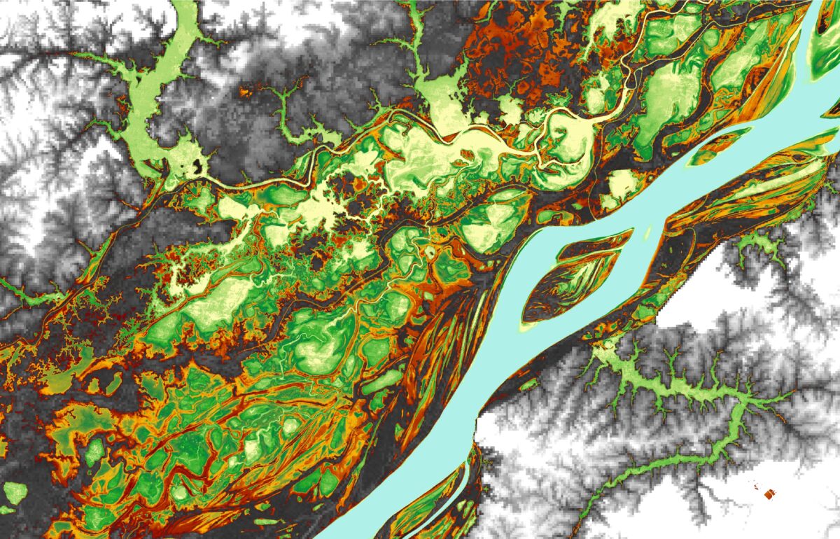
The Amazon Basin is the largest river basin in the world. It covers roughly six million square kilometers, which is about one third of South America. While the sheer scale and difficulty of access makes field observations challenging, remote sensing can provide rich insights. An article recently published in Reviews of Geophysics explores the strengths and limitations of satellite observations of the Amazon basin and makes recommendations for improving these observational systems.
Why is the Amazon so important for hydrologists to study?
The Amazon Basin is notable for its high rates of precipitation, evaporation, and river discharge. The latter represents about 20 percent of the total amount of global fresh water reaching the ocean each year. The Amazon’s hydrology has far-reaching impacts on regional and global climate. For example, the Amazon basin provides moisture to the southern parts of South America. As a large source of heat in the tropics and strong convective processes, it also significantly impacts global atmospheric circulation. Additionally, Amazon surface waters are a major source and sink of carbon dioxide and the largest natural geographic source of methane in the tropics.
What observational tools do scientists use to monitor hydrologic processes in the Amazon basin?
The Amazon basin is a large and remote tropical watershed, mostly covered by dense forest, which makes in situ observations challenging. There are a range of monitoring networks that measure water level and rainfall, as well as flux towers tracking CO2 exchange between the forest and the atmosphere. These networks are essential for scientists to understand hydrological processes but are also limited because of the sheer extent of the basin and the spatio-temporal variability of processes within it. Some phenomena, such as the extent of the flood, are almost impossible to assess in situ.
Remote sensing is a key tool to overcome these limitations because it provides a broader observational viewpoint. Satellite data can be used to estimate a variety of factors including rainfall, evapotranspiration, water level, water surface extent, sediment concentration, topography, and water storage variation over a large area and continuously. Combining both in situ observations with satellite data is a game changer for science.
Combining both in situ observations with satellite data is a game changer for science.
How have advances in satellite-based remote sensing helped researchers better understand the water cycle in the Amazon basin?
Thanks to its characteristics of large rivers and strong hydrological signals, the Amazon basin is an ideal laboratory for the development and evolution of remote sensing techniques. Advances in remote sensing have allowed for the characterization of several hydrological processes in the basin. Two prominent examples are the characterization of orographic rainfall in the Andes region and the estimation of the amount of water stored annually in the Amazon floodplains.
Many remote sensing techniques developed and tested in the Amazon have gone on to be used globally. For example, algorithms for water level estimation from radar altimetry were first evaluated in the wide rivers of the Amazon basin, and the first estimates of the variations of total water storage over the continents by the GRACE satellite, were made for the Amazon.

What are some of the most interesting or dramatic processes or changes in the Amazon observed by satellites?
Examples of interesting processes observed by satellites include: spatial variability of rainfall due to breeze effect that occurs over large bodies of water in the basin; the spatio-temporal variation of sediment concentration in rivers and lakes; the characterization of the complex topography of the floodplain, and the water exchanged between river and floodplain.
Observed trends in hydrological variables that reveal dramatic and recent changes in the basin are also tremendously valuable. For example, there is a trend of increased precipitation in the northern part of the basin, increased discharge, and increased flooded area, thus, flood risks are increasing. The opposite is occurring in the southern region, where there is a trend toward reduced rainfall and discharge. Furthermore, the lengthening of the dry period has increased in recent years, which is generating water stress in tropical forests, making them more vulnerable to die. In addition, anthropogenic influences such as deforestation and mining have caused increases in sediment and nutrient concentration in the rivers.

What are some of the limitations of satellite-based data?
Current limitations of satellite data for the Amazon basin are often related to the space-time resolution, time span, and accuracy. For instance, the use of visible/optical observations, which are very powerful tools, are limited in regions covered with clouds and dense vegetation.
There is also often a trade-off between sampling (how many times the satellite passes over the same point) and spatial coverage (size of the area). For instance, Synthetic Aperture Radar (SAR) techniques show very large capabilities to measure surface water extent at high resolution (10 to 100 meters) but they suffer from a low temporal revisit time, making them unsuitable for monitoring rapid hydrological processes.
Additionally, despite the increasing number of satellite data, it is still necessary to ensure time series long enough to understand and survey the environmental changes in the Amazon.
Also, there are still difficulties in deriving certain geophysical parameters from satellite-based data, such as evapotranspiration. The estimation of evapotranspiration is done indirectly and is parameter dependent, and the current algorithms need to be improved. It is the same for river discharge.
What do you recommend for improving satellite observations of the Amazon basin?
In terms of technical recommendations, we often make suggestions related to the development of new algorithms and data fusion. The recognition of uncertainties in multiple remote sensing data and trade-offs between temporal and spatial resolution point to the need for more integrative approaches. This is the case for mapping long-term flooding and evapotranspiration patterns at high spatio-temporal resolutions. Artificial intelligence will play a major role in future development.
We also believe that a better coupling of Earth Observation datasets with hydrological-hydraulic models and land surface models (such as data assimilation and spatiotemporal interpolation) is also a necessary step forward in Earth System modeling by considering the dynamic aspect of Amazon hydrology.
New hydrology-oriented missions in the coming years, such as the Surface Water and Ocean Topography (SWOT) and ISRO-NASA SAR (NISAR), will provide a new milestone in monitoring Amazon waters from space.
New hydrology-oriented missions in the coming years will provide a new milestone in monitoring Amazon waters from space.
Similarly, nanosatellite constellations have provided the ability to frequently update information about the Earth’s surface, which can make it critical for monitoring the evolution of events such as forest fires and floods but at lower costs than its larger peers.
What are some of the unresolved questions where additional research, data, or modeling are needed?
The Amazon basin is experiencing multiple natural and anthropogenic pressures including from dams, mining, fire, droughts/floods, and deforestation, so there is an urgency to understand how the hydrologic cycle is affected. Despite the recent progress, there are few studies that address these issues and many opportunities for new research.
Remote sensing has the potential to democratize essential and new environmental monitoring tools, moving towards a more sustainable future for the largest basin in the world.
In addition, while Earth Observation through satellites has provided breakthrough scientific advances on the comprehension of the Amazon water cycle recent decades, it is still a challenge to translate knowledge and information from remote sensing into continuous and valuable information and indicators that can assist decision makers to support the Amazon basin’s environmental governance.
Remote sensing has the potential to democratize essential and new environmental monitoring tools, moving towards a more sustainable future for the largest basin in the world.
—Alice Fassoni-Andrade ([email protected],  0000-0002-3233-8781), University of Toulouse, France, and University of Brasília, Brazil; Fabrice Papa ( 0000-0001-6305-6253) University of Toulouse, France, and University of Brasília, Brazil; Rodrigo Paiva ( 0000-0003-2918-6681) Federal University of Rio Grande do Sul, Brazil; Sly Wongchuig ( 0000-0002-1116-0742) University of Grenoble, Alpes, France; and Ayan Fleischmann ( 0000-0002-8547-4736 – Federal University of Rio Grande do Sul, Brazil