It’s difficult to know the exact characteristics of what’s immediately beneath the ground since it’s out of sight and largely inaccessible. A recent article in Reviews of Geophysics describes a new type of analysis that measures the response of groundwater to Earth and atmospheric tides and uses that to infer hydrogeological properties of the subsurface. Here, some of the authors describe developments in this field and their potential applications.
What are Earth and atmospheric tides and how do they affect groundwater?
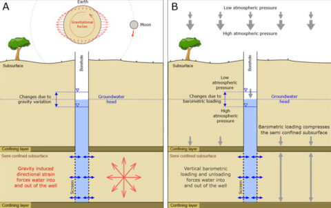
Ocean tides, which are primarily caused by the gravitational pull of the Moon and Sun, are not the only naturally occurring tides on planet Earth. The same celestial movements cause “Earth tides”, which are the shifting of the Earth’s solid surface, and “atmospheric tides”, which are daily oscillations in the troposphere and stratosphere.
Groundwater in the subsurface is affected by these Earth and atmospheric tides, causing changes in groundwater level, albeit on a much smaller scale than the daily rise and fall of sea level. This is because groundwater is required to move through sediments or rock to follow the tides, rather than slosh backwards and forwards freely like water in the ocean.
What can the groundwater’s response to Earth and atmospheric tides tell us about what lies underground?
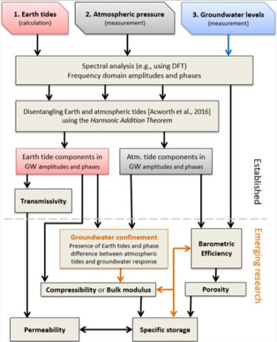
The extent to which the groundwater level changes in response to tidal forces and the time it takes to do so depends on the hydrogeological properties of subsurface materials in any given locality. These include characteristics such as porosity (pore space or volume of water a unit of material can hold), permeability (ability to transport water), storage coefficient (amount of water it can release), and specific storage or specific yield (amount of water that can be released per unit volume).
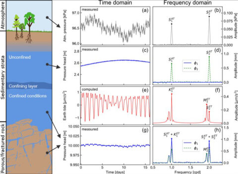
Thus, we can measure tidal changes and groundwater levels and use the relationships to understand subsurface hydrogeological characteristics. This is called Tidal Subsurface Analysis.
What benefits does this kind of analysis offer over other ways to understand the subsurface?
Standard hydrogeological techniques for understanding the subsurface (such as pump tests) require measurements that are intrusive (large pumping bores), require specific infrastructure (pumps and generators) and are expensive to conduct (staff time).
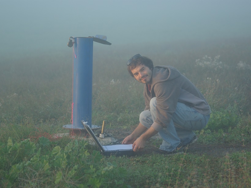
The advantage of measuring the groundwater response to Earth and atmospheric tides is that only passive water level or pressure monitoring and smart analysis is needed to quantify physical properties.
This opens up the opportunity for analysis at many more locations and at a lower cost.
This opens up the opportunity for such analysis to occur at many more locations and also allows us to capture a much more refined picture of the subsurface properties, at a lower cost. It could also enable the tracking of changes in these properties over time as water level monitoring can be done continuously at little expense.
Why are these methods only emerging now?
Separate methods for barometric or earth tide analysis have been available for quite some time as they were pioneered by the United States Geological Survey in the 1960s. However, we believe that they have not been pursued because of the belief that gravity or strain measurements are required in addition to groundwater levels.
Our work has demonstrated two major advances: first, we can use precisely computed Earth tide records instead of expensive gravity measurements; and second, we can now disentangle the influence of Earth and atmospheric tides on groundwater systems, something that has made analysis very difficult in the past.
The prevalence of more multidisciplinary skilled teams has advanced these methods.
Tidal Subsurface Analysis requires knowledge of subsurface poroelasticity. This is standard knowledge in petroleum engineering but not yet among hydrogeologists. The prevalence of more multidisciplinary skilled teams and non-specialist access to computer codes have dramatically increased the accessibility and applicability to advance such methods.
What are some of the applications of Tidal Subsurface Analysis?
Groundwater is the world’s largest freshwater resource and forms the primary water source for billions of people. However, this vital resource is rapidly being depleted, often poorly monitored or quantified, and inadequately managed.
Tidal Subsurface Analysis increases our knowledge of the subsurface and the groundwater resource in both time and space.
Tidal Subsurface Analysis increases our knowledge of the subsurface and the groundwater resource in both time and space.
Thus, we can better predict what will happen when water is extracted from the subsurface and use this knowledge to improve the management of precious groundwater resources.
What are some of the unresolved questions where additional research, data or modeling is needed?
Only a limited number of studies have compared the hydrogeological properties obtained from Tidal Subsurface Analysis with those from traditional investigation techniques, which means that there is limited verification of the method so far.
There is a currently some uncertainty about the area of influence that is being monitored, i.e. are the calculated properties representative of the subsurface at the point of monitoring or for several to tens of meters away from the monitoring point.
In other words, we don’t know how large a volume or area of the subsurface the calculated properties represent. This could be tested using numerical models which, to the best of our knowledge, do not currently exist.
There is, therefore, a big opportunity for further numerical and experimental research to validate and verify the results for a variety of subsurface conditions. This would increase confidence in the accuracy and reliability of Tidal Subsurface Analysis and help establish it as a leading practice technique.
—Timothy McMillan (email: [email protected]), University of New South Wales, Australia; Gabriel Rau, Karlsruhe Institute of Technology, Germany
Citation:
McMillan, T.,Rau, G. (2019), Unlocking a treasure trove for subsurface characterization, Eos, 100, https://doi.org/10.1029/2019EO126909. Published on 12 July 2019.
Text © 2019. The authors. CC BY-NC-ND 3.0
Except where otherwise noted, images are subject to copyright. Any reuse without express permission from the copyright owner is prohibited.