
Floodplains store materials moving downstream and, in doing so, provide habitat for a wide variety organisms. Water, dissolved materials, sediment, and organic matter move downstream, but individual water or solute molecules or sediment grains can be stored on floodplains for periods that range from a few minutes to 10,000 years for sediment on the floodplain of the Amazon River. Storage reflects the strongly three-dimensional movements of materials in a river corridor. Episodic exchanges of water, solutes, sediment, and organic matter between the channel, floodplain, and subsurface create a dynamic environment with diverse habitat. A recent article in Reviews of Geophysics examines the influencing factors and nature of floodplain storage. Here, the author answers our questions about floodplain storage.
What different materials move around and are stored on floodplains?
The main categories of material moving within and stored on floodplains are water, solutes, sediment, and organic matter.
The main categories of material moving within and stored on floodplains are water, solutes, sediment, and organic matter.
Storage of water on floodplains is critical during the extremes of weather: overflow of high water onto a floodplain can reduce the peak flow and limit flood damage, and storage of water in the subsurface of a floodplain can sustain base flow during dry periods.
Among solutes, nutrients such as nitrogen and phosphorus receive a lot of attention, partly because they represent a paradox. Although these elements are necessary to most living organisms, human activities have introduced such large amounts of nitrogen and phosphorus to rivers that the excess now creates severe environmental problems such as eutrophication, or lack of dissolved oxygen in the water that results in fish die-offs.
Contaminants such as heavy metals or synthetic chemicals that attach to silt and clay can also be stored in floodplains, limiting the concentrations of these toxins in the channel.
How does the concept of a “budget” help us to understand inputs, outputs, and storage on a floodplain?
Thinking of a budget that applies over specified time and space scales can help to identify sources and processes that create inputs, outputs, and storage.
The measurements used to create a sediment budget, for example, could help to identify whether a floodplain is losing mass through time (net erosion of sediment) at a rate that might alter the ability of the floodplain to attenuate flood peaks. Or, measurements that quantify sediment inputs and outputs could identify a net gain of sediment through time as a result of upstream changes in land cover or changing climate across the watershed.
A floodplain integrates processes occurring throughout the upstream contributing area and creates a stratigraphic record of these processes. Changes in floodplain budgets over thousands of years can be interpreted from this stratigraphic record, facilitating our ability to infer the associated changes in watershed processes.
What are some of the main natural factors that affect floodplain storage?
Primary natural controls on floodplain storage are the width of the valley floor relative to the width of the channel. Many natural rivers alternate repeatedly downstream between relatively narrow and wider portions of the valley.
The heterogeneity of the floodplain surface and stratigraphy also strongly influence storage. Generally, the more heterogeneous or patchy the floodplain, the greater the storage because the irregular surface and stratigraphy effectively slow the downstream movement of water, solutes, sediment, and organic matter.
The fluxes of material moving down the channel also influence floodplain storage. Some of the sediment moving down a channel with a large sediment flux is more likely to be stored on the floodplain than in a river corridor with very little sediment moving downstream.
How do human activities affect floodplain storage?
Human activities can directly affect floodplain storage by disconnecting the channel and floodplain.
Human activities can directly affect floodplain storage by disconnecting the channel and floodplain.
Artificial levees and flow regulation exemplify human-induced changes that typically limit overbank movement of materials from the channel to the floodplain.
People also change the character of the floodplain via land drainage and groundwater pumping that dry the floodplain and by changing the floodplain land cover through agriculture and urbanization.
Aggregate mining on floodplains not only reduces sediment storage but severely disrupts the movement and storage of other materials on floodplains.
Human activities can increase floodplain storage by introducing larger quantities of solutes or sediment to a river network. Excess nitrogen resulting from fossil-fuel combustion and agricultural fertilizers is sometimes referred to as the nitrate time bomb because, even after nitrate inputs to a river network are reduced, the excess nitrate continues to accumulate at progressively higher levels in floodplain sediments.
Overall, however, human alterations simply and homogenize floodplains and reduce floodplain storage.
What is “floodplain restoration” and why is it needed? Can you give a specific example of a floodplain restoration scheme that improved resilience to natural and human disturbances?
Floodplain restoration involves restoring processes that create and maintain floodplain functions.
Floodplain restoration involves restoring processes that create and maintain floodplain functions, typically by restoring the three-dimensional exchanges of water, solutes, sediment, and organic matter between the channel, floodplain, and subsurface.
Floodplain restoration is needed for at least three reasons. First, floodplain storage reduces downstream hazards associated with floods and excess sediment. Second, fully functional floodplains host high levels of biodiversity and provide ecosystem functions such as clean water. Third, floodplains have not received the legal protection afforded to navigable rivers in the US and other countries.
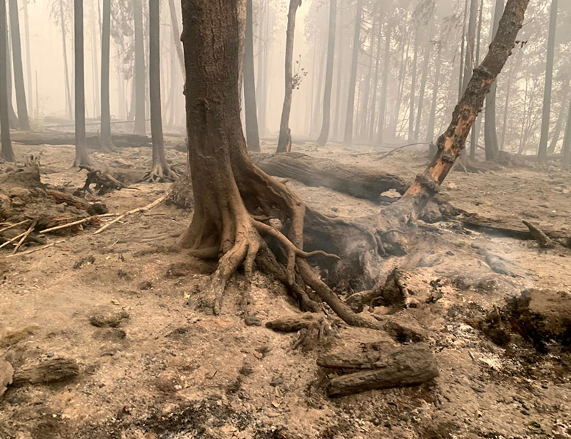
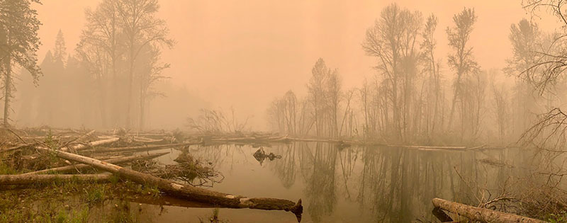
Floodplains are likely to be in private ownership and to be heavily altered by agriculture and urbanization; consequently, they are endangered ecosystems. Ongoing river restoration at the South Fork McKenzie River in Oregon, USA has reconnected the channel and floodplain. When the Holiday Farm fire burned through the area in 2020, the presence of water on the newly reconnected floodplain decreased the burn severity in the restoration area.
What are some of the unresolved questions where additional research, data, or modeling is needed?
We have made good progress in measuring and modeling some of the processes involved in floodplain storage, especially for surface water and sediment, but there are huge discrepancies between our understanding of surface water and sediment dynamics and our understanding of subsurface water, solute, and organic matter inputs, outputs, and storage.
Because our understanding of the movements of these latter materials is limited, we cannot yet integratively model how subsurface water, solutes, microbial communities, and organic matter, for example, interact within a floodplain over diverse scales of time and space. The ability to develop this type of model would be ideal for predicting floodplain response to restoration.
In the meantime, treating floodplain restoration projects as experiments that are monitored and used to gain understanding that can inform future restoration is critical.
—Ellen Wohl ([email protected], ![]() 0000-0001-7435-5013), Colorado State University, USA
0000-0001-7435-5013), Colorado State University, USA
Citation:
Wohl, E. (2021), Why rivers need their floodplains, Eos, 102, https://doi.org/10.1029/2021EO156786. Published on 22 April 2021.
Text © 2021. The authors. CC BY-NC-ND 3.0
Except where otherwise noted, images are subject to copyright. Any reuse without express permission from the copyright owner is prohibited.