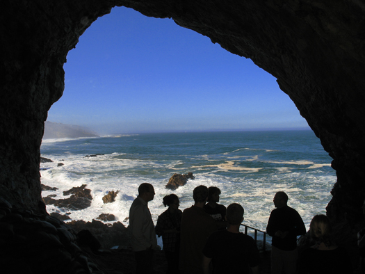
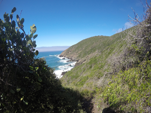
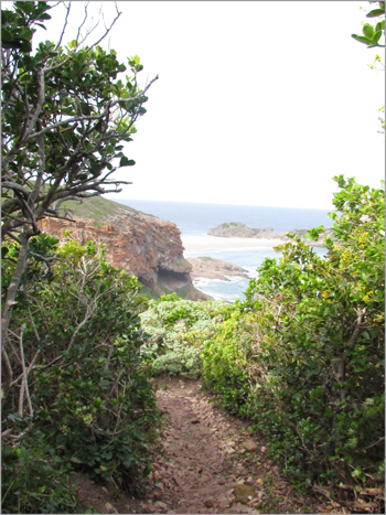
Southern South Africa is well known for its scenic coastline of rugged cliffs and long, sandy beaches and for its fynbos, an extraordinarily diverse, Mediterranean-type assemblage of shrubs and other vegetation, most of which are endemic to the area. The region is also known for its long legacy of human inhabitation. Today it is home to numerous coastal communities interspersed among large population centers like Cape Town and Port Elizabeth, but the present-day coastline is also dotted with archaeological sites documenting 200,000 years of human activity.
For much of the past 200,000 years, the ocean was substantially lower than it is today, and the view from the caves and rock shelters that once hosted humans would have been quite different.
These sites sit along the northern edge of the Paleo-Agulhas Plain, a piece of continental shelf the size of Ireland that was repeatedly exposed and submerged as sea levels changed through the Pleistocene and that today lies beneath the waves south of Africa. Scientists have long recognized that the Paleo-Agulhas Plain was an important part of the glacial landscapes—and one that shaped human populations—in southern Africa, but the environment and ecology of the plain have been largely unknown. That’s changing, however, as researchers apply advanced methods and reveal archaeological and geological records that tell tales of feast, famine, and migration as the coastline advanced and retreated over many millennia.
Revealing Ancient Vistas
The highest sea levels were about 6 meters above the present level during the last interglacial phase, about 125,000 years ago, whereas the lowest were 129 meters below present levels during the penultimate glacial period, roughly 137,000 years ago. For much of the past 200,000 years, the ocean was substantially lower than it is today, and the view from the caves and rock shelters that once hosted humans would have been quite different.
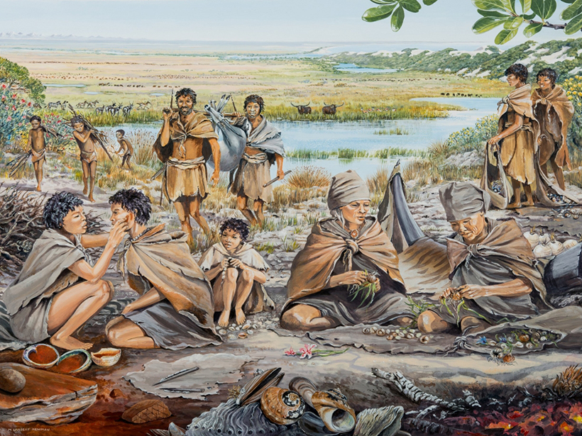
Near the caves, inhabitants would have looked out over a wide, mostly flat plain resembling the grasslands of modern eastern Africa more than the fynbos shrublands of the current coastal lowlands. The ancient grasslands were dissected by rivers that flowed south from the mountains of the Cape Fold Belt and had wide floodplains covered in woodlands and lush wetland vegetation [Cowling et al., 2020].
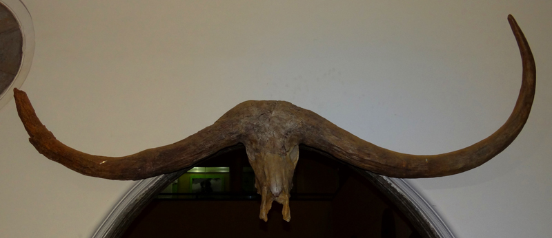
Diverse herbivores roamed the grasslands, woodlands, and wetlands in large herds [Marean et al., 2020]. Large grazers, like the now extinct giant buffalo, whose curving horns protruded a meter from either side of its head, remained in the open grasslands, whereas zebra, wildebeest, blue antelope, and hartebeest took advantage of the open grasslands and tall wetland grasses. Browsers like giraffe, black rhino, bushbuck, and kudu, as well as mixed browser–grazers like springbok and eland, preferred the more closed habitats of the floodplains. The wetlands and rivers provided a home for reedbucks, hippos, and Nile crocodiles.
On the Paleo-Agulhas Plain, fynbos shrublands were found mostly on the outer shelf at the height of glacial periods when sea levels were more than 100 meters below where they are today. These plant communities were specifically adapted to the limestone substrate of what’s now the deeper continental shelf. The repeated flooding and exposure of the Paleo-Agulhas Plain left a legacy of coastal dune deposits scattered across the landscape. Outcrops of these dunes cemented by carbonates were interspersed with the grasslands on the plain and covered by mosaics of fynbos and subtropical thicket vegetation. These vegetation types supported the less diverse and less numerous large mammal communities that are also present on the current coastal lowlands, namely, grysbok and bush duiker [Marean et al., 2020]. Elephants moved between the different habitats on the plain and farther inland, where today’s coast is.
Revealing the environments of the Paleo-Agulhas Plain is part of an ongoing transdisciplinary collaboration including researchers from South Africa, the United States, and Australia [Cleghorn et al., 2020]. The effort began with scientists, including myself, reconstructing the physical environment of this region: its geology, soils, and climate and the dynamic effects of sea level changes. Collaborators then mapped vegetation distributions and large mammal habitats on the basis of the physical environment.
Local scientists recruited descendants of local coastal Khoisan tribes for modern foraging experiments because of their experience in marine foraging for personal consumption.
Local scientists recruited descendants of ancestral coastal Khoisan tribes for modern foraging experiments because of their experience in marine foraging for personal consumption. In these experiments, the tribespeople harvested shellfish and plant foods in previously defined coastal marine habitats and fynbos plant communities. By recording the amount of food harvested by each person in a defined amount of time, each shellfish habitat and plant community could be assigned an average “return rate.” For marine foraging, the main driving factors of return rates were tides, weather conditions, and coastal habitat type [De Vynck et al., 2016]. Plant foraging experiments showed that food resources were unevenly distributed and that hunter–gatherers would have profited from detailed knowledge of the locations of calorie-dense resource “hot spots” [Botha et al., 2020].
We integrated these results with knowledge about the distributions of vegetation and other resources, such as raw materials for stone tools, to produce a resource landscape that informs computational modeling efforts to simulate the behaviors of people on the landscape.
Modeling Climate and Mapping Vegetation
Environmental changes during and between glacial and interglacial periods had profound impacts on the Paleo-Agulhas Plain and its surroundings. The most significant were from sea level variations, which exposed and submerged the plain twice in the past 200,000 years [Fisher et al., 2010].
The climate, on the other hand, seems to have remained stable along the present-day southern coast compared with climates in the southern African interior. Paleoclimate modeling of conditions at the Last Glacial Maximum (LGM), roughly 21,000 years ago, suggests only mild temperature decreases over the Paleo-Agulhas Plain and along the present-day southern coast [Engelbrecht et al., 2019].
The grasslands and floodplain vegetation on the exposed Paleo-Agulhas Plain comprised a set of habitats that are now almost completely absent from the region.
This modeling also showed only small changes in annual rainfall amounts along the southern coast, although the seasonality of rainfall has varied considerably. Most of South Africa and the Paleo-Agulhas Plain received more winter rainfall during the last glacial period than they do today because of a northward shift of the westerly wind belt [Engelbrecht et al., 2019]. The prevailing westerly and northwesterly winds brought about by this shift led to downwind effects along the southern flanks of the Cape Fold Mountains and the present-day central southern coast that reduced winter rainfall [Engelbrecht et al., 2019].
Researchers mapped the vegetation from 26,000–19,000 years ago, around the time of the LGM, using field data on the distributions of geological and soil substrates combined with paleoclimate modeling [Cowling et al., 2020]. Because the vegetation that grows in an area depends strongly on the underlying bedrock and soil, which typically remain stable over long periods of time, the vegetation on the present coastal lowlands has not changed considerably since the LGM. The grasslands and floodplain vegetation on the exposed Paleo-Agulhas Plain, however, comprised a set of habitats that are now almost completely absent from the region [Marean et al., 2020].
Reconstruction by Proxy
A range of proxy methods provides independent reconstructions of past climate and vegetation in the region, with results that can be compared with model outputs and map projections. For example, colleagues and I determined ratios of the stable isotopes of oxygen (16O and 18O) preserved over millennia in stalactites and stalagmites from coastal caves to track changes of rainfall seasonality from 113,000 to 19,000 years ago [Braun et al., 2020].
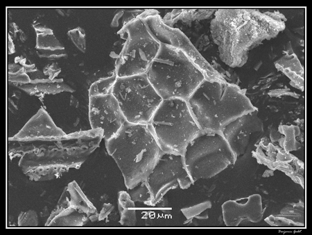
Carbon stable isotope ratios (12C and 13C ) from the same stalactites and stalagmites, as well as in fossil mammal teeth and ostrich eggshells, can yield information about the abundance of tropical grasses (which use the C4, or Hatch-Slack, carbon dioxide fixation cycle) versus shrubs, trees, and temperate-region herbs and grasses (which use the C3, or Calvin, cycle) growing in the soil above the coastal caves and in the animals’ diets. Phytoliths, microscopic silica particles produced in different characteristic shapes and sizes in plant cells, are also useful as a proxy for the abundance of tropical C4 grasses compared with C3 trees, shrubs, and temperate-region grasses [Esteban et al., 2017]. They are commonly found in the sedimentary sequences of archaeological sites.
Stable carbon isotope analyses of large mammal teeth from the LGM indicate that at Nelson Bay Cave, near Plettenberg Bay on the current southeastern coast, grazers mainly ate C3 grasses that grew there when winter rainfall was prevalent [Sealy et al., 2020]. This observation is supported by the paleoclimate model, which predicts that winter rainfall dominated the Paleo-Agulhas Plain near Nelson Bay Cave at this time [Engelbrecht et al., 2019].
Several proxy records gathered along the central southern coast in the area surrounding Pinnacle Point near Mossel Bay offer information about an earlier cool phase known as marine isotope stage (MIS) 4, which lasted from about 72,000 to 59,000 years ago. Oxygen and carbon stable isotopic ratios measured in stalactites and stalagmites suggest that summer rainfall increased and more C4 grasses grew during this cool phase than during warmer periods [Braun et al., 2020]. Carbon isotopic ratios in large grazer teeth and ostrich eggshells, as well as phytolith assemblages, support the hypothesis that C4 grasses were more common during MIS 4, although ratios detected in small mammals (mostly vlei rats) suggest that C3 plants were also still abundant in the vicinity of Pinnacle Point.
The archaeological sites where humans dwelt long ago were positioned in a transition zone between two ecological realms.
The proxy results suggest that conditions downwind of the Cape Fold Belt were similar during MIS 4 to those indicated by paleoclimate modeling for the LGM. This work thus highlights that the archaeological sites where humans dwelt long ago were positioned in a transition zone between two ecological realms: the fynbos farther onshore, which was dominated by C3 plants, and the grasslands of the Paleo-Agulhas Plain, with their high abundances of C4 grasses.
Changes to the Menu
Finding food and water would have occupied much of the time for hunter-gatherers. Water was readily available on the Paleo-Agulhas Plain in the closely spaced rivers and wetlands and from groundwater seeps [Marean et al., 2020]. Locating food resources in the region would have mainly involved foraging for plant foods, gathering shellfish, and hunting large mammals, but the availability of each of these changed through time.
Fynbos vegetation is very rich in plants that produce bulbs and tubers, but not all of them are palatable, and some are even poisonous. Food resources amid the fynbos are clustered in specific vegetation types and in areas recently affected by wildfires [Botha et al., 2020], which trigger seed sprouting in some plants. Skilled gatherers with knowledge of edible plants and where and when they cluster would have been able to gather plenty of food, and they may even have set wildfires to increase supplies [Botha et al., 2020].
Fynbos plant communities near the present-day coast have not changed much since the LGM, but the Paleo-Agulhas Plain, when it was exposed, offered substantial areas with mosaics of fynbos and thicket vegetation [Cowling et al., 2020], which can be especially productive for foraging, in part because of the softer soil, which makes it easier to dig up bulbs [Botha et al., 2020]. Although fynbos vegetation was widespread during the LGM, the efficiency of plant foraging may have been limited compared with foraging during interglacials because individual bulbs would have been smaller with the lower concentrations of carbon dioxide in the air (a minimum of about 180 parts per million, compared with about 290 before the Industrial Revolution and 400 today) [Faltein et al., 2020].
Hunting expeditions likely would have been more productive on the Paleo-Agulhas Plain than on the present coastal lowlands because populations of large mammal faunas were denser amid grasslands and floodplains of the plain than in the fynbos. Sea level changes, however, considerably affected the size of large-mammal habitats, with only small remnants of grasslands remaining during full interglacials when sea levels were high.
Archaeological records from the Holocene—an interglacial beginning about 12,000 years ago—across the region suggest that people did, in fact, hunt fewer of the animals associated with the habitats on the Paleo-Agulhas Plain, probably because these species were less abundant or went extinct. Archaeological assemblages from interglacial MIS 5 (~128,000–72,000 years ago), however, suggest that habitat loss did not cause local extinctions of grassland species; rather, they survived as refugee species in decreased numbers.
These assemblages also show that shellfish like mussels and snails were a reliable and productive source of protein for hunter–gatherer diets at times. Shellfish are more perishable than larger animals, so early humans probably gathered only what they could eat the same day. The coast was within the 10-kilometer daily foraging radius from the cave dwellings on what is now the central southern coast when the sea level was less than 60 meters below the present level [Fisher et al., 2010].
Lower-than-present sea levels meant that rocky shores were absent and sandy beaches, interspersed with reefs of cemented dunes, were much more common. In the present-day foraging experiments, these reefs yielded high returns of shellfish when tides and weather were favorable, but returns were very low on beaches [De Vynck et al., 2016]. The common occurrence of sand mussels in archaeological shell middens, however, suggests that Pleistocene hunter-gatherers foraged effectively on beaches nonetheless.
A Picture of the Past
The resource landscape developed for hunter-gatherers provides the natural boundary conditions for an agent-based computational model that simulates the movement of people on the landscape. An initial model representing interglacial conditions suggests that in the absence of the abundant large-mammal fauna on the Paleo-Agulhas Plain, people were heavily dependent on plant foraging and exploited marine resources when possible. Overall, the viable population density was only two people per 100 square kilometers, similar to that of today’s Montana or Wyoming [Wren et al., 2020].
During intermediate conditions and glacials, the resource landscape would have looked quite different. At intermediate sea levels, people were still able to access coastal resources and forage for fynbos plants, while the Paleo-Agulhas Plain provided more game for hunting. In glacial phases, marine resources would have been out of reach for people living on the present-day coast. During these periods, fynbos plant communities, although still abundant, may have provided less food. It is thus likely that during these times, people relied heavily on hunting large mammals of the Paleo-Agulhas Plain.
As a result of the collection of research described here—and of the large, transdisciplinary collaboration, which has allowed us to resolve far-reaching and comprehensive questions—we now know that the Paleo-Agulhas Plain was far more than an extension of the coastal lowlands of today’s southern African coast. Rather, the plain was its own unique ecosystem, affected by exceptional dynamic changes of climate and exposure on glacial–interglacial timescales. These dynamics, in turn, shaped habitats for vegetation, animals, and our human hunter–gatherer ancestors, for whom the plain represented the most productive foraging environment in the region—and one that helped sustain them for tens of thousands of years.
References
Botha, M. S., et al. (2020), Return rates from plant foraging on the Cape south coast: Understanding early human economies, Quat. Sci. Rev., 235, 106129, https://doi.org/10.1016/j.quascirev.2019.106129.
Braun, K., et al. (2020), Comparison of climate and environment on the edge of the Palaeo-Agulhas Plain to the Little Karoo (South Africa) in marine isotope stages 5–3 as indicated by speleothems, Quat. Sci. Rev., 235, 105803, https://doi.org/10.1016/j.quascirev.2019.06.025.
Cleghorn, N., A. J. Potts, and H. C. Cawthra (2020), The Palaeo-Agulhas Plain: A lost world and extinct ecosystem, Quat. Sci. Rev., 235, 106308, https://doi.org/10.1016/j.quascirev.2020.106308.
Cowling, R. M., et al. (2020), Describing a drowned ecosystem: Last Glacial Maximum vegetation reconstruction of the Palaeo-Agulhas Plain, Quat. Sci. Rev., 235, 105866, https://doi.org/10.1016/j.quascirev.2019.105866.
De Vynck, J. C., et al. (2016), Return rates from intertidal foraging from Blombos Cave to Pinnacle Point: Understanding early human economies, J. Hum. Evol., 92, 101–115, https://doi.org/10.1016/j.jhevol.2016.01.008.
Engelbrecht, F. A., et al. (2019), Downscaling Last Glacial Maximum climate over southern Africa, Quat. Sci. Rev., 226, 105879, https://doi.org/10.1016/j.quascirev.2019.105879.
Esteban, I., et al. (2017), Phytoliths in plants from the south coast of the Greater Cape Floristic Region (South Africa), Rev. Palaeobot. Palynol., 245, 69–84, https://doi.org/10.1016/j.revpalbo.2017.05.001.
Faltein, Z., et al. (2020), Atmospheric CO2 concentrations restrict the growth of Oxalis pes-caprae bulbs used by human inhabitants of the Paleo-Agulhas Plain during the Pleistocene glacials, Quat. Sci. Rev., 235, 105731, https://doi.org/10.1016/j.quascirev.2019.04.017.
Fisher, E. C., et al. (2010), Middle and late Pleistocene paleoscape modeling along the southern coast of South Africa, Quat. Sci. Rev., 29, 1,382–1,398, https://doi.org/10.1016/j.quascirev.2010.01.015.
Marean, C. W., R. M. Cowling, and J. Franklin (2020), The Palaeo-Agulhas Plain: Temporal and spatial variation in an extraordinary extinct ecosystem of the Pleistocene of the Cape Floristic Region, Quat. Sci. Rev., 235, 106161, https://doi.org/10.1016/j.quascirev.2019.106161.
Sealy, J. C., et al. (2020), Climate and ecology of the Palaeo-Agulhas Plain from stable carbon and oxygen isotopes in bovid tooth enamel from Nelson Bay Cave, South Africa, Quat. Sci. Rev., 235, 105974, https://doi.org/10.1016/j.quascirev.2019.105974.
Wren, C. D., et al. (2020), The foraging potential of the Holocene Cape south coast of South Africa without the Palaeo-Agulhas Plain, Quat. Sci. Rev., 235, 105789, https://doi.org/10.1016/j.quascirev.2019.06.012.
Author Information
Kerstin Braun ([email protected]), Institute of Human Origins, Arizona State University, Tempe
Citation:
Braun, K. (2020), A lost haven for early modern humans, Eos, 101, https://doi.org/10.1029/2020EO150529. Published on 14 October 2020.
Text © 2020. The authors. CC BY-NC-ND 3.0
Except where otherwise noted, images are subject to copyright. Any reuse without express permission from the copyright owner is prohibited.