Thwaites Glacier is not stable. In fact, it is one of the most rapidly changing glaciers in Antarctica, melting at roughly twice the rate it did in the mid-1990s. And in January, scientists confirmed a dire prediction: The water underneath the glacier is currently two degrees above the freezing point.
Thwaites is a tongue of frozen water that flows from West Antarctica through a passage about 120 kilometers wide into the Amundsen Sea. Covering about 190,000 square kilometers, larger than the state of Florida, Thwaites is one of the most expansive glaciers on the continent and holds enough water to raise global sea level by more than half a meter. As with other glaciers and ice sheets worldwide, the increased melting at Thwaites is largely a response to rising air and water temperatures. But the details of why Thwaites is losing ice so fast, and what this loss might portend for West Antarctica—and for communities around the world forced to confront rising seas—are unclear.
Answering these questions is a core motivation for scientists participating in a multiyear U.S.–U.K. research initiative called the International Thwaites Glacier Collaboration (ITGC), which got under way in late 2018 and is now completing its second of four austral summer field seasons. The goal of the ITGC, funded with roughly $50 million from the U.S. National Science Foundation and the United Kingdom’s Natural Environment Research Council, is to diagnose the glacier’s health and learn more about its history. Using data collected through the collaboration, hundreds of researchers will look at Thwaites from numerous angles, studying the ice, the surrounding ocean and atmosphere, and the bedrock beneath the glacier.
This information will allow scientists to build improved models of Thwaites’s future evolution and its likely impact on sea level rise, key tools for future mitigation and adaptation efforts.
Getting to Thwaites

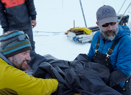
Thwaites is remote. Situated at the center of the West Antarctic Ice Sheet (WAIS), a gigantic ice mass slightly larger than the state of Alaska, the glacier stretches from hundreds of kilometers inland to the seaward edge of the ice sheet, where it discharges icebergs and meltwater. Research sites on Thwaites are more than 1,600 kilometers from the United States Antarctic Program’s McMurdo Station and the British Rothera Research Station. Getting to these sites requires a 4-day trip by boat or several hours of flight and refueling stops from either of these outposts.
“Both nations felt like they had to team up in order to be able to put [forward] the kinds of resources…and the amount of equipment and gear and fuel that are needed to really explore this very large but very remote glacier in Antarctica,” said Ted Scambos, a senior research scientist at the Cooperative Institute for Research in Environmental Sciences in Boulder, Colo., and lead American scientific coordinator for the ITGC.
As important as Thwaites is individually, it may also be a linchpin for accelerated ice sheet collapse and melting on a much broader scale.
Despite its remoteness, researchers have flagged Thwaites as a scientific priority. It already contributes roughly 4% to the global sea level rise rate, currently 3.4 millimeters per year, and recent simulations suggest that it could start collapsing very quickly, within as little as 200 years, potentially adding at least 1 additional millimeter every year. Moreover, airborne and satellite observations have revealed that a huge cavity—two thirds the size of Manhattan Island and roughly 300 meters tall—is forming beneath the glacier, vacating a volume within the past 3 years that would have held 14 billion tons of ice.
Given its position amid the WAIS, were Thwaites to disappear, it could also hasten the demise of surrounding parts of the ice sheet that it helps buttress. In short, as important as Thwaites is individually, it may also be a linchpin for accelerated ice sheet collapse and melting on a much broader scale. But without a better understanding of the glacier’s past, present, and potential futures, it’s difficult to tell how the entire WAIS might respond to changes in Thwaites.
Unstable Pancake Batter
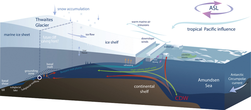
One of the reasons why Thwaites Glacier is potentially unstable is the great depth of the underlying bedrock below sea level. Glaciers flow under their own weight, slowed by floating ice shelves, which act like dams for the grounded ice sheets behind, and by friction between grounded ice and the rock beneath. As Thwaites loses mass—from above and below—its ice shelf faces a greater risk of failing. In addition, the weight holding the ice sheet against bedrock lightens and ocean water can get below the ice more easily, reducing the friction and allowing the glacier to flow more freely into the ocean.
Typically, glaciers behave “like pancake batter on a frying pan,” Scambos said. If you put a big blob of it on the surface it settles from the top toward the edge. “But what you get in West Antarctica is a situation where the pancake batter is on an oiled frying pan, so [the whole blob] slides over the frying pan rather than just deforming under its own weight.”
If Thwaites starts thinning and flowing faster, it may begin calving—or losing large pieces of ice—at a faster rate, potentially getting into a runaway situation called marine ice sheet instability. In this scenario, the glacier’s grounding line, the edge where the bottom of the ice is in contact with bedrock, retreats due to warming and the loss of ice mass. While the current grounding line is 600 meters below sea level, the bedrock farther inland is even deeper, so as the grounding line retreats, a thicker portion of the glacier will be afloat—and flow even faster under its own weight.
A waning Thwaites could also suffer from another disruptive process known as marine ice cliff instability. Previous research has suggested that ice cliffs more than about 100 meters tall are inherently unstable and can collapse under their own weight, calving off as large icebergs (although other work has questioned the potential significance of this process for Antarctic glaciers). This process could accelerate as the edge of a glacier retreats inland into thicker parts of the ice, allowing taller cliffs to form.
“We are in for sea level rise anyway because the Earth is getting warmer,” Scambos said. “But if we add this wild card on top of it, we could see [sea level rise] become much more problematic, and the rate of sea level rise would become more difficult to manage.”
Holes in the Ice
The ITGC is divided into eight individual research projects, each devoted to studying specific scientific aspects of Thwaites Glacier and its environment. Four of the projects are looking at the natural processes that drive the glacier’s retreat and its response to warming temperatures. Two are focused on unraveling Thwaites’s past evolution. And two more will use what the others learn to refine numerical models that predict the glacier’s future behavior.
Warmer water reaching the Antarctic coast is a major factor in the accelerated melting of Thwaites and neighboring glaciers. Changes in ocean circulation driven by shifting wind patterns—which are in turn thought to be driven by changes in distant tropical circulation—are pushing relatively warm, salty water known as Circumpolar Deep Water toward the continent from its usual location beyond the continental shelf. This warm water circulates beneath and melts the Thwaites ice shelf, the floating portion of the glacier seaward of the grounding line. For this reason, the work of many of the ITGC scientists in the field involves drilling through the ice to reach the ocean water below the ice shelf.
“We are interested in learning the temperature of the ocean water at the grounding line of the glacier,” said David Holland last fall as his team prepared to head south for the season. Holland is a physical climate scientist at New York University and a principal investigator on the Melting at Thwaites grounding zone and its control on seal level (MELT) project. “We will be looking at the amount of turbulence present in the water and how vigorously it causes melting of the base of the glacier.”
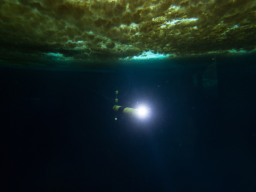
During the 2019–2020 field season, Holland and his team used a hot-water drill to bore 40-centimeter-wide hole through 600 meters of ice at the Thwaites grounding zone to reach the water below. It’s hazardous work. “The access hole, once drilled through, is continually freezing back in and from time to time needs to be reamed,” Holland explained. “We have to be very careful around it not to slip and fall.”
Holland and his team used these holes to introduce sensors through the ice, including a state-of-the-art underwater robot known as Icefin that can explore the subsurface for several hours on each dive. Icefin can measure conductivity, temperature, depth, and dissolved oxygen, and it packs, among other instruments, a camera and an echo sounder for imaging its environment. They also deployed ocean moorings off the coast, submerged sensors that will monitor ocean conditions for over a year.
Icefin’s measurements have now reported that the water at the grounding line is two degrees above the freezing point. “That is really, really bad,” Holland told the Washington Post on 30 January when the team announced the findings. “That’s not a sustainable situation for that glacier.”

Scientists on the Thwaites–Amundsen Regional Survey and Network Integrating Atmosphere–Ice–Ocean Processes (TARSAN) project also drilled through the ice. They installed sensors at three locations in the water below the ice shelf, connected to surface stations by wires left to freeze in place as the holes close. These stations relay sensor measurements remotely to the researchers, who will monitor water temperature and circulation below the ice shelf to determine how currents change throughout the year. They are particularly interested in studying so-called polar water, a cool, low-salinity water layer that forms in direct contact with the bottom of the glacial ice. This layer could be disturbed by warm water coming from the ocean. “If we don’t see a polar water layer there, then it means the ice is melting very fast,” said Scambos, who is also a member of the TARSAN project.
A Glacier History Lesson
Understanding how Thwaites Glacier has responded to past climate variation could tell researchers what to expect in the future.
The goal of the Thwaites Offshore Research (THOR) project is to uncover Thwaites’s past from tracks that the glacier has scoured into the seafloor. Working from the R/V Nathaniel B. Palmer, an icebreaker operated by the United States Antarctic Program, THOR scientists are mapping and recovering sediment cores from the seafloor in front of Thwaites. They embarked on a first cruise in early 2019, and the 2020 expedition is scheduled to end on 25 March.
“We had great success last year because a lot of the landfast ice in front of Thwaites broke out from areas that have never been accessible before by ship, and we were able to extend the survey into areas we didn’t expect to be able to go,” said Robert Larter, a marine geophysicist with the British Antarctic Survey and a principal investigator on the THOR project.
If researchers find that the glacier has regrown from a partially retreated state, it might indicate that it could recover again in the future.
“In these survey data, you can see features that record where the grounding line of the glacier would stabilize during periods in the past,” Larter said. “So you can see these points, and you can see how [the glacier] stepped back, and see things that tell you about how the glacier was interacting with the bed and what the flow processes were.”
The sediment cores allow scientists to date these events. “One thing we can look at [in the sediments] is when the contemporary retreat really started,” Larter said.
Another important question regarding Thwaites’s past is whether the glacier has ever retreated beyond its current grounding zone. It’s been widely believed by scientists that Antarctic glaciers have slowly receded since the Last Glacial Maximum, about 20,000 years ago, although recent evidence suggests that they might have regained some ground in the past 5,000 or so years.
Finding that out is the goal of the Geological History Constraints on the Magnitude of Grounding-Line Retreat in the Thwaites Glacier System (GHC) project. If researchers find that the glacier has regrown from a partially retreated state, it might indicate that it could recover again in the future. “Essentially, the question is, If it retreats, is it always going to be in a retreated state until the next ice age, whenever that may be?” said Brent Goehring, a geologist at Tulane University in New Orleans, La., and a co–principal investigator on GHC.
Goehring and his team spent the 2019–2020 field season drilling through the ice near the margins of Thwaites glacier at its grounding zone with a portable drill used for mining exploration. Their goal was to reach shallow, volcanically formed subglacial ridges that might have been exposed to the atmosphere if the glacier retreated from its current position at some point in the past 20,000 years.
To determine whether these rocks have been above the ice level during that period, they are looking for the effects of cosmic rays, high-energy particles that constantly bombard Earth’s surface from space. Cosmic rays can alter surface rocks, loading them with radioactive isotopes such as carbon-14 that scientists can measure to date when the rocks were previously exposed to the atmosphere.

If the researchers find that the ridges were above the ice at some point since the last glaciation, they can link the timing of this exposure to the sea level and climatic conditions of that time. This information will be crucial to understanding how Thwaites and other Antarctic glaciers have responded to past environmental variations.
Joanne Johnson, a geologist with the British Antarctic Survey, is the other co–principal investigator for GHC. In December 2019, she led a four-person party through the Hudson Mountains, near Pine Island Glacier just east of Thwaites, using ground-penetrating radar and sampling rocks to look for suitable drilling sites for the 2020–2021 season.
The GHC researchers must drill through 10–80 meters of ice before reaching bedrock. “Drilling into bedrock under ice is challenging,” Johnson said. “In the worst-case scenario, we might not be able to recover any core! Then we might hit rock that is not what we thought it would be.”
If they can recover viable rock samples, exposure dating them is no easy task either, because measuring carbon-14 in the sort of volcanic rocks that form the ridges below Thwaites is complex and not routinely done, Johnson explained. “It will also be hard working with the very small amounts of rock core that we will recover—the core diameter is about 5 centimeters, so there is not a lot of rock to work with for the people in the lab,” she said.
Sobering Science
The ITGC is one of the largest Antarctic research collaborations between the United States and the United Kingdom ever attempted, and it’s full of challenges for researchers and their equipment.
“The whole [of the] glaciology and oceanographic communities [is] clearly challenged…by understanding [Thwaites], and challenged by the environment,” Scambos said. “We are talking about drilling through the ice and then setting instruments in the ocean below the ice and having them operate for 2 or 3 years on their own. That’s also a huge engineering challenge.”
“We were spending whole weeks in areas where no ship had ever been before, collecting brand-new surveys of the seafloor and sediment cores.”
Researchers hope that all the effort will yield improved knowledge of Thwaites Glacier. “Hopefully the ITGC will help us fill in pieces of the puzzle so that we can more accurately describe what could happen in the future to this glacier and to global sea level,” Holland said.
In addition to the personally demanding and risky frontier scientific work they are doing, ITGC researchers also worry about what the outcomes of their work could indicate about Earth’s future. “There is still a lot we don’t know, but this program will undoubtedly change that,” Johnson said. “I went to the same sites back in 2006, so I am very excited to see the area again and see how it has changed,” she said. “Probably I should not be excited about this, though, because the changes are likely to be bad news for the ice sheet’s future.”
In a recent review article, Ted Scambos and colleagues articulated the overarching questions very clearly, Larter noted: How much and how fast is Thwaites going to contribute to sea level rise? During the 2018–2019 field season, “we were spending whole weeks in areas where no ship had ever been before, collecting brand-new surveys of the seafloor and sediment cores,” Larter said. “It’s all new science, but it’s also sobering to think about why you’re able to be there—the very fact that it’s a sign of the changes that are going on.”
Author Information
Javier Barbuzano ([email protected]; @javibarbuzano), Science Writer
Citation:
Barbuzano, J. (2020), Diagnosing Thwaites, Eos, 101, https://doi.org/10.1029/2020EO139694. Published on 31 January 2020.
Text © 2020. The authors. CC BY-NC-ND 3.0
Except where otherwise noted, images are subject to copyright. Any reuse without express permission from the copyright owner is prohibited.