Many developing nations in earthquake-prone areas confront a tough problem: How much of their limited resources should they use to mitigate earthquake hazards? This decision is difficult because major earthquakes are infrequent, and it is unclear when one may happen, how big it could be, and how much harm it may cause. Moreover, these nations have profound immediate needs, including such ongoing rapid transformations as urbanization.
Tough societal challenges for which crucial information is missing and proposed solutions involve complex interactions with other issues are called “wicked” problems [Rittel and Webber, 1973]. These contrast with “tame” problems in which necessary information is available and solutions, even if difficult and expensive, are straightforward to identify and execute.
A close look at issues involved with mitigating earthquake risk in Bangladesh illustrates what researchers and disaster managers can do address wicked problems in disaster management. The examination shows that wicked problems, despite their complexity, can be approached with strategies that should reduce vulnerabilities and potentially save lives.
Wicked or Tame?
Updating the United States’ aging infrastructure is a tame problem because what is wrong and how to fix it are clear. In contrast, addressing climate change is a wicked problem because its effects are uncertain and the best strategies to address them are unclear [Stang and Ujvari, 2015].
Natural hazard problems can be tame or wicked. Earthquake hazard mitigation for San Francisco is a relatively tame problem. Studies of regional geology and past earthquakes have been used to infer shaking in future earthquakes and develop mitigation approaches, including codes for earthquake-resistant construction. The population is affluent and aware enough to accept these measures, although financing and carrying out these measures is still challenging.
In contrast, earthquake hazard mitigation in Bangladesh and its surroundings is a wicked problem (Figure 1). Bangladesh is the world’s most densely populated nation, with 160 million people, approximately half the U.S. population, crowded into an area the size of Iowa. The region lies on the boundary between plates whose collision uplifts the Himalayas, but complex geology and sparse data make it difficult to assess earthquake hazard. Thus, it is difficult to decide how much of the limited resources available should be used for earthquake hazard mitigation, given other more immediate needs.
For example, 31% of Bangladeshis live below the national poverty line, according to data from 2010. Per capita gross domestic product is only about $1,200, so Bangladesh needs to devote resources to economic growth. Bangladesh also needs resources to address challenges resulting from the nation’s low elevation. Almost half the population lives within 10 meters of sea level, so the country is very vulnerable to tropical cyclones, riverine flooding, and rising sea level.
Hazards, Risks, and Vulnerability
Risks are affected by human actions that increase or decrease vulnerability, such as where people live and how they build.
“Hazards” are the natural occurrence of earthquakes or other phenomena over which we have no control, whereas “risks” are the dangers they pose to lives and property. In this formulation, risk is the product of hazard and vulnerability. We want to assess hazards—to estimate their significance—and develop methods to reduce vulnerabilities and mitigate the resulting losses.
We can assess hazards only as best we can, but risks are affected by human actions that increase or decrease vulnerability, such as where people live and how they build. A disaster occurs when, because of high vulnerability, a natural event has major negative consequences for society.
Vulnerable Urban Areas
Assessments of hazards, vulnerabilities, and risks illustrate another factor that makes the earthquake problem particularly wicked for developing countries: Many are rapidly urbanizing and thus increasing their vulnerability such that earthquake hazards will have amplified effects. For example, in their humid subtropical environment, rural Bangladeshis traditionally relied on modest homes with walls of mud or bamboo, which are less dangerous and more easily rebuilt than large concrete structures.
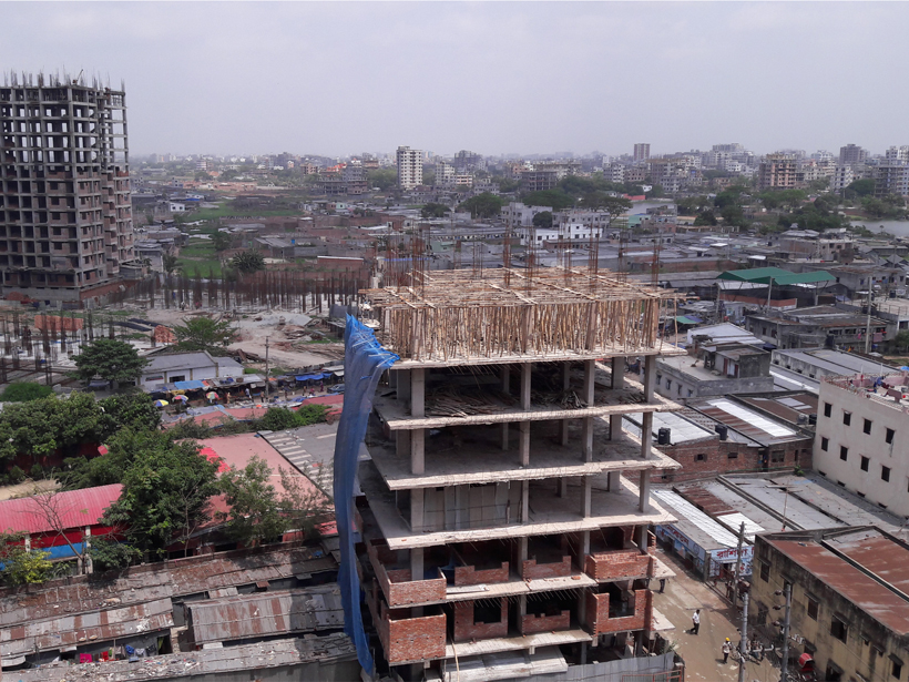
Along the Himalayan plate boundary, more than 50 million people now live in cities of at least a million inhabitants, including the capitals of Bangladesh, Bhutan, India, Nepal, and Pakistan. These rapidly growing, crowded megacities are filled with multistory concrete buildings that are likely vulnerable to earthquakes. Dhaka, Bangladesh’s capital, is one of the world’s fastest growing megacities. Some 16 million people currently live in Dhaka, and the potential collapse of services and accessibility after an earthquake compounds their risks.

Small Shifts, Big Effects
Urban vulnerabilities are only expressed when hazards trigger them. And in Bangladesh, hazards have the potential to be great.
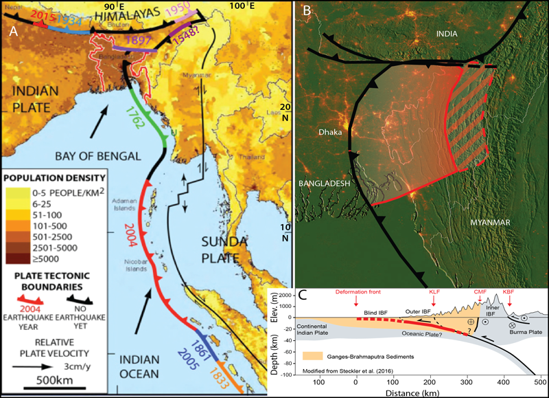
The Indian tectonic plate moves northward toward Eurasia at a pace of about 50 millimeters each year (Figure 1). This continuing collision has raised the great Himalayas and caused large destructive earthquakes along the plate boundary. Bangladesh is at the boundary’s northeastern end, which is complicated and poorly understood.
The plate boundary forms a roughly east–west arc along the Himalayas, bends 180° around the eastern Himalayan syntaxis, and then transitions into a broad zone of roughly north–south trending folds and thrusts, the Indo-Burma Ranges [Steckler et al., 2008]. The boundary continues southward to the Andaman-Sumatra subduction zone. Although the deformation zone that accommodates the motion between India and southeast Asia is often called the Burma platelet, multiple active structures indicate this “platelet” is not rigid.
Until recently, it was unclear whether the India–Indo-Burma motion included convergence [Gahalaut et al., 2013] and caused megathrust earthquakes. However, GPS data show that although the motion is highly oblique, it has a significant convergence component [Steckler et al., 2016]. This deformation, at 13–17 millimeters per year, appears to be loading the locked shallow megathrust, along which India subducts beneath Burma (Figures 1b and 1c). The strain from this deformation will likely be released in future large earthquakes, like those at other subduction zones [Steckler et al., 2016].
What We Know and What We Don’t
These new data provide only some of the information needed to estimate the danger of future earthquakes. Scientists also need better estimates of how often large earthquakes may happen on sufficiently close active faults, how big they may be, and how much shaking they may cause. Results are compiled in earthquake hazard maps predicting how much shaking is expected to occur with a certain probability within a certain period of time. These maps are used to prepare for earthquakes, notably via building codes that prescribe earthquake-resistant construction.
Although we have no way of knowing the future, we can make estimates with information about past earthquakes. For example, the Juan de Fuca plate subducts beneath northern California, Oregon, Washington, and British Columbia much as India subducts beneath the Indo-Burma Ranges. This area, known as the Cascadia subduction zone, was widely considered to be mostly aseismic until geological records became available. These records showed that large earthquakes happened some 530 years apart over the past 10,000 years, although the intervals are irregular [Goldfinger et al., 2012]. The most recent, in 1700 CE, is thought to have had a moment magnitude (Mw) of about 9.
We can gain insight on what to expect if we assume that the future will resemble the past when we derive earthquake hazard maps, but Earth does not always cooperate, and surprises are inevitable [Stein et al., 2012]. Add to this a lack of information, which makes Bangladesh’s situation much more challenging.
Hazard assessment for the Indo-Burma boundary is like the assessments for Cascadia before evidence of past megathrust earthquakes became available. Dhaka has been shaken by both teleseismic (distant) and local earthquakes during recent times [Akhter, 2010], but there is little documentation of past megathrust earthquakes. As a result, there is no good way to estimate how often such earthquakes may occur, how big they may be, or how much shaking they may cause.
The limited historical records we do have indicate that no megathrust earthquake has ruptured beneath Dhaka since 1610. If this is true, then the strain from more than 5 meters of motion has been stored on the megathrust. If this strain were released in one earthquake, it would have Mw ~8.2. If it has been longer since the last earthquake, the next temblor may be even bigger. Such a large earthquake seems possible: The plate boundary segment to the south ruptured in 1762 in an earthquake estimated as Mw 8.5–8.8 [Cummins, 2007; Wang et al., 2013].
Furthermore, the subduction zone here is extremely large and complex. Field geology and seismic data [Sikder and Alam, 2003; Betka et al., 2016] indicate that the megathrust is unusually broad and shallow, but it is uncertain whether and how often it ruptures seismically. It’s also unclear whether slip in an earthquake would taper to the west or whether the frontal zone would rupture in separate, less frequent earthquakes [Wang et al., 2014]. Might only some of the megathrust earthquakes propagate to the thrust tip near Dhaka? Splay faults rooting the folds and other faults within the plate boundary zone are also possible sources of damaging earthquakes [e.g., Debbarma et al., 2017]. The multiple scenarios increase the uncertainty in seismic hazard assessment.
Tackling the Problem
Although protecting millions of urban dwellers in Bangladesh might seem daunting, it is not hopeless; Bangladesh has tackled this kind of problem before.
Although protecting millions of urban dwellers in Bangladesh might seem daunting, it is not hopeless; Bangladesh has tackled this kind of problem before. Over a span of decades, Bangladesh has successfully reduced the risk from tropical cyclones. Shelters have been built along the coast, and a network of volunteers warns people when to evacuate. A cyclone in 1970, before the program, killed 300,000–500,000 people. By 2007, 1.5 million people took refuge in shelters ahead of Cyclone Sidr, reducing the death toll to about 4,300. Efforts continue to increase the stock of cyclone shelters and promote recovery after storms.
Similar efforts are beginning for earthquakes. The Ministry of Disaster Management and Relief has adopted 12 July as Earthquake Day, to be observed with earthquake drills and seminars to increase awareness. Scientists are preparing hazard maps for the country, although the maps are preliminary and are bound to have large uncertainties.
Initial studies and planning efforts are devoted to exploring the consequences of large earthquakes [World Bank and Earthquakes and Megacities Initiative, 2014]. Assessment of the building stock typical in developing nations shows their vulnerability to earthquakes. In Dhaka, ~21% of the buildings are easily damaged, unreinforced masonry (brick) construction. About 77% are reinforced concrete but have not been designed to resist earthquake shaking. Moreover, in many cases the site preparation and construction are thought to be poor. Although a building code was enacted in 2006, enforcement is limited, and newer buildings may be as vulnerable as older ones. For example, Dhaka’s Rana Plaza opened in 2009 when the code was in place. In 2013, it collapsed, killing more than 1,100 people.

A further problem is that Dhaka and most of Bangladesh are located on the sediments of the Ganges-Brahmaputra Delta. Earthquake shaking in thick sediments is generally enhanced relative to hard rock, but the amount depends on the size and shape of the basin and the sediment properties. Surface sediment is prone to liquefaction and sand boils, in which strong shaking causes saturated soil to lose strength or develop high pore pressure and sand eruptions. For example, the 2017 Mw 5.7 earthquake in Tripura, India [Debbarma et al., 2017], caused sand boils and damaged buildings in northeast Bangladesh about 40 kilometers away.
Reasonable Risk Reduction Steps
Mitigation is like buying insurance; we spend money today to reduce consequences of possible future events.
The case study of Bangladesh illustrates the challenge of how to address an uncertain hazard, given limited resources [Stein and Stein, 2014]. How much mitigation is enough? Mitigation is like buying insurance; we spend money today to reduce consequences of possible future events. More mitigation reduces future losses but costs more now; resources used for mitigation are not available for other purposes. Money spent making existing schools earthquake resistant cannot be used to build schools or hire teachers for communities that have none [Kenny, 2009].
Ideally, if the hazard were well understood, economic models could be used to develop mitigation strategies. The total cost of natural disasters to society is the sum of the expected loss in future disasters and the cost of mitigation. This total depends on the amount of mitigation, shown schematically by the U-shaped curve in Figure 2.
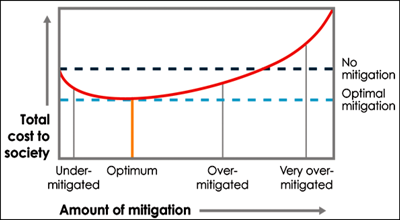
If we undertake no mitigation, we have no mitigation costs (left side of the curve) but expect high losses, so it makes sense to invest more in mitigation. Increased mitigation should decrease losses, so the curve goes down. Eventually, however, the cost of more mitigation exceeds the reduced losses, and the curve rises again. These additional resources would be better invested otherwise. The optimum mitigation is the sweet spot at the bottom of the curve.
Uncertainties in our ability to assess hazards and resulting losses limit our ability to determine an optimal strategy. Moreover, given limited resources, a community is likely to spend less than the optimum anyway. Fortunately, spending less is better than doing nothing (Figure 2), and we can still suggest strategies that make sense given the high uncertainty and limited resources. This approach follows the idea that “the best is the enemy of the good”: Requiring too much safety would cost so much that nothing is likely to be done.
Public education and understanding is needed to raise support for any level of investment. Recent nearby earthquakes, like the 2004 Sumatra, 2015 Gorkha, and 2016 Manipur earthquakes, which caused shaking and damage in Bangladesh, have raised earthquake awareness in the country. The scientific community is providing better understanding and monitoring of tectonics and earthquake processes in and around Bangladesh. These developments offer Bangladesh the opportunity to increase earthquake preparedness and reduce earthquake risk [Akhter, 2010].
Building New Versus Fixing Old
As the population shifts from rural to urban, the extensive construction that follows provides an opportunity for earthquake risk reduction. This opportunity stems from one key idea: A crucial step to mitigating earthquake risk in Bangladesh is enforcing the building code.
Studies show that a moderate degree of safety is achievable with a modest, perhaps 5%–10%, increase in building costs [Schulze et al., 1987]. Over time, natural turnover of buildings will make communities more resilient. Thus, an approach to reducing risk is to plan the desired fraction of safer buildings over time and to incentivize new safer construction over modifying unsafe existing buildings.
Because strengthening (retrofitting) an older building can cost between 25% and 70% of the building’s value, we recommend this approach for only the most critical structures.
Because strengthening (retrofitting) an older building can cost between 25% and 70% of the building’s value, we recommend this approach for only the most critical structures [Arikan et al., 2005; McMonies, 2016]. For example, the Bangladeshi government has decided to retrofit some fire stations.
Outside of critical infrastructure, the ideal case is when tenants would pay more for ensuring the safety of their buildings. However, conditions aren’t always ideal.
Erdik and Durukal [2008] report on similar issues faced in Istanbul, a comparable setting. Assessments showed that retrofits would cost about 40% of replacement value. Their study showed that Istanbul residents viewed this “as an investment with no financial return and, as such, no conceivable reduction in insurance premium, property tax, or building permit fees would be sufficient to create an incentive for retrofitting.” This response was rational, unless one postulates a high probability of major damage on a short timescale [Kenny, 2009]. Hence, a major retrofitting program would require large investment of public funds, which is unrealistic given other needs.
Putting It All Together
Recommendations by World Bank and Earthquakes and Megacities Initiative [2014] favor raising public earthquake awareness; building competency for architects, engineers, planners, and construction professionals; improving emergency response; and planning land use in a risk-sensitive manner. Ongoing programs, such as the annual U.S.-Bangladesh Pacific Resilience Disaster Response Exercise and Exchange, the Global Facility for Disaster Reduction and Recovery program, and the Comprehensive Disaster Management Program, build toward these goals.
Robust risk management is practical, even for developing nations. It involves recognizing uncertainties and developing policies that should give a reasonable outcome for a range of the possible hazard and loss scenarios. It requires accepting the need for humility in the face of the complexities and capriciousness of nature while making realistic policies that the public accepts. Although long-term investments in risk reduction compete with immediate needs, they will pay back handsomely should a major earthquake strike.
Acknowledgments
We thank the editors and reviewers for helping to improve this paper. This work was supported by NSF grant OISE 09-68354. LDEO contribution number 8192.
References
Akhter, S. H. (2010), Earthquakes of Dhaka, in Environment of Capital Dhaka, Dhaka Celebration Ser., vol. 6, edited by M. A. Islam, pp. 401–426, Asiatic Soc. of Bangladesh, Dhaka.
Arikan, M., H. Sucuoglu, and G. Macit (2005), Economic assessment of the seismic retrofitting of low-cost apartment buildings, J. Earthquake Eng., 9, 577–584, https://doi.org/10.1080/13632460509350556.
Betka, P. M., et al. (2016), The Indo-Burma Ranges: Eocene-Pliocene coevolution of the paleo-Brahmaputra fluvial-deltaic system and Indo-Burma accretionary prism, Abstract T22A-06 presented at 2016 Fall Meeting, AGU, San Francisco, Calif.
Cummins, P. R. (2007), The potential for giant tsunamigenic earthquakes in the northern Bay of Bengal, Nature, 449, 75–78, https://doi.org/10.1038/nature06088.
Debbarma, J., et al. (2017), Preliminary observations from the 3 January 2017, Mw 5.6 Manu, Tripura (India) earthquake, J. Asian Earth Sci., 148, 173–180, https://doi.org/10.1016/j.jseaes.2017.08.030.
Erdik, M., and E. Durukal (2008), Earthquake risk and its mitigation in Istanbul, Nat. Hazards, 44(2), 181–197, https://doi.org/10.1007/s11069-007-9110-9.
Gahalaut, V. K., et al. (2013), Aseismic plate boundary in the Indo-Burmese wedge, northwest Sunda Arc, Geology, 41, 235–238, https://doi.org/10.1130/G33771.1.
Goldfinger, C. C., et al. (2012), Turbidite event history—Methods and implications for Holocene paleoseismicity of the Cascadia subduction zone, U.S. Geol. Surv. Prof. Pap., 1661-F, 170 pp., https://pubs.usgs.gov/pp/pp1661f/.
Kenny, C. (2009), Why do people die in earthquakes? The costs, benefits and institutions of disaster risk reduction in developing countries, World Bank Policy Res. Work. Pap. WPS 4823, World Bank, Washington, D. C., https://doi.org/10.1596/1813-9450-4823.
McMonies, W. (2016), Portland’s unreinforced masonry seismic retrofit project, Cent. Real Estate Q. Rep., 10(2), 5–13.
Rittel, H. W., and M. M. Webber (1973), Dilemmas in a general theory of planning, Policy Sci., 4(2), 155–169, https://doi.org/10.1007/BF01405730.
Schulze, W. D., et al. (1987), Benefits and costs of earthquake resistant buildings, South. Econ. J., 53(4), 934–951, https://doi.org/10.2307/1059687.
Sikder, A. M., and M. M. Alam (2003), 2-D modelling of the anticlinal structures and structural development of the eastern fold belt of the Bengal basin, Bangladesh, Sediment. Geol., 155, 209–226, https://doi.org/10.1016/S0037-0738(02)00181-1.
Stang, G., and B. Ujvari (2015), Climate change as a ‘wicked problem,’ Alert 52, EU Inst. for Secur. Stud., Paris, https://doi.org/10.2815/705163.
Steckler, M. S., S. H. Akhter, and L. Seeber (2008), Collision of the Ganges–Brahmaputra Delta with the Burma Arc: Implications for earthquake hazard, Earth Planet. Sci. Lett., 273(3), 367–378, https://doi.org/10.1016/j.epsl.2008.07.009.
Steckler, M. S., et al. (2016), Locked and loading megathrust linked to active subduction beneath the Indo-Burman Ranges, Nat. Geosci., 9(8), 615–618, https://doi.org/10.1038/ngeo2760.
Stein, S., and J. L. Stein (2014), Playing Against Nature: Integrating Science and Economics to Mitigate Natural Hazards in an Uncertain World, AGU, Washington, D. C., https://doi.org/10.1002/9781118620786.
Stein, S., R. J. Geller, and M. Liu (2012), Why earthquake hazard maps often fail and what to do about it, Tectonophysics, 562, 1–25, https://doi.org/10.1016/j.tecto.2012.06.047.
Wang, Y., et al. (2013), Permanent upper plate deformation in western Myanmar during the great 1762 earthquake: Implications for neotectonic behavior of the northern Sunda megathrust, J. Geophys. Res. Solid Earth, 118, 1,277–1,303, https://doi.org/10.1002/jgrb.50121.
Wang, Y., et al. (2014), Active tectonics and earthquake potential of the Myanmar region, J. Geophys. Res. Solid Earth, 119, 3,767–3,822, https://doi.org/10.1002/2013JB010762.
World Bank and Earthquakes and Megacities Initiative (2014), Dhaka profile and earthquake risk atlas, Bangladesh Urban Earthquake Resilience Project, 82 pp., Disaster Risk Manage. and Clim. Change Unit, South Asia Sustainable Dev. Dep., World Bank Office Dhaka, Dhaka
Author Information
Michael S. Steckler (email: [email protected]), Lamont-Doherty Earth Observatory, Columbia University, Palisades, N.Y.; Seth Stein, Department of Earth and Planetary Sciences and Institute for Policy Research, Northwestern University, Evanston, Ill.; S. Humayun Akhter, Department of Geology, University of Dhaka, Bangladesh; and Leonardo Seeber, Lamont-Doherty Earth Observatory, Columbia University, Palisades, N.Y.
Citation:
Steckler, M. S.,Stein, S.,Akhter, S. H., and Seeber, L. (2018), The wicked problem of earthquake hazard in developing countries, Eos, 99, https://doi.org/10.1029/2018EO093625. Published on 07 March 2018.
Text © 2018. The authors. CC BY 3.0
Except where otherwise noted, images are subject to copyright. Any reuse without express permission from the copyright owner is prohibited.