The Grand Canyon is not the longest, widest, or deepest canyon on Earth, but as the only canyon among the seven natural wonders of the world, it’s arguably the planet’s grandest canyon. So what makes it so grand? And how long do geologists expect it to retain that honor?
As it flows across northwest Arizona, the Colorado River and its dozens of tributaries have carved a wondrously intricate rainbow of interconnected canyons. From overlooks on the North and South Rims of Grand Canyon National Park, the views are unfathomable.
To have any hope of grasping the enormity of the landscape and how it was carved by water, however, you have to descend below the rims.
The Grand Canyon is one of my favorite backpacking destinations. Trails from the rim to the river lose 1,500 meters of elevation, taking you back in time from the 230-million-year-old Kaibab Limestone on the rim to the 1.7-billion-year-old Precambrian basement rocks along the river. The geologic layer cake is so rich that as you descend, every downward step moves you tens of thousands of years backward in geologic time. (Of course, then you have to hike back up through all that history too.)

For much of the hike, the river is elusive, often hidden in folds of the landscape. When it does appear, it’s a thin ribbon, seemingly too inconsequential to be held responsible for so much erosion. But don’t underestimate it. Even dammed upstream and downstream, the Colorado is a formidable river.
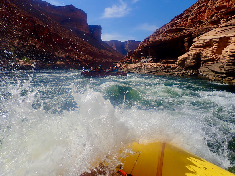
To truly understand the power of the Colorado River, you have to touch it, swallow it, raft it.
To truly understand the power of the Colorado, you have to touch it, swallow it, raftit. Scoring a permit for a private river trip is akin to winning the lottery—less than 1% of applicants are awarded permits for the prime weather months. The more common option is to sign up for a guided commercial trip, which can run anywhere from $3,000 to $6,000, depending on the trip type, length, and amenities. And if you ever get a phone call from a fairy godmother offering you a last-minute spot on a private rafting trip through the Grand Canyon, say yes! (Thank you, Zoe!)
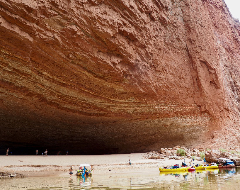
Only once you’ve floated a few hundred kilometers of the inner gorge, past enormous caverns scooped out by flooding and glittering crystalline rocks polished mirror smooth by eons of white water, will you truly appreciate the relentless power of the still mighty Colorado.
How Old Is the Grand Canyon?

The Grand Canyon is one of the planet’s most dramatic geologic showpieces, but despite its fame, it still has mysteries. Canyons are erosive environments, where telltale evidence of their origin stories is often swept downstream and out to sea, making it difficult to determine their exact age.
Currently, the most widely accepted theory places the Grand Canyon at 5–6 million years old. But a few wildcard studies have suggested that some sections of the canyon may have been carved out to near-modern depths as early as 70 million years ago by a Cretaceous era river that flowed through the region from west to east, the opposite direction of the modern Colorado.
But “if a paleocanyon was carved by a different river system flowing from a different headwaters in a different direction through only part of the main canyon,” asked Ryan Crow, a geomorphologist at the U.S. Geological Survey (USGS) in Flagstaff, Ariz., “is it fair to call that ‘the Grand Canyon’?”
“My preference is to define the Colorado River as a river that drains the Rocky Mountains in about the same shape and orientation as we see today,” Crow said, a definition that helps constrain the birth of the Grand Canyon to around 5 to 6 million years ago, when a major river began blazing a course from the Colorado Rockies across the Southwest to the Pacific Ocean.
Geologic Time Includes Now
Most Grand Canyon rafting trips start at Lees Ferry, 25 kilometers downstream from the Glen Canyon Dam, a 216-meter-high concrete edifice that controls the flow of the Colorado River, creating a massive water reservoir behind the dam known as Lake Powell.

Before the dam was completed in 1966, seasonal floods roared through the Grand Canyon at flows as high as 5,700 cubic meters per second. The once famously muddy river, derided as “too thick to drink, too thin to plow,” is estimated to have transported 140 million tons of sediment eroded from all over the Southwest each year.
These days, the carefully controlled Colorado fluctuates between 225 and 700 cubic meters per second, and the dam traps nearly all the upstream sediment, keeping the Colorado River unnaturally clear for most of the year.

The Colorado’s blue-green water may look beautiful, but it strips away sandbars and sandy beaches, along with prehistoric riverside ruins and artifacts that have been buried and preserved by sand for thousands of years. The clear water also exposes aquatic life that evolved to live in opaque water, like the endangered humpback chub, to more ultraviolet light and warmer water temperatures. And the lack of seasonal floods allows dense tangles of invasive tamarisk to flourish along the banks.
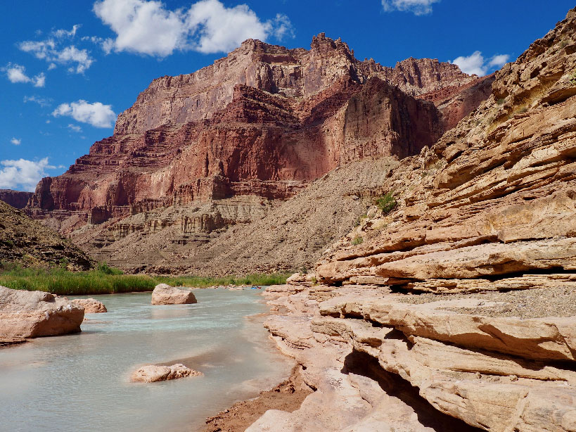
Every now and then, one of the side canyons that empty into the Colorado will flood, carrying enough sediment to temporarily turn the Colorado brown. On day 15 of my 20-day rafting trip, while we were camped at Parashant Canyon, the river went from green to milky brown within the space of an hour and stayed that way for the rest of our trip.

“You were lucky to see that. The canyon hasn’t had many flooding events this year,” said David Topping, a hydrologist with the USGS in Flagstaff who studies sediment transport in the Colorado River. Checking the records from the stream gauges that monitor the Grand Canyon’s many side canyons, Topping told me that the dramatic color change was due to flooding on the Little Colorado River 2 days prior and 220 kilometers upstream.
In an effort to move more sediment through the canyon and restore dwindling sandbars, the USGS and the Bureau of Reclamation conducted high-flow experiments (HFEs) sporadically between 1996 and 2018. HFEs flush water at rates of up to 1,270 meters per second through the Glen Canyon Dam, twice the usual flow rate but still less than one quarter of predam flooding events.
Because the dam is not designed to pass sediment, sand is supplied by side canyons like the Paria River Canyon, which meets the Colorado 27 kilometers downstream from the dam, just past Lees Ferry. This year was a dry year, and the Paria River did not see enough storm events to pile up enough sand at its mouth to trigger an HFE, which are usually scheduled for a 3- to 5-day period in November.
For adventurous river runners, HFEs can be a thrilling opportunity to experience the Colorado River in a more natural state. “When we are gearing up for a high-flow experiment, there’s quite a bit of press about it, and the river runners are notified ahead of time,” Topping said.
At a rate of 1,000 cubic meters per second, it takes about 96 hours for floodwaters to flush through the canyon. “Some people like boating on high water,” Topping said, but “typically, people pull over and watch the flood go by and then they get to enjoy camping on really big sandbars for the rest of their trip.”
As for all the sediment trapped in Lake Powell, a 1986 U.S. Bureau of Reclamation survey found that it will take about 700 years for the lake to fill with sediment, rendering the dam useless for hydropower and water catchment. Will the dam last that long? Will people still be living in the Southwest? Only time will tell.
Will the Grand Canyon Keep Getting Grander?
The Colorado River is bracketed upstream by the Glen Canyon Dam and downstream by the Hoover Dam, but the massive man-made structures will prove no match for the ravages of geologic time.
For now, the Colorado River is bracketed upstream by the Glen Canyon Dam and downstream by the Hoover Dam, but the massive man-made structures will prove no match for the ravages of geologic time. After all, in the not so distant past, the Colorado River repeatedly eroded much larger obstacles.
Between 100,000 and 800,000 years ago, lava from a series of volcanic eruptions tied to the still-active San Francisco Volcanic Field in northern Arizona flowed into the Grand Canyon in the vicinity of Vulcan’s Throne and Lava Falls Rapid, in some cases completely damming the Colorado River with lava. “In the rock record, we can see evidence of lava flowing down a dry riverbed behind a lava dam,” Crow said.
The largest of these lava dams was 400 meters high, twice the height of the Glen Canyon Dam. But within a few hundred years, the river filled the canyon behind the dam and then overtopped it, continuing its journey downstream and eventually eroding away the dam altogether.

“We think that even the biggest dams were probably removed within a few hundred years after each eruption,” Crow said. “As many as 10 lava dams may have formed, but the river blew them all out pretty quickly and resumed downcutting the canyon again as if the dams had never been there.”
So although Glen Canyon Dam may currently be crimping the Colorado’s erosive power, as with everything on geologic timescales, it’s only temporary.
“In some ways, the lava dams can be seen as an analogue for the concrete dams,” Crow said. Future river runners take heed: Someday, the mighty Colorado will overcome its concrete dams and run wild once again, deepening and widening its course, exposing more rock layers, and ensuring that the Grand Canyon retains its status as the planet’s grandest canyon for eons to come.
—Mary Caperton Morton (@theblondecoyote), Science Writer
Citation:
Morton, M. C. (2019), Will Earth’s grandest canyon keep getting grander?, Eos, 100, https://doi.org/10.1029/2019EO136537. Published on 19 November 2019.
Text © 2019. The authors. CC BY-NC-ND 3.0
Except where otherwise noted, images are subject to copyright. Any reuse without express permission from the copyright owner is prohibited.