Fortune is an arbiter of half of our actions. … I liken her to one of these violent rivers which, when they become enraged, flood the plains, ruin the trees and the buildings. … It is not as if men, when times are quiet, could not provide for them with dikes and dams so that when they rise later … their impetus is neither so wanton nor so damaging.
—The Prince [Machiavelli, 1532; translation, 1985]
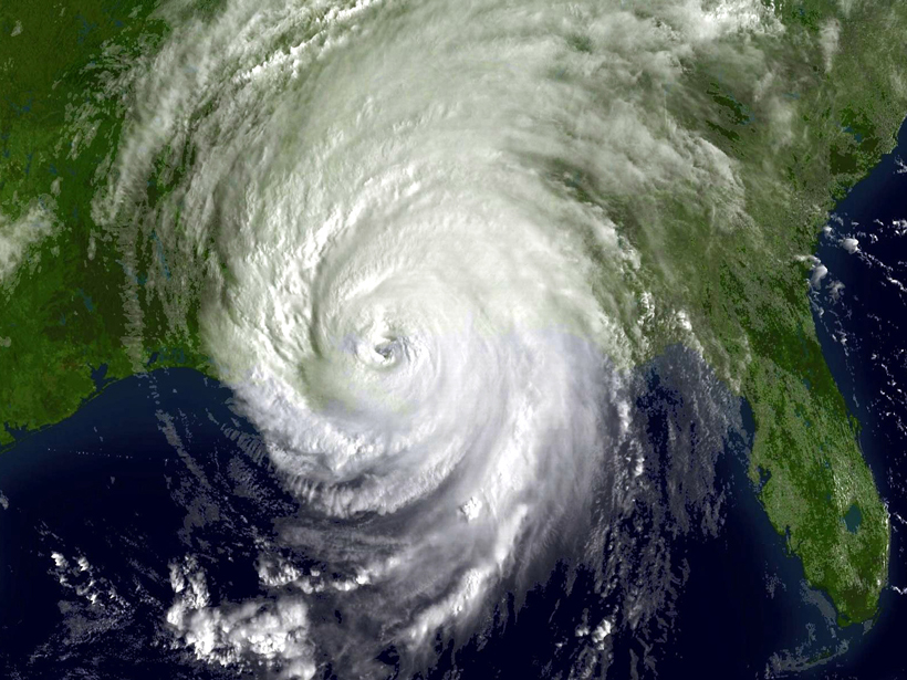
On 29 August 2005, Hurricane Katrina struck coastal Mississippi, Alabama, and Louisiana. Damage was widespread, but the city of New Orleans was hit especially hard.
On this tenth anniversary of the disaster, it’s worth looking back on how scientists and the nation responded to Katrina. Looking forward—given continuing coastal development, accelerating sea level rise, and warming oceans that can intensify storm surge—how can we prepare for future threats and disasters?
One mitigation strategy—relocating people and sensitive infrastructure to higher ground—has not been explored fully and eventually will need to be considered here and in other coastal areas as sea level rise accelerates.
A Brief History of the Storm and Its Aftermath
2005 had an active hurricane season, with 28 named storms and four category 5 hurricanes. After crossing Florida, Katrina intensified to category 5 as it passed over the warm waters of the Gulf of Mexico [Trenberth et al., 2007] but probably declined to category 3 by the time it struck the city.
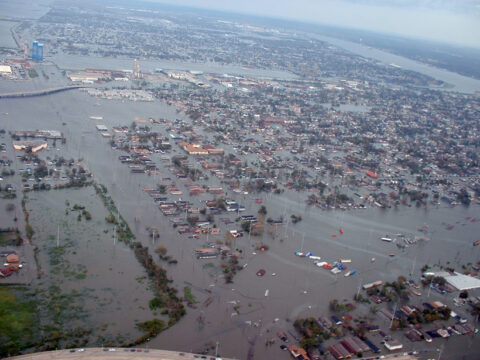
Although warned in advance, some residents were unable or unwilling to evacuate. Of the approximately 1800 fatalities associated with Katrina, about a thousand were New Orleans residents who remained behind. Responders attributed many deaths to drowning; rising water trapped many people in the attics of single-story homes.
During the storm, Katrina breached many of the city’s levees, which previously had protected the city from flooding by the Mississippi River and Lake Pontchartrain. For many days after the disaster, television news showed heartbreaking pictures of people in squalid conditions, awaiting relief and evacuation that seemed painfully slow. Analysts and community leaders widely criticized federal, state, and local governments for inadequate preparation and inept relief efforts.
Katrina stands as the costliest disaster in U.S. history, with losses exceeding $100 billion, and the third deadliest hurricane, after the 1900 Galveston hurricane that killed more than 6000 people and the 1928 Okeechobee hurricane that killed between 1800 and 2500 people. Many observers were surprised that a disaster like Katrina could befall a wealthy, technologically advanced nation like the United States. Ten years later, the population of New Orleans remains below prestorm levels, and some areas remain damaged.
Flood Mitigation and Geology
Experts pointed out the dangers of flooding from hurricane storm surge in New Orleans many years before Katrina struck. Similar events in 1965 and 1969 from Hurricanes Betsy and Camille flooded parts of the city.
Experts pointed out the dangers of flooding from hurricane storm surge in New Orleans many years before Katrina struck.
New Orleans’s unique geography makes it especially susceptible to flooding. Although all coastal cities are experiencing rising sea levels, New Orleans faces the additional problem of subsidence.
The city is constructed on the Mississippi Delta, and deltas subside from processes that include sediment compaction and crustal loading. In a natural deltaic system, sediment deposition occurs during spring floods and, over time, maintains the delta surface at or near sea level, compensating for subsidence. Along the lower Mississippi, levees prevent this natural renewal, and the channelized bed forces sediment deposition farther out in the Gulf of Mexico. Dams on the upper Mississippi also reduce sediment supply.
Settlers built the original town of New Orleans (the popular French Quarter familiar to tourists) on relatively high elevation natural levees adjacent to the river. However, the city grew far beyond this favorable site in the pre-Katrina years, occupying lower-elevation areas.
The highest rates of subsidence can be found in recently reclaimed land along the shore of Lake Pontchartrain, where sediments tend to compact at high rates for several decades after reclamation [e.g., Kim et al., 2010], or in former marshes drained for urbanization, exposing organic matter to oxidation. At the time of Katrina, New Orleans was subsiding by about 5–6 millimeters per year, with some areas sinking faster than 20 millimeters per year [Dixon et al., 2006].
This latter process likely explains some of the lowest-lying areas of New Orleans, which were drained for urbanization in the mid- to late 1800s. Some of these areas currently lie 3 meters or more below sea level.
Costs
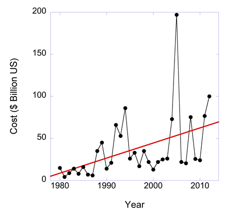
Disasters in the United States have been mainly associated with weather- and climate-related events such as floods, droughts, and wildfires. What’s more, the costs of such disasters are increasing (Figure 1).
Some of the cost increase simply reflects increased population. However, since 1980, costs have increased fivefold during a period when population increased by only about 35%.
Some of the cost increase therefore likely reflects increasing frequency and intensity of weather-related events, although a detailed analysis would have to account for the increased value of coastal real estate.
What Have We Learned?
Katrina represented a major disaster for the United States but also provides an opportunity for the nation and the world to learn from past mistakes. Scientists and engineers have conducted forensic analysis [American Society of Civil Engineers (ASCE), 2007; Interagency Performance Evaluation Task Force (IPET), 2007–2009] of some infrastructure failures, but to my knowledge, a far-reaching analysis of the various political, engineering, and scientific missteps that led to the disaster and its aftermath has never been done.

Katrina won’t be our last major disaster. But using Katrina as a lens, we can take a hard look at all aspects of our preparations for and responses to disasters to ensure better future outcomes. Although some aspects of the Katrina disaster are unique (e.g., the low elevation of parts of New Orleans), the event shares common factors with a wide range of natural and human-made disasters.
Levee Failures
The Army Corps of Engineers and the American Society of Civil Engineers [ASCE, 2007; IPET, 2007–2009] reviewed the levee failures. One conclusion: Low elevation contributed to several levee failures when storm surge overtopped and then eroded earthen structures.
The levee adjacent to the Mississippi River–Gulf Outlet Canal failed in this way, contributing to flooding of St. Bernard Parish, where 80% of housing was destroyed or damaged. Measurements by satellite geodesy between 2002 and 2005 showed this levee subsiding at rates sufficient to lower its elevation by about 1 meter since its construction in the 1960s [Dixon et al., 2006].
An important note: Engineers conducted previous geodetic measurements on the levees with terrestrial leveling, requiring the use of a local reference point, which may also have been subsiding [ASCE, 2007].
Pumping Stations and Backup Power
Low-elevation pumping stations, control facilities, and backup power at critical facilities in New Orleans failed during flooding [e.g., ASCE, 2007; Fink, 2013]. A similar design flaw doomed the Fukushima nuclear facility in Japan 6 years later when backup power was disrupted by tsunami-induced flooding, leading to overheating and large-scale radiation release [Nöggerath et al., 2011].
How to Rebuild After Disasters?
One opportunity missed during the rebuilding phase was the chance to move sensitive infrastructure and housing to higher ground (a significant fraction of the city is located at or above sea level). Sea level rise is accelerating in the Gulf region [e.g., Karegar et al., 2015], and subsidence continues, so Katrina is unlikely to be the last flood experienced by the city.
Many people believe that widespread relocation is unrealistic. People would refuse to move, and in any case, it would be too expensive to subsidize the transition, they argue.
A generous government subsidy, combined with a clear scientific statement about long-term flood risk, could help persuade people to shift to higher ground.
I can’t speak to refusals to move, but a generous government subsidy, combined with a clear scientific statement about long-term flood risk, could be useful to help persuade people to shift to higher ground. To my knowledge, no such statement was ever made following Katrina.
Regarding the actual cost of relocation, less than 20% of the population lives at dangerously low elevation. My back-of-the-envelope calculations suggest that people could be moved to nearby higher ground for far less than the United States spent on bailing out bankrupt firms in the 2008 financial crisis.
Seven years after Katrina, 2012’s Hurricane Sandy, with many features in common with Katrina—including prior expert warnings and the role of low elevation and warm ocean water—showed us how little progress we’ve made regarding storm mitigation.
Recommendations
Warming seas and rising seas increase the likelihood of future storm surge–induced flooding (see Figure 2). As scientists, we struggle to communicate to the public and policy makers how apparently small long-term average changes in temperature and sea level, convolved with natural short-term variability and increased coastal population density, lead to big increases in the risk of coastal flooding.
![Fig. 2. Average sea surface temperature (SST) in the North Atlantic since 1980, relative to 1901–1970, for the ocean area bounded by 0°– 50°N and 10°W– 80°W. Computed from the Hadley Centre Global Sea Ice and Sea Surface Temperature dataset [Rayner et al., 2003]. Credit: Q. Yang](https://eos.org/wp-content/uploads/2015/08/Fig-2_embed4_Web-480x392.jpg)
The local subsidence that played a role in Katrina’s flooding makes it a useful indicator—a teachable moment—and a harbinger of disasters that will come eventually over a much broader area of the coastal United States. Houston, Tampa Bay, Miami, and cities around the Chesapeake Bay, such as Norfolk and Baltimore, are especially at risk.
Somehow, scientists need to make it clear that one degree of average temperature increase and a few millimeters per year of annual sea level rise mean many more Katrinas, each with the potential to cause thousands of fatalities, tens of billions of dollars in damages, and the destruction of major cities.
Everyone has his or her own list of lessons learned from Katrina. Here is a subset of my list, focusing on issues that apply beyond New Orleans:
- Scientists need to do a better job of communicating the long-term risks associated with rising sea level, increasing atmospheric and ocean temperatures, and intensifying storm surge. Devastation following Sandy highlighted that Katrina was not an anomaly—the prior storm just happened to be the first to get our attention.
- Geodesy has a role to play in highlighting coastal areas undergoing rapid subsidence. These areas serve as important canaries in the coal mine for the public and policy makers, illustrating in the short term (over the next few decades) what long-term (over the next few centuries) sea level rise will actually look like.
- Safety features such as backup power and communication and control facilities need to be designed and sited to be safe from flooding, high winds, and other damaging conditions.
- We need to develop recovery mechanisms for natural disasters that do not necessarily involve rebuilding in exactly the same spot. In the case of sea level rise and low-lying coastal areas, this means zoning and other policies that limit new construction in sensitive areas and promote a managed retreat from the coast, allowing some places to revert to green space and wetland.
Because the economic lifetime of many buildings is on the order of 50 years, relocation to higher ground should be possible without huge economic disruption and could be encouraged with tax incentives and relocation subsidies after a disaster. The 50-year time scale is longer than normally used in government and business planning but may be required if we are to avoid the worst effects of sea level rise.
Future Disasters and Our New Reality
Let’s resolve to do better in the ways that we prepare for and respond to inevitable disasters.
It’s true that the next disaster will occur at some unpredictable time in the future, but the devastation from Katrina and Sandy is a reminder that this future is not necessarily far away.
On this tenth anniversary of Hurricane Katrina and its devastation of New Orleans, let’s resolve to do better, as scientists and as communities, in the ways that we communicate and listen about future threats and in the ways that we prepare for and respond to these inevitable disasters.
Acknowledgments
I thank Seth Stein and Kevin Trenberth for reviews. The National Science Foundation, NASA, and the Department of Energy provided funding for some of the research described here.
References
American Society of Civil Engineers (ASCE) (2007), The New Orleans Hurricane Protection System: What Went Wrong and Why. A Report by the American Society of Civil Engineers Hurricane Katrina External Review Panel, Reston, Va.
Dixon, T. H., F. Amelung, A. Ferretti, F. Novali, F. Rocca, R. Dokka, G. Sella, S.-W. Kim, S. Wdowinski, and D. Whitman (2006), New Orleans subsidence: Rates and spatial variation measured by permanent scatterer interferometry, Nature, 441, 587–588.
Fink, S. (2013), Five Days at Memorial: Life and Death in a Storm-Ravaged Hospital, Crown, New York.
Interagency Performance Evaluation Task Force (IPET) (2007–2009), Performance evaluation of the New Orleans and Southeast Louisiana Hurricane Protection System: Final report of the Interagency Performance Evaluation Task Force, 9 vols., U.S. Army Corps of Eng., Vicksburg, Miss.
Karegar, M. A., T. H. Dixon, and R. Malservisi (2015), A three-dimensional surface velocity field for the Mississippi Delta: Implications for coastal restoration and flood potential, Geology, 43, 519–522.
Kim, S. W., S. Wdowinski, T. H. Dixon, F. Amelung, J. W. Kim, and J.-S. Won (2010), Measurements and predictions of subsidence induced by soil consolidation using persistent scatterer InSAR and a hyperbolic model, Geophys. Res. Lett., 37, L05304, doi:10.1029/2009GL041644.
Machiavelli, N. ([1532] 1985) The Prince, translated by H. C. Mansfield, Jr., Univ. of Chicago Press, Chicago, Ill.
Nöggerath, J., R. J. Geller, and V. K. Gusiakov (2011), Fukushima: The myth of safety, the reality of geoscience, Bull. At. Sci., 67, 37–46.
Rayner, N. A., D. E. Parker, E. B. Horton, C. K. Folland, L. V. Alexander, D. P. Rowell, E. C. Kent, and A. Kaplan (2003), Global analyses of sea surface temperature, sea ice, and night marine air temperature since the late nineteenth century, J. Geophys. Res., 108(D14), 4407, doi:10.1029/2002jd002670.
Trenberth, K. E., C. A. Davis, and J. Fasullo (2007), Water and energy budgets of hurricanes: Case studies of Ivan and Katrina, J. Geophys. Res., 112, D23106, doi:10.1029/2006JD008303.
—Timothy H. Dixon, School of Geosciences, University of South Florida, Tampa; email: [email protected]
Citation: Dixon, T. H. (2015), Ten years after Katrina: What have we learned?, Eos, 96, doi:10.1029/2015EO034703. Published on 27 August 2015.
Text © 2015. The authors. CC BY-NC 3.0
Except where otherwise noted, images are subject to copyright. Any reuse without express permission from the copyright owner is prohibited.