One of the hottest technology trends of the past few years has been the emergence of the small remotely piloted aircraft commonly known as drones. Buzzing quadcopters have taken the Internet by storm with breathtaking aerial videos of their attempts to deliver packages, beer, and even marriage proposals—but they also have immense potential for Earth science by offering scientists an airborne platform to monitor the environment.
However, drones come at a cost, and they are often difficult for research teams to maintain. Operating them requires competent (and licensed) pilots, navigating relevant regulations (which are still in flux), and the money to purchase both the airframes and the equipment they will carry—all in addition, of course, to the scientific expertise of the researchers themselves.
To help scientists address these challenges, the Center for Transformative Environmental Monitoring Programs (CTEMPs), a community user facility for environmental sensing supported by the National Science Foundation (NSF), is expanding its instrumentation this year to include drones—also known as unmanned aircraft systems (UASs). It will take on the operational burden and allow researchers to deploy UASs to their Earth study sites, freeing users to focus on their science.
UASs represent a significant advance in remote sensing, with the capability to rapidly deploy and to image terrain at very high resolutions in the visible and infrared spectrum. In particular, they have tremendous potential for environmental monitoring, as they can capture data at scales that are more detailed than traditional aircraft and broader than point sensors. This neatly fills a gap in current instrument capabilities.
Building a Scientific Drone Fleet
Since 2009, the NSF has funded CTEMPs to operate environmental sensing equipment to serve the scientific community, with centers at Oregon State University, University of Nevada, Reno, and Smith College. CTEMPs traditionally deploys fiber optic–based temperature monitoring systems to researchers’ field sites across the United States and internationally.
As drones become more widely available, CTEMPs is seeking to expand its instrument suite to include drones capable of covering areas large enough for hydrologic and ecological field studies and observatories—roughly from 1 to 100 square kilometers. In December 2014, NSF awarded funds to CTEMPs, in the new “AirCTEMPs” service package, to add drone operations.
The CTEMPs campuses already have more than a dozen airframes, outfitted with laser terrain scanners (lidar), visible-light cameras, and infrared and thermal sensors. AirCTEMPs staff have obtained dozens of certificates from the U.S. Federal Aviation Administration (FAA) that authorize drone flights in states including Oregon, Nevada, Montana, and Oklahoma.
Drones on Demand
Drones can be a potentially transformative scientific tool, but operating them comes with numerous challenges.
Drones can be a potentially transformative scientific tool, but operating them comes with numerous challenges.
First, UAS equipment is expensive. The current CTEMPs lidar costs almost $30,000, the monorotor helicopter that carries the lidar is more than $20,000, and the software to digest these data is another $10,000.
Second, drones require teams to staff up—for example, currently, most FAA-approved UAS flights in the United States require that two pilots be present. This creates staffing challenges for most university researchers.
Finally, the FAA application process for a Certificate of Authorization to operate a UAS is highly technical and time-consuming. Programming flight paths, organizing the data, and interpreting results requires specialized technical skills that most Earth scientists do not have or need to use on a regular basis.
CTEMPs aims to acquire and operate expensive and sophisticated equipment that would normally be prohibitive for single investigators and make it widely accessible to the community. CTEMPs also focuses on instrumentation that is unlikely to be used continuously by any single investigator. By providing instrumentation when it is needed, the instruments can serve a much larger community.
A Proven Operating Model
CTEMPs launched 5 years ago, applying this operational model to a then new technology—distributed temperature sensing (DTS), which uses fiber-optic cables to record environmental temperatures. Whereas a traditional thermometer takes a measurement at a single point, DTS works by measuring how changes in temperature affect the fiber’s optical properties along its entire length. In this way, scientists can obtain tens of thousands of simultaneous measurements to accuracies of nearly 0.01°C.
Although the technology might have great potential, its successful adoption often depends more on the people than the instrument. For example, to successfully use DTS, researchers must understand the optics, cables systems, cross-sensitivities, and performance trade-offs.
Therefore, from the start, CTEMPs has focused on training potential users and has presented 16 multiday hands-on training sessions that have introduced more than 300 users to this technology. To ensure successful instrument deployments, CTEMPs then supports all potential users with extensive online resources (e.g., training videos, data processing scripts, and a compendium of key literature) and direct support from the CTEMPs technical team of engineers, as well as logistical and data support staff.
CTEMPs’s Scope
The focus on users pays off: Through work on all seven continents and over landscapes ranging from the Dead Sea to Antarctica, more than 60 projects using CTEMPs services and equipment have studied oceanic, atmospheric, geologic, and hydrologic systems. Such research efforts led to the publication of at least 27 peer-reviewed papers in 2014.
CTEMPs’s expansion into drones follows this same conceptual model and operational philosophy to develop successful deployment of instruments and to ensure that the instrumentation is continuously used. We hope that studies with drones can be as ubiquitous and as fruitful.
CTEMPs will also comply with current and future U.S. flight regulations, including securing flight authorization and providing drone pilots and observers for each deployment. The regulatory environment for small drones is rapidly evolving in the United States, and CTEMPs plans to continually update its operational model as these new regulations are adopted.
Flight Tests
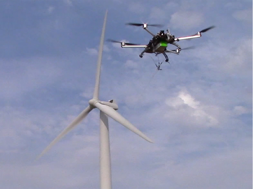
As an early test of CTEMPs’s capabilities combining drones and DTS, investigators from Oregon State University and the University of Nevada, Reno, brought a fleet of drones to an active wind farm. The drones lifted a DTS fiber to a height of 120 meters, gathering temperature profiles once every second at a resolution of 0.1 meters to quantify the dynamics of atmospheric mixing caused by large wind farms (see video below).
Investigators from Oregon State University and the University of Nevada, Reno, test
the temperature-measuring capabilities of a fleet of drones at an active wind farm.
Credit: Ziru Liu, Oregon State University
CTEMPs anticipates having a fleet of three aircraft by late summer 2015 capable of 20- to 40-minute flights with payloads ranging from 2 to 4 kilograms. These aircraft will be capable of surveying regions as large as 200 square kilometers over the course of several days, with the exact flight time depending upon the user’s resolution requirements. They will be able to carry lidar and thermal and multispectral sensors and also to capture high-resolution visible imagery.
Using CTEMPs for Your Research
CTEMPs exists for the benefit of the Earth and environmental science community.
CTEMPs exists for the benefit of the Earth and environmental science community, and all workshops, instruments, and advice are available to the research community. It reports to an external advisory panel that includes the Consortium of Universities for the Advancement of Hydrological Sciences, Inc. CTEMPs also collaborates with its sister facilities, including Incorporated Research Institutions for Seismology (IRIS), the University NAVSTAR Consortium (UNAVCO), the National Center for Airborne Laser Mapping (NCALM), and other federal agencies.
A UAS training workshop, focusing on all aspects of a UAS mission from planning to data analysis, was held on 23–25 June 2015, and CTEMPs holds an annual DTS training workshop prior to the American Geophysical Union’s Fall Meeting (scheduled in 2015 for 12–13 December).
Author Information
John Selker, Department of Biological and Ecological Engineering, Oregon State University, Corvallis; Scott Tyler, Department of Geological Sciences and Engineering, University of Nevada, Reno; email: [email protected]; and Chad Higgins and Michael G. Wing, Forest Engineering, Resources and Management Department, Oregon State University, Corvallis
Selker and Tyler are codirectors of CTEMPs. Wing is the director of AirCTEMPs.
Citation: Selker, J., S. Tyler, C. Higgins, and M. G. Wing (2015), Drone squadron to take Earth monitoring to new heights, Eos, 96, doi:10.1029/2015EO035405. Published on 14 September 2015.