
Source: Journal of Geophysical Research: Atmospheres
Warming temperatures in spring herald the melting of snow in mountains and higher-latitude regions. Predicting the timing and speed of snowmelt is important for local communities as they prepare for knock-on effects such as increased river levels or the end of the snow sports season.
Spring snowmelt is predominantly influenced by incoming shortwave radiation (the Sun’s heat reaching Earth’s surface) and incoming longwave radiation (heat emitted from Earth’s atmosphere). However, solar and terrestrial radiations are not simple to measure, as they highly vary in space and time, including at a very localized level.
Consider forested areas that experience seasonal snow cover as an example. Forests are not uniformly vegetated areas; the density of trees can vary, clearings can be different sizes, and man-made features such as a lake or a road can cause sharp forest edges. Different parts of this forested environment experience radiation in different ways. For instance, trees on one side of a clearing will experience more solar radiation in the middle of a sunny day than trees just a few meters away on the opposite side of the open space that are in shadow.
Snowmelt models do not take into account localized spatial (horizontal and vertical) and temporal variability in such “discontinuous forests,” partly because of a lack of data. Webster et al. address this not only with a comprehensive set of measures from a field site but also with suggestions as to how models may need to be adjusted.
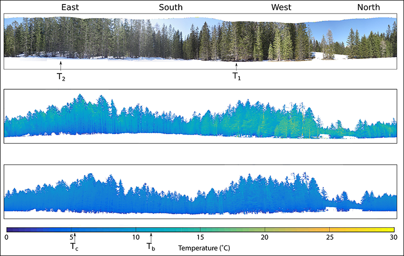
The researchers chose a site in the Swiss Alps and set up an array of devices in a large gap in the forest and in a nearby small gap. They used pyranometers to measure incoming shortwave and longwave radiation, thermistors to gather air temperature data, thermocouples attached to trees to collect trunk temperatures, a fish-eye camera to take optical hemispherical photographs that show the amount of visible sky and are used to estimate solar radiation, and a thermal camera to take 360° panoramas around the forest gaps and measure canopy surface temperatures. They also incorporated lidar data from helicopter flyovers for canopy classification.
Their data collection during two snowmelt seasons revealed some dramatic spatial and temporal variations. For example, during clear-sky conditions, the canopy temperature measured in the shaded edges of the large gap was 20°C colder than the sunlit edges.
Models generally use air temperature as a proxy measure for canopy temperature, but the team showed that this is not always an accurate assumption. Their findings suggested that air temperature was a good representation of canopy temperature on cloudy days and in closed canopy environments on clear-sky days but not around forest edges on sunny days or during the night.
The adjustment to snowmelt models that the researchers propose to take this into account could be applied to similar European midlatitude alpine sites with discontinuous coniferous forest but would need some calibration. For example, other environments would have different forest types in an alpine region or areas in the shadow of a mountain. However, the authors suggest that calibration could be easily achieved using one pair of radiometers to ascertain the relationship between canopy temperature and air temperature in that locality.
The boreal and subalpine forests of the Northern Hemisphere are changing. In particular, they are becoming increasingly discontinuous because of land use change, forest fires, climate change, and other factors. With these forests’ seasonal snow cover estimated to account for up to 17% of terrestrial water storage, understanding the influence of localized spatial and temporal variabilities in response to incoming radiation and accounting for these in snowmelt models become all the more pertinent. (Journal of Geophysical Research: Atmospheres, https://doi.org/10.1002/2017JD026581, 2017)
—Jenny Lunn, Contributing Writer
Citation:
Lunn, J. (2017), How the micrometeorology of Alpine forests affects snowmelt, Eos, 98, https://doi.org/10.1029/2017EO082705. Published on 25 September 2017.
Text © 2017. The authors. CC BY-NC-ND 3.0
Except where otherwise noted, images are subject to copyright. Any reuse without express permission from the copyright owner is prohibited.