
An engineer in Iceland checks the pressure levels of geothermally heated water running through a power plant’s turbines. A cowherd in the Azores leads livestock to a pasture perched on a rolling hillslope. A tourist slathers on sunscreen on the crowded shores of Tenerife in the Canary Islands. A farmer harvests maize in Garrotxa, a county in Spain’s autonomous community of Catalonia.
The engineer, cowherd, tourist, and farmer all have an important aspect in common: High above the landscapes that supply them with work and entertainment loom slumbering volcanoes.
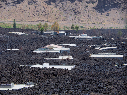
Around the world, more than 500 million people live in areas that expose them to volcanic hazards.
Around the world, more than 500 million people live in areas that expose them to volcanic hazards. To help protect them, hazards experts contemplate scenarios. Could a debris flow triggered by the volcano inundate nearby towns? What if it blocked water supplies? Could we anticipate where such a flow would go? How much lead time could we get to evacuate inhabitants?
People in the shadow of an active volcano depend on early warnings of volcanic unrest from their civil authorities. These authorities, in turn, rely on scientists to supply them with critical information. Ideally, officials have close and efficient collaboration as well as effective communication with scientists, who provide them with accurate assessments of innate hazards and who recommend practical strategies to reduce risk.

The real world, however, is far from ideal. Past eruptive events offer several examples of failed communications between scientists and first responders or decision makers. A tragic example is the 1985 eruption of Colombia’s Nevado del Ruiz, in which more than 23,000 people lost their lives, partly because local governments did not consider the warnings of scientists who knew the volcano was awakening.
An important goal for improving the management of volcanic crises is to develop objective, real-time methodologies for evaluating how an emergency will develop and how scientists communicate with decision makers. Scientists need to know what first responders expect from them and should build a system to transmit scientific results. At the same time, first responders need to know the limits of science.
To facilitate collaboration, physical and social scientists developed VeTOOLS, a project that integrates in a systematic and sequential way a series of well-tested tools addressing various aspects of the volcanic hazard assessment process. Using VeTOOLS, experts provide community planners with long-term hazard assessments and vulnerability analysis during quiescent times and supply first responders with short-term hazard assessments and cost-benefit analysis as unrest unfolds.
A Disconnect Between Scientists and First Responders
Modern assessments of volcanic hazards rely on probabilistic approaches, where volcanologists develop models that combine eruptive scenarios and their expected recurrence with information on population distribution, infrastructure vulnerability, and other factors that help calculate risks to the general public. With these models, decision makers can conduct a holistic analysis of a volcanic crisis, including assessments of costs versus benefits.
Scientists and civil authorities do not always work sufficiently closely to enable the authorities to always understand the science behind hazard assessments. Also, the scientific community has not always clearly understood the needs and exact requirements of officials.
As a result, the collaboration between scientists and community planners is not always as successful as it could be. Scientific literature offers a considerable number of methodologies and tools addressing hazard assessment. However, community planners sometimes prefer to use their own approaches and ignore these methodologies and tools, which end up being only a good academic exercise.
Because probabilistic methodologies play such a prominent role in volcanic hazard assessment, scientists seek to develop methodologies and protocols to bridge this disconnect. These methods aim to provide better scientific support to the civil authorities who must base their decisions on them. In this vein, VeTOOLS was born.
The VeTOOLS Project
In volcanology, e-tools—computer or Web-based applications intended to make a task easier—can help users employ probabilistic methods to assess and forecast volcanic eruptions and their likelihood of occurrence. For example, the VHub collaboration site offers a good choice of freely available models and methodologies. However, VHub’s resources are not integrated into a single platform that can homogenize programming languages and facilitate their systematic use and guidance in hazard assessment.
The VeTOOLS project, which seeks to develop and implement e-tools for volcanic hazard assessment and risk management, goes a step forward in creating and integrating software packages. This integration can facilitate collaboration between community officials and scientists in conducting effective hazard assessments and in helping decision makers develop emergency programs and manage volcanic crises.
A Simple, Multiplatform Method
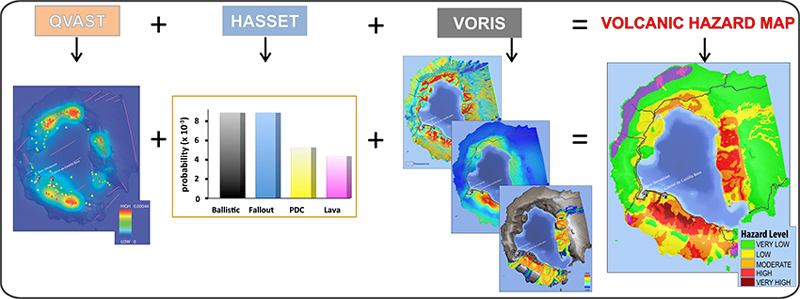
Scientists involved with VeTOOLS created a simple multiplatform method (VOLCANBOX), capable of running on Windows, Mac OS X, and Linux, for assessing hazards and risks. It includes a series of e-tools that allow experts to evaluate the possible hazards that could affect a volcanic area and develop appropriate hazard and risk maps. In short, VOLCANBOX allows experts to assess information and package it into a form that community planners need.
Currently, the VOLCANBOX platform includes a database design (using Volcanic Management Risk Database Design (VERDI), an open platform for debugging computer code [Bartolini et al., 2014a]) created to structure and store all data necessary to conduct hazard assessment. The database is contained in five modules: spatial analysis, temporal analysis, simulation models, risk analysis, and communication protocols (Figure 1).

Each of these modules includes different e-tools already developed by Spain’s research council (Consejo Superior de Investigaciones Científicas (CSIC)). These tools include Quantum Geographic Information Systems (GIS) for Volcanic Susceptibility (QVAST) [Bartolini et al., 2013], which provides quantitative assessments of a new eruptive vent; Hazard Assessment Event Tree (HASSET) [Sobradelo et al., 2014], an event tree structure that uses Bayesian inference to estimate the probability of occurrence of a future volcanic scenario; Volcanic Risk Information System (VORIS) [Felpeto et al., 2007], a GIS-based tool that allows users to simulate lava flows, fallout, and pyroclastic density current scenarios; Volcanic Damage (VOLCANDAM) [Sciani et al., 2014], which generates maps that estimate the expected damage caused by volcanic eruptions; and Bayesian Decision Model (BADEMO) [Sobradelo and Martí, 2015], which enables a previous analysis of the distribution of local susceptibility and vulnerability to eruptions to be combined with specific costs and potential losses.
We are working to integrate other tools or models that have been developed by other authors. Also, we intend to offer experts different options based on the available input data they may have and the accuracy they require.
Applying the Tools
VOLCANBOX is a resource to build the strategies required to successfully confront and minimize the impact of future volcanic eruptions in a homogeneous and systematic way (Figure 2).
Experts select the tools in each module that they want to apply in a sequential workflow. The nature of this workflow can be adapted to a long- or short-term hazard assessment, and it takes the different tasks assumed in the volcanic management cycle as a reference.
For a long-term hazard assessment, for example, the user could obtain a susceptibility map (spatial analysis, e.g., QVAST) showing the probability of where a new vent will form on a volcano, a temporal analysis of the occurrence of possible eruptive scenarios (e.g., HASSET), a simulation of possible volcanic and associated hazards and elaboration of qualitative and quantitative hazard maps (e.g., VORIS), vulnerability analysis (e.g., VOLCANDAM), and cost-benefit analysis to determine the most appropriate mitigation measures (e.g., BADEMO).
In the case of a short-term analysis (covering a single unrest episode), we would use the previous results and add monitoring information through the use of a specific tool (e.g., ST-HASSET) [Bartolini et al., 2016] to refine the spatial and temporal constraints of the most probable scenarios.
Connecting to Civil Protection
VeTOOLS also looks at how to make scientific information understandable for decision makers and community planners who manage risk in volcanic areas. Through step-by-step instructions, scientists using VOLCANBOX show community planners how to identify the most probable eruptive scenarios and their potential effects, which helps officials triage emergency responses in the event of an eruption. These instructions were developed after testing VOLCANBOX with civil protection agencies in Spain, the Azores, and Iceland.
Before using VOLCANBOX, experts must engage community planners to discover what they need.
As of now, however, scientists must use VOLCANBOX and then deliver assessments to community officials, and it is incumbent on scientists to use VOLCANBOX to gather the information that community officials seek. Thus, before using VOLCANBOX, experts must engage community planners to discover what they need. In this way, experts who effectively use VOLCANBOX will actively work with civil protection agencies to share, unify, and exchange procedures, methodologies, and technologies, thereby reducing the effects of volcanic disasters by improving assessment and management of volcanic risk.
A Versatile Tool Box
VeTOOLS provides an option to improve volcanic risk assessment and management capacities in active volcanic regions by providing an integrated set of e-tools and methodologies to conduct long- and short-term hazard assessment.
It is even possible that the application of VOLCANBOX will help identify differences between the levels of hazard assessment in various volcanic areas and possible existing gaps in the basic information (e.g., census data, maps of key infrastructure) required to conduct volcanic risk management, regardless of local specific features. VOLCANBOX, if used at volcanoes across the globe, may help reveal such gaps.
Although volcanic eruptions are infrequent, they present multiple hazards and thus create problems similar to or even greater than those of more frequent natural events. For that reason, the VeTOOLS project is currently working to incorporate into the platform existing tools for assessing potentially related hazards, including earthquakes, landslides, and tsunamis.
Acknowledgments
This research is funded by the European Commission’s Humanitarian Aid and Civil Protection Unit (EC ECHO grant SI2.695524: VeTOOLS).
References
Bartolini, S., A. Cappello, J. Martí, and C. Del Negro (2013), QVAST: A new Quantum GIS plugin for estimating volcanic susceptibility, Nat. Hazards Earth Syst. Sci., 13(11), 3031–3042, doi:10.5194/nhess-13-3031-2013.
Bartolini, S., L. Becerril, and J. Martí (2014a), A new Volcanic management Risk Database design (VERDI): Application to El Hierro Island (Canary Islands), J. Volcanol. Geotherm. Res., 288, 132–143, doi:10.1016/j.jvolgeores.2014.10.009.
Bartolini, S., A. Geyer, J. Martí, D. Pedrazzi, and G. Aguirre-Díaz (2014b), Volcanic hazard on Deception Island (South Shetland Islands, Antarctica), J. Volcanol. Geotherm. Res., 285, 150–168, doi:10.1016/j.jvolgeores.2014.08.009.
Bartolini, S., R. Sobradelo, and J. Martí (2016), ST-HASSET for volcanic hazard assessment: A Python tool for evaluating the evolution of unrest indicators, Comput. Geosci., 93, 77–87, doi:10.1016/j.cageo.2016.05.002.
Felpeto, A., J. Martí, and R. Ortiz (2007), Automatic GIS-based system for volcanic hazard assessment, J. Volcanol. Geotherm. Res., 166, 106–116, doi:10.1016/j.jvolgeores.2007.07.008.
Scaini, C., A. Felpeto, J. Martí, and R. Carniel (2014), A GIS-based methodology for the estimation of potential volcanic damage and its application to Tenerife Island, Spain, J. Volcanol. Geotherm. Res., 278–279, 40–58, doi:10.1016/j.jvolgeores.2014.04.005.
Sobradelo, R., and J. Martí (2015), Short-term volcanic hazard assessment through Bayesian inference: Retrospective application to the Pinatubo 1991 volcanic crisis, J. Volcanol. Geotherm. Res., 290, 1–11, doi:10.1016/j.jvolgeores.2014.11.011.
Sobradelo, R., S. Bartolini, and J. Martí (2014), HASSET: A probability event tree tool to evaluate future volcanic scenarios using Bayesian inference presented as a plugin for QGIS, Bull. Volcanol., 76, 770, doi:10.1007/s00445-013-0770-x.
Author Information
Joan Martí, Stefania Bartolini, and Laura Becerril, Volcanology Group, Institute of Earth Sciences Jaume Almera, Consejo Superior de Investigaciones Científicas, Barcelona, Spain; email: [email protected]
Citation:
Martí, J.,Bartolini, S., and Becerril, L. (2016), Enhancing safety in a volcano’s shadow, Eos, 97, https://doi.org/10.1029/2016EO054161. Published on 21 June 2016.
Text © 2016. The authors. CC BY-NC-ND 3.0
Except where otherwise noted, images are subject to copyright. Any reuse without express permission from the copyright owner is prohibited.