Geothermal energy is one of several renewable, reliable sources that can drive transitions from fossil fuels. Compared with other renewable energy sources like solar and wind, geothermal is more constant in time and does not depend on season, time of day, or weather conditions. The most substantial geothermal resources are usually found near active tectonic plate boundaries or volcanic regions [Limberger et al., 2018], and one of the most promising prospects, globally, for geothermal exploration and production is the East African Rift System (EARS).
Early estimates indicated that East African countries (Burundi, Comoros, Djibouti, Democratic Republic of the Congo, Eritrea, Ethiopia, Kenya, Rwanda, Malawi, Mozambique, Tanzania, Uganda, and Zambia) could potentially generate 15,000 to 20,000 megawatts of geothermally sourced electricity [Zemedkun, 2018]. This supply could support rapidly growing regional economies as they transition from imported fossil fuels to more local and sustainable energy sources.
Here we describe an ongoing research project that is part of a capacity-building program led by the Kenya Electricity Generating Company PLC (KenGen) in Kenya and the University of Twente in the Netherlands. The main goal of this project is to understand the convective “motor” that governs heat transport within Kenya’s highly productive Olkaria geothermal field and its responses to long-term energy extraction and seasonal and climatic changes. The project aims to provide geoscientific knowledge to support the management of existing production wells and planning of future drilling operations in newly developed areas.
Energy from Olkaria
In 1981, Kenya became the first African country to use geothermal energy from the EARS, and so far, it has been the most successful.
The EARS (Figure 1a) is an intracontinental rift system that extends through several countries, from the Red Sea and the Gulf of Aden to Mozambique and Botswana. Seismicity associated with this system extends even farther south [Fadel et al., 2020]. The EARS comprises several discrete rift segments, some with and some without magmatic surface expressions, that started developing between the late Oligocene and early Miocene (~25 million–20 million years ago).
Kenya began exploring for geothermal resources in 1950. In 1981, it became the first African country to use geothermal energy from the EARS, and so far, it has been the most successful. Kenya ranks eighth globally in terms of geothermal energy utilization, with an installed geothermal capacity of 865 megawatts electric (MWe, distinct from power from thermal energy), about 29% of the country’s total installed electricity capacity in 2019 [Omenda et al., 2020].
Geothermal exploration and exploitation activities in Kenya are concentrated along the Kenya Rift System, the Kenyan part of the EARS (Figure 1b). The Kenya Rift System runs north to south and is characterized by the presence of Quaternary volcanic centers (i.e., younger than about 2.6 million years) along its margin, with older centers located farther north and younger ones to the south.

The Kenya Rift System covers a large area, although most geothermal energy production in Kenya comes from a single field, the Olkaria geothermal field. The Olkaria field was, and still is, ranked the highest in resource potential in Kenya. It has been under development and exploitation since 1981. Production from Olkaria has increased from an initial 15 MWe to about 862.5 MWe today [Omenda et al., 2020]. The part of the Olkaria field operated by KenGen produces roughly 700 MWe, about 81% of total geothermal production and about 20% of the total energy production of Kenya [Omenda et al., 2020].
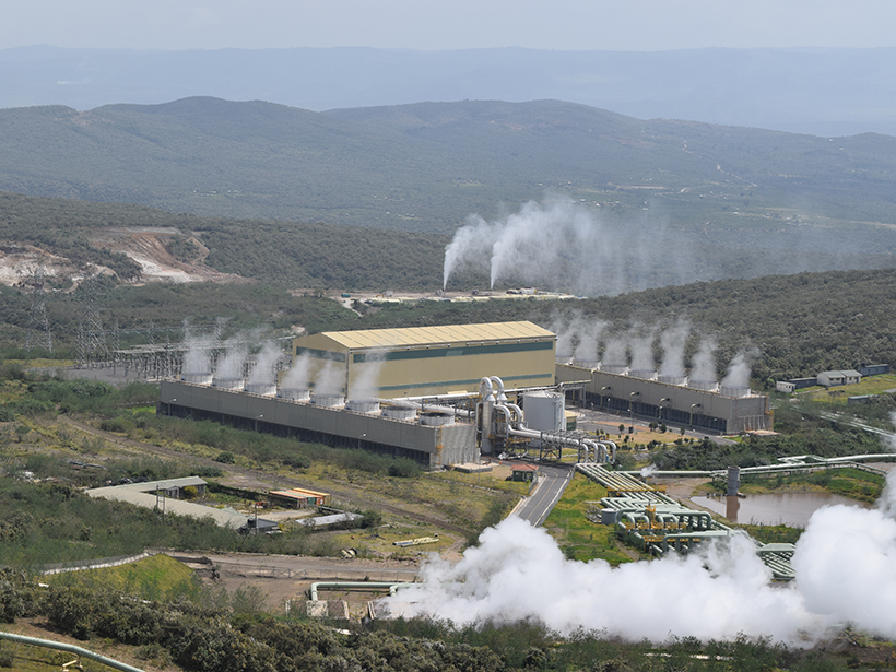
Other geothermal fields in Kenya at different stages of development include the Eburru, Menengai, and Paka-Silali geothermal prospects (Figure 1b). However, the electrical power they supply is still far from the production capacity of Olkaria. Although the geothermal resources of Olkaria are mainly used for electricity generation, heat from the field is also used directly for local flower farming and for recreational purposes, including at the hot geothermal spa in the area.
Olkaria, a high-enthalpy (i.e., high-temperature) geothermal system, depends on a magmatic heat source, a permeable reservoir of volcanic rocks (rhyolites as well as trachytes and basalts) and fluids that can be extracted from and injected into the reservoir (Figure 2). The system has a clay cap of hydrothermally altered rocks that overlie the top of the reservoir and keep the hot fluids contained. Large-scale convection within the reservoir circulates fluid upward along upflow zones, whereas cooled fluids, as well as meteoric water (rainfall and other precipitation), circulate downward to recharge the reservoir. Operating like a “geothermal motor,” this convection carries heat from deeper parts of the subsurface to shallower parts, where it can be extracted through geothermal production wells.

Geothermal Motor Maintenance
Attention is now shifting to monitoring and understanding the geothermal motor, crucial activities for the long-term sustainability of the system.
Intensive research has helped to evaluate the resource potential of the Olkaria field. Attention is now shifting to monitoring and understanding the geothermal motor, crucial activities for the long-term sustainability of the system. Steam drives electricity generation at Olkaria, and the separated liquid phase and power plant condensates are reinjected back to the reservoir. However, the overall mass of extractions from the reservoir exceeds that which is reinjected. If this mass imbalance is not carefully managed in the long term, it could negatively affect reservoir pressure and the extractable power production of the system.
One potential negative effect of geothermal production is unintended changes to the speed and efficiency of the geothermal motor. Such changes also occur naturally—the activity of geothermal motors (and associated heat fluxes measured at the surface) has been observed globally to vary over timescales of thousands of years [e.g., Sturchio et al., 1993], decades [e.g., Mia et al., 2012], and even seasonally [e.g., Ingebritsen et al., 2001]. Studies have suggested that the availability of precipitation (or snowmelt in colder climates) to recharge deeper reservoirs can cause short-term heat flux variations at the surface [e.g., Vaughan et al., 2012], but no statistically significant link between precipitation and heat flux has been established to date. We postulate that apart from variable rainfall patterns, changes in extraction rates of geothermal fluids could also alter the filling level of the reservoir, which could cause the geothermal motor to run at different speeds.
Monitoring and understanding the geothermal motor at Olkaria, or any geothermal field, necessitate a long-term observation strategy that includes an in situ system of sensor, fluid production, and geohazards data from the field operator as well as airborne and satellite-based Earth observations. Such a multisensor monitoring system would ideally capture the system dynamics and provide information on variations in surface and subsurface temperatures, subsurface fluid pressures in extraction wells, and the relation of these parameters to fluid extraction and recharge rates.
A long-term observation strategy should address three fundamental questions:
- What is the effect of exploitation for energy production on the functioning of a geothermal system?
- On what time frame does this exploitation lead to potential resource depletion?
- How does the geothermal motor of this geothermal system fluctuate seasonally and as a function of climatic variations?
Answering these fundamental questions clearly requires a multidisciplinary approach because geothermal systems are physically complex, involving interactions among meteorological, hydrological, and geological parameters.
The Olkaria Field Lab
The field lab extends over a 32-square-kilometer area and covers sections of the greater Olkaria area.
The Olkaria field lab is an in situ integrated system of sensors consisting of seismic stations, time-lapse and thermal cameras, and a meteorological station (Figure 2a). The goal of this monitoring is to capture variations in physical properties of the subsurface, surface, and atmosphere that provide information about the geothermal motor. The field lab extends over a 32-square-kilometer area and covers sections of the greater Olkaria area on either side of Ol Njorowa Gorge, including the Olkaria East field (which encompasses the Ololbutot lava field) and the newly developed Olkaria Domes field.
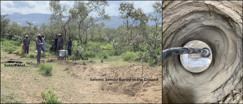
The subsurface component consists of 15 broadband seismic stations spaced 2–3 kilometers apart on average: ten 120-second posthole seismometers buried to about 2 meters depth (Figure 3), one surface 120-second seismometer placed on a concrete slab and covered by housing, and four 30-second surface seismometers. This network is designed to cover the Olkaria Domes field as well as the main faults going through the area and especially Ol Njorowa Gorge, which separates the fluid regimes (Figure 2b) of the “domes” subarea (southeast of the fault) from that of the “lava field” (northwest of the fault). The seismic instruments continuously monitor the Olkaria field to detect both local and distant earthquakes (Figure 4) and to monitor variations in the ambient seismic noise field.

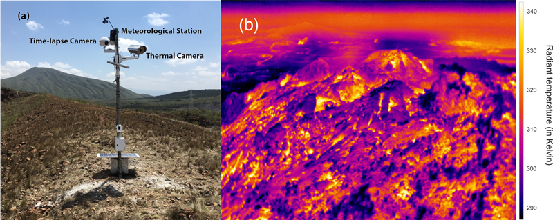
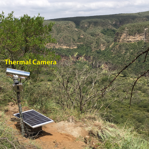
The surface component of the field lab consists of two thermal cameras that are strategically located to monitor active hot spot areas. One camera (OMF8 in Figure 2a) is aimed at a fumarole in the lava field in the western part of the study area and is also equipped with a time-lapse camera to measure surface deformation (Figure 5a). Thermal images are acquired 24 times a day at the top of each hour by this station (Figure 5b). Another camera (OMF6) is located on a cliff east of Ol Njorowa Gorge and is aimed at a fumarole in the gorge (Figure 6).

The atmospheric component consists of a meteorological station installed in the lava field with thermal camera OMF8 (Figure 5a). This station continuously monitors air temperature, rainfall, wind, soil moisture, and solar irradiance.

A Unified Model from Multiple Data Sets

Olkaria field lab has been investigating the intricacy of the geothermal motor at the Olkaria field since September 2019, and this project will continue for a number of years (an initial period of 2 years followed by a scientific evaluation). Measurements from the field lab will be integrated with well logs, production data, and freely available satellite radar data from the European Space Agency’s Sentinel-1 and thermal infrared data from NASA’s ECOSTRESS (Ecosystem Spaceborne Thermal Radiometer Experiment on Space Station) mission to monitor water circulation and temperature variation of the geothermal motor.
Given the complexity of the Olkaria system and this integrated approach, we will monitor the system dynamics using a step-by-step integration scheme to process data sets from the different sensors. Time-lapse observations from the sensors observing the surface and the atmosphere will be correlated with the subsurface variations caused by production activities or that occur in reaction to them. Once we confirm the sensitivity of the data sets to detect changes in the geothermal motor, all the data will be used simultaneously to create 3D and 4D images of the system and its dynamic changes.
We aim to develop a systematic approach that can also be used to monitor other geothermal systems (or similarly dynamic Earth systems) throughout the world.
In this work, we aim to develop a systematic approach that can also be used to monitor other geothermal systems (or similarly dynamic Earth systems) throughout the world. Integration of data products from the subsurface, surface, and atmosphere will lead to unified images of system dynamics and enable further understanding of Olkaria and other geothermal systems. We expect this understanding will provide insights into how such systems respond to production and exploitation activities like fluid extraction and recharge, for example, as well as to seasonal changes in rainfall patterns.
Such fundamental knowledge should facilitate optimal management and maintenance of geothermal systems in the Olkaria field and elsewhere and should improve the sustainability of these energy resources for years to come.
Acknowledgments
This work is financially supported by a scientific collaboration agreement between Kenya Electricity Generating Company PLC and the University of Twente, Netherlands. We thank the geophysics and geochemistry teams at KenGen who made a great effort to support the installation of the field lab. The authors also thank Benno Masselink (University of Twente) for assistance with the figures.
References
Fadel, I., et al. (2020), Crustal and upper mantle shear‐wave velocity structure of Botswana: The April, 3, 2017, central Botswana earthquake linked to the East African Rift System, Geophys. Res. Lett., 47, e2019GL085598, https://doi.org/10.1029/2019GL085598.
Ingebritsen, S., et al. (2001), Time-variation of hydrothermal discharge at selected sites in the western United States: Implications for monitoring, J. Volcanol. Geotherm. Res., 111, 1–23, https://doi.org/10.1016/S0377-0273(01)00207-4.
Limberger, J., et al. (2018), Geothermal energy in deep aquifers: A global assessment of the resource base for direct heat utilization, Renewable Sustainable Energy Rev., 82, 961–975, https://doi.org/10.1016/j.rser.2017.09.084.
Mia, M. B., C. J. Bromley, and Y. Fujimitsu (2012), Monitoring heat flux using Landsat TM/ETM+ thermal infrared data—A case study at Karapiti (‘Craters of the Moon’) thermal area, New Zealand, J. Volcanol. Geotherm. Res., 235, 1–10, https://doi.org/10.1016/j.jvolgeores.2012.05.005.
Omenda, P., et al. (2020), Country update for Kenya 2015-2019, paper presented at World Geothermal Congress 2020, Int. Geotherm. Assoc., Reykjavik, pangea.stanford.edu/ERE/db/WGC/Abstract.php?PaperID=4876.
Sturchio, N. C., P. Dunkley, and M. Smith (1993), Climate-driven variations in geothermal activity in the northern Kenya rift valley, Nature, 362(6417), 233–234, https://doi.org/10.1038/362233a0.
Vaughan, R. G., et al. (2012), Use of ASTER and MODIS thermal infrared data to quantify heat flow and hydrothermal change at Yellowstone National Park, J. Volcanol. Geotherm. Res., 233, 72–89, https://doi.org/10.1016/j.jvolgeores.2012.04.022.
Zemedkun, M. T. (2018), Geothermal outlook in East Africa and Contribution of UNU-GTP in capacity building, paper presented at United Nations University Geothermal Training Programme (UNU-GTP), 40th Anniversary Workshop, U. N. Educ., Sci. and Cultural Organ., Reykjavik, orkustofnun.is/gogn/unu-gtp-40-ann/UNU-GTP-40-A-1-Meseret-Teklemariam.pdf.
Author Information
Islam Fadel ([email protected]) and Christoph Hecker, Faculty for Geo-Information Science and Earth Observation, University of Twente, Enschede, Netherlands; Junior Kimata, Faculty for Geo-Information Science and Earth Observation, University of Twente, Enschede, Netherlands; also at Kenya Electricity Generating Company PLC, Olkaria, Naivasha; Eunice Bonyo, Kenya Electricity Generating Company PLC, Olkaria, Naivasha; and Mark van der Meijde, Harald van der Werff, and Freek van der Meer, Faculty for Geo-Information Science and Earth Observation, University of Twente, Enschede, Netherlands
Citation:
Fadel, I.,Hecker, C.,Kimata, J.,Bonyo, E.,van der Meijde, M.,van der Werff, H., and van der Meer, F. (2021), Geoscientific monitoring of Olkaria’s geothermal motor, Eos, 102, https://doi.org/10.1029/2021EO153904. Published on 28 January 2021.
Text © 2021. The authors. CC BY-NC-ND 3.0
Except where otherwise noted, images are subject to copyright. Any reuse without express permission from the copyright owner is prohibited.

