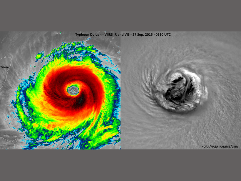
More than 300 scientists gathered for the second Center for Satellite Applications and Research (STAR) Joint Polar Satellite System (JPSS) Annual Science Team Meeting. Participants contributed nearly 200 presentations and 60 posters, representing all aspects of the JPSS program and the polar satellite product user community.
JPSS is the next generation of polar-orbiting satellites, run by a collaboration between the National Oceanic and Atmospheric Administration (NOAA) and NASA. The mission relies on five high-resolution instruments to provide daily global retrievals of various properties of Earth’s surface and atmosphere. In October 2011, scientists launched the initial satellite, Suomi National Polar-orbiting Partnership (NPP). The next, JPSS-1, is due for launch in early 2017.
Cloud, atmosphere, ocean, land, and cryosphere algorithm data products provide the community with continuity of critical observations for accurate weather and climate forecasting and advanced ocean ecosystem modeling.
This meeting focused on satellite data products. It brought algorithm developers together with the user community to optimize both the development and use of those data products. Cloud, atmosphere, ocean, land, and cryosphere algorithm data products provide the community with continuity of critical observations for accurate weather and climate forecasting and advanced ocean ecosystem modeling.
At this meeting, participants provided briefings in plenary sessions, and targeted breakout sessions allowed science teams to go in depth to evaluate product readiness; interact directly with external members, cooperative institutes, and other agencies; and provide a forum to coordinate data processing and archival needs. Discussions included lessons learned from our Suomi NPP algorithm development, calibration, and validation experience, so that we can further improve our development process for JPSS-1.
Presentations continuously confirmed that JPSS data have inspired a wide array of new research. We agreed that NOAA’s continued efforts to provide transparent algorithm development, seamless algorithm integration, automated long-term product monitoring, science quality data reprocessing, and consistent and well-documented archiving contribute to the success of these endeavors.
Users and the broader JPSS community produced several recommendations at the meeting:
- move toward developing enterprise algorithms that can be run using data from any of NOAA’s polar or geostationary satellites
- produce optimal and reliable data products from a fusion of U.S. and worldwide polar and geostationary satellite constellations, programs, and systems across public and private domains
- develop the science-quality data processing necessary for internal calibration and validation activities and for users
- work toward the global unification of calibration and validation processes and maturity definitions of products derived from a variety of satellite platforms from the many worldwide Earth observation satellite data providers
Teams dispersed throughout the country were able to meet face to face, helping to resolve issues and ambiguities while strengthening collaborative efforts.
The meeting was a success, with enough breadth to cover the overall JPSS algorithm and calibration/validation efforts and in-depth presentations proving that the program is well prepared for the launch of JPSS-1. Teams dispersed throughout the country were able to meet face to face, helping to resolve issues and ambiguities while strengthening collaborative efforts. Positive feedback from team members, users, and JPSS management indicates that the objectives envisioned for the meeting were fulfilled. The next meeting will be held in College Park, Md., from 8 to 12 August 2016.
—Lihang Zhou, Center for Satellite Applications and Research, National Oceanic and Atmospheric Administration, College Park, Md.; email: [email protected]; and Murty Divakarla and Tom Atkins, IM Systems Group Inc., Rockville, Md.
Citation: Zhou, L., M. Divakarla, and T. Atkins (2016), Joint Polar Satellite System algorithm team reviews past, future, Eos, 97, doi:10.1029/2016EO048843. Published on 28 March 2016.
Text not subject to copyright.
Except where otherwise noted, images are subject to copyright. Any reuse without express permission from the copyright owner is prohibited.
Text not subject to copyright.
Except where otherwise noted, images are subject to copyright. Any reuse without express permission from the copyright owner is prohibited.

