Earth’s magnetism is a complex, dynamic phenomenon, resulting from the motions of charged particles in the core, mantle, and ocean, as well as from static magnetic materials in the crust.
Although geoscientists have known for nearly two centuries that the Earth behaves like a magnet, they are still unraveling many mysteries.
Although geoscientists have known for nearly two centuries that the Earth behaves like a magnet, they are still unraveling many mysteries. For instance, how is the magnetic field generated and sustained by the Earth’s outer core, and how much do the planet’s mantle and crust contribute to the overall magnetic field? And what can variations in the geomagnetic field tell us about its interactions with solar and interplanetary magnetic fields as well as what’s under the surface?
Answers to these questions are of interest not just to academics. They can also help prospectors looking for minerals or oil, and they are critical to protecting assets such as satellites from solar storms. But getting a precise map of the Earth’s magnetism requires robust sources of data spanning the planet.
Such data are lacking over many areas of the world. A new initiative, Uniting and Networking the Magnetic Community in the Northern Indian Ocean Region (MAGNIO), is now trying to fill a geomagnetic data gap in one of the world’s least surveyed areas: the northern Indian Ocean.
A Magnetic World
Researchers monitor variations in the geomagnetic field from the ground or from space. The gathered data, along with improved modeling techniques, enable scientists to produce precise estimates of contributions to the overall geomagnetic field from the ocean, crust, mantle, and core. Input data from locations evenly distributed over the globe are critical for a well-defined and realistic model of geomagnetism [Christensen and Olsen, 2003; Sabaka et al., 2004].
Scientists use magnetic field anomalies to explore for minerals in the crust, delineate ocean currents, monitor field variations in real time for drilling applications, and prospect for oil and gas in off-shore areas. Scientists also try to model the variations of the geomagnetic field to assess how baseline readings skew navigation and to protect satellite- and ground-based technology from the effects of magnetic disturbances in the Earth’s magnetosphere and ionosphere resulting from solar storms.
Sparse Data
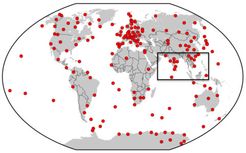
Some parts of the globe, especially Europe, have dense networks of geomagnetic monitors. But other regions produce little geomagnetic data. One of these is the northern Indian Ocean (NIO), a region encompassing 18 million square kilometers that although prone to significant magnetic field variations, hosts relatively few (around 20) observatories with stable data series. Compounding the shortage of facilities, technical and other problems have caused breaks in data records at many of the region’s existing magnetic observatories.
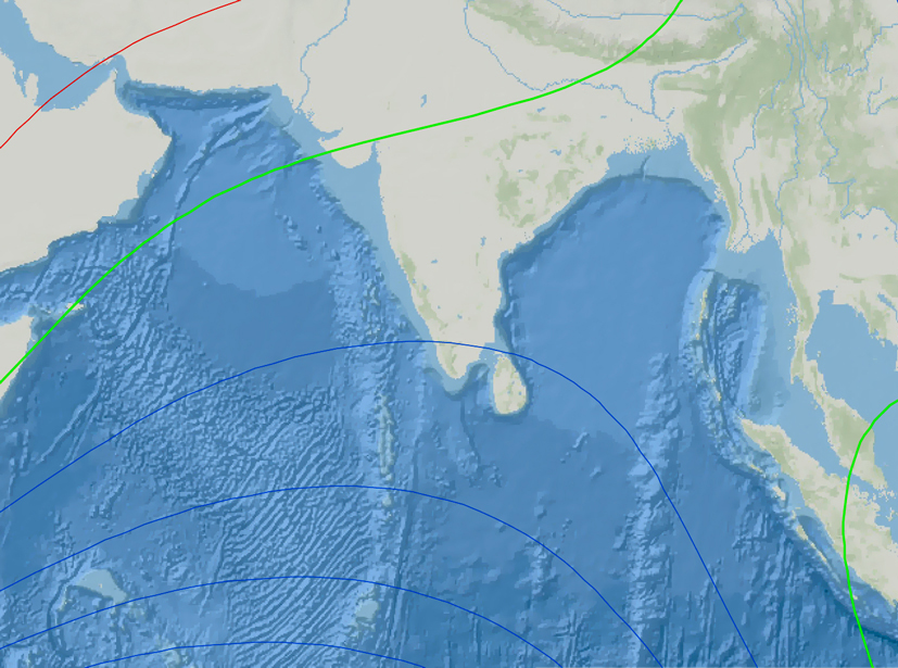
The Northern Indian Ocean is a prime location to estimate and model the effects of several important geomagnetic phenomena.
This sparse data coverage is especially unfortunate because the NIO is a prime location to estimate and model the effects of several important geomagnetic phenomena, such as the equatorial electrojet—a daytime ribbon of east-west current within the ionosphere that flows roughly along the magnetic equator (where magnetic inclination is zero). The region is also a good place to study solar quiet currents, which are generated by worldwide solar-driven winds in the ionosphere and result in a daily enhancement of magnetic fields [Pedatella et al., 2011; Onwumechili, 1997].
Magnetic variation in the NIO also contains the signals of electromagnetic induction caused by the ocean waters as well as subsurface conductive bodies, which most commonly are associated with the presence of fluids or thermal anomalies in the crust and mantle. Thus, study of the magnetic field could also help geologists decipher the crust-mantle configuration associated with the Indian Ocean geoid low (where the Earth’s surface deviates from the ellipsoidal shape by more than 100 meters) and the Andaman-Sumatra subduction zones, which produce megaearthquakes and tsunamis [Kuvshinov, 2008].
When combined with data from the European Space Agency’s satellite-based Swarm Mission, a constellation of three satellites carrying highly accurate magnetometers, concurrent ground measurements could be especially valuable in helping scientists resolve structures of the shallow subsurface and fine details of the ionosphere.
Existing Regional Initiatives in the NIO
Several countries in this region, including India, Pakistan, Myanmar, Indonesia, Sri Lanka, and Vietnam (Figure 1), have long made magnetic measurements for different applications. These countries’ geological and meteorological agencies produce maps of magnetic field anomalies for exploration, identify short–time scale variations in the local magnetic field, and build continuous observatories and arrays for studying source fields and electromagnetic induction occurring in the Earth’s crust.
In 2010 the National Geophysical Research Institute of the Council of Scientific and Industrial Research (CSIR-NGRI) in India along with other partners initiated a project for continuous measurement of magnetic variations at islands in the northern Indian Ocean. At present five island observatories are operating, three in the Andaman-Nicobar region and two in the Lakshadweep-Maldives area.
The new data have produced encouraging preliminary results, highlighting links between variability of magnetic variations and ionosphere-atmosphere interactions [Hamid et al., 2014; Chandrasekhar et al., 2014], as well as correlations between subsurface geometry and models of induced response of ocean-continent boundaries [Samrock and Kuvshinov, 2013].
MAGNIO: A Regional Network
In recognition of efforts to expand the geographical range of magnetic observations, the International Council of Science (ICSU) awarded funding to the International Union of Geodesy and Geophysics (IUGG), with the goal of uniting and networking the magnetic community in the northern Indian Ocean region. The IUGG project team includes researchers from CSIR-NGRI in India, the Indian National Science Academy, the Regional Office for Asia and Pacific in Malaysia, and the World Data Center (WDC) for Geomagnetism at the British Geological Survey in Edinburgh. This core group created the MAGNIO project.
The MAGNIO project aims to establish links between interested agencies—those who use magnetic data for regional interests and global modeling—and those generating data, including nations and institutions that would like to begin or revive magnetic data acquisition procedures. Therefore, both the producers and users of magnetic data need to be identified and linked in this initiative.
Pooling existing data into an integrated database could provide a valuable knowledge base in the region.
Pooling existing data into an integrated database could provide a valuable knowledge base in the region. Such an effort would require the close involvement of agencies that acquire the data.
For example, new ground-based measurements of magnetic variations with a time resolution of 1 minute or better in the NIO region would provide an ideal window of opportunity to augment satellite measurements, which at best record highly accurate but temporally sparse data at a particular position only once in several days.
Strengthened with the addition of continuous time series from ground stations, the satellite data will contribute to models of equatorial magnetic variations.
Such models could be used for diverse scientific and technocommercial activities, including exploration, navigation, satellite communication, and deep drilling. Thus, establishing links between scientists and stakeholders could be mutually beneficial for all.
MAGNIO Objectives
The ICSU Grants Programme supports collaborative scientific initiatives of relevance to science and society through seed funds for the duration of only 1 year. The grant was awarded for 2014–2015, and we plan on using it to leverage funds from other sources.
In addition, we plan to pursue the MAGNIO project goals through a variety of programs and activities:
- running MAGNIO-focused sessions during various international workshops and seminars to bring together data producers and users to discuss issues pertaining to data requirements and the current constraints on acquisition
- documenting and implementing common practices of data acquisition and analysis and consolidating results and findings over the NIO region
- enhancing participation of data acquisition agencies from India, Maldives, Sri Lanka, Indonesia, Thailand, Vietnam, and Myanmar by pooling their data, thereby providing coherent data coverage
- benchmarking magnetic measurements in the region against international standards of observatory practice (as stipulated by the International Real-Time Magnetic Observatory Network (INTERMAGNET))
- seeding a forum or platform that will continue to grow and develop the activities of the current project, so that existing and new observation groups as well as user groups are linked to a coherent regional database
Recent Efforts
Now that MAGNIO has been operating for about a year, several initiatives are well under way. During the XVI International Association of Geomagnetism and Aeronomy (IAGA) Workshop last year, we organized training classes, lectures, and hands-on activities for the benefit of observers from NIO countries and others attending the workshop. Participants from Maldives, Sri Lanka, and India were present. During this workshop several agencies in Europe expressed interest in collaborating with stakeholders in the NIO.
Last year we also made a presentation on the goals and intentions of MAGNIO at the International Conference on Data Sharing and Integration for Global Sustainability (SCIDATACON) Workshop. Participants discussed several issues relevant to geomagnetic data, including how to bring the same standards of visibility, funding, and utility to data archiving and preservation that the research community has achieved with data acquisition.
Future meetings and discussions with stakeholders and collaborators are planned for early next year.
CSIR-NGRI has initiated dialogue with the University of Peradeniya in Sri Lanka to set up a new observatory in that country. Observatories in the Philippines and Indonesia have also expressed interest in being part of the MAGNIO project and subsequent follow-up programs.
Future Steps
In the first phase of MAGNIO operations, we are pursuing the following activities:
- establishing contacts among targeted observatories in the northern Indian Ocean region
- evaluating the observatories in terms of instrumentation, data acquisition, and processing
- defining a scheme and creating documents for upgrading, standardizing, networking, and archiving data from geomagnetic observatories
- planning for a future meeting of representatives from participating observatories
Progress on the above activities is well under way.
We envision that the culmination of the MAGNIO project will be the formation of a forum or consortium that will develop further action plans, depending on priority areas of interest of the participants and availability of funds. We anticipate that this group will do the following:
- make a decision on the recording and delivery of 1-second or 1-minute data
- prepare a website to facilitate compilation of information and easy exchange between participants and to handle technical and scientific queries
- implement the actual processes of upgrading, standardizing, networking, and archiving data
- encourage all participant observatories to upload data to the WDC (Geomagnetism) in Edinburgh
- include the user community in the forum/consortium for appropriate usage of improved products
We recognize that the concept of real-time data sharing is novel to many agencies in the region. However, as we progress with our objectives, the mutual benefits of access should smooth the way to greater collaboration.
We hope to build on this progress so that MAGNIO and the longer-term organization that emerges from it can integrate researchers and users in NIO more fully into the global scientific community, with benefits for all.
References
Chandrasekhar, N. P., et al. (2014), Evidence of short spatial variability of the equatorial electrojet at close longitudinal separation, Earth Planets Space, 66, 110–125.
Christensen, U. R., and P. Olson (2003), Secular variation in numerical geodynamo models with lateral variations of boundary heat flow, Phys. Earth Planet Inter., 138, 39–54.
Hamid, N. S. A., et al. (2014), Relationship between the equatorial electrojet and global Sq currents at the dip equator region, Earth Planets Space, 66, 146–157.
Kuvshinov, A. V. (2008), 3-D global induction in the oceans and solid Earth: Recent progress in modeling magnetic and electric fields from sources of magnetospheric, ionospheric and oceanic origin, Surv. Geophys., 29, 139–186, doi:10.1007/s10712-008-9045-z.
Onwumechili, C. A. (1997), The Equatorial Electrojet, Gordon and Breach, Amsterdam.
Pedatella, N. M., J. M. Forbes, and A. D. Richmond (2011), Seasonal and longitudinal variations of the solar quiet (Sq) current system during solar minimum determined by CHAMP satellite magnetic field observations, J. Geophys. Res., 116, A04317, doi:10.1029/2010JA016289.
Sabaka, T. J., et al. (2004), Extending comprehensive models of the Earth’s magnetic field with Oersted and CHAMP data, Geophys. J. Int., 159, 521–547.
Samrock, F., and A. Kuvshinov (2013), Tippers at island observatories: Can we use them to probe electrical conductivity of the Earth’s crust and upper mantle?, Geophys. Res. Lett., 40, 824–828, doi:10.1002/grl.50218.
Author Information
Kusumita Arora and Nandini Nagarajan, National Geophysical Research Institute, Council of Scientific and Industrial Research, Hyderabad, India; email: [email protected]; Alan Thomson, World Data Centre for Geomagnetism, British Geological Survey, Edinburgh, U. K.; and Alik Ismail-Zadeh, Karlsruhe Institute of Technology, Karlsruhe, Germany, and the Russian Academy of Sciences, Moscow, Russia
Citation: Arora, K., N. Nagarajan, A. Thomson, and A. Ismail-Zadeh (2015), Making the Northern Indian Ocean a hub of geomagnetic data, Eos, 96, doi:10.1029/2015EO034037. Published on 18 August 2015.
Text © 2015. The authors. CC BY-NC 3.0
Except where otherwise noted, images are subject to copyright. Any reuse without express permission from the copyright owner is prohibited.