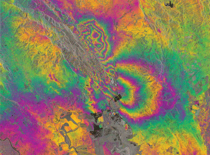
Europe's Sentinel-1A spacecraft and its extraordinary images of slip from the South Napa earthquake herald a new era of space-based surveillance of faults.
Science Updates
Posted inScience Updates
Investigating Climate Change from the Stratosphere to Space
8th Workshop on Long-Term Changes and Trends in the Atmosphere;
Cambridge, United Kingdom, 28–31 July 2014

Posted inScience Updates
Counting the Ocean's Greenhouse Gas Emissions
A new database seeks to improve estimates of oceanic emissions of methane and nitrous oxide.

Posted inScience Updates
Reading History From Afar
A look at the sedimentary record in northern Ethiopia tells the story of oceans past—and maybe future.

Posted inScience Updates
Measurements, Modeling, and Scaling of Inland Water Gas Exchange
Advancing the Science of Gas Exchange Between Fresh Waters and the Atmosphere; Hyytiälä Forestry Field Station, Korkeakoski, Finland, 15–19 September 2014
Posted inScience Updates
Exploring Radioisotopic Geochronology and Astrochronology
IsoAstro Geochronology Workshop: The Integration and Intercalibration of Radioisotopic and Astrochronologic Time Scales;
Madison, Wisconsin, 18–23 August 2014
Posted inScience Updates
Climate, Land Use, and Conflict in Northern Africa
MPI-M/CliSAP Workshop on Climate, Land Use, and Conflict in Northern Africa; Lübeck, Germany, 22–25 September 2014

Posted inScience Updates
New Proposed Drilling at Surtsey Volcano, Iceland
SUSTAIN workshop; Heimaey Island, Iceland, 30 September to 4 October 2014
Posted inScience Updates
Twenty-Five Years of Interdisciplinary Global Change Science
Aspen Global Change Institute Session on Frontiers of Global Change Science;
Aspen, Colorado, 18–22 August 2014
Posted inScience Updates
Integrated Research Approaches to Coastal Zone Management
India-EU Workshop on Coastal Zone Management and Impact on Society;
Alleppey, India, 6–9 October 2014