
The Afar Triangle in northern Ethiopia is one of the harshest, most remote environments on Earth. This tectonically active area contains a record of continents breaking apart; episodes of seas flooding the continent; and the remains of coral reefs, microbial mats, and other saltwater deposits as seas periodically desiccated into brine pools and dry land.

Past investigations have uncovered evidence that this region might become the youngest ocean on Earth. Understanding the sedimentary records in this region may hold clues to the future flooding and carbonate formation in extreme environments.
In October 2013, scientists from Addis Ababa University (Ethiopia), the University of Fribourg (Switzerland), and Ghent University (Belgium) teamed up to learn more about the history of the Danakil Depression in the northern part of the Afar Triangle. Specifically, the team examined sediments, including ancient fringing coral reef terraces and fossilized microbial mats that were covered by brine deposits (evaporites) formed from evaporating oceans and lakes. Since then, the team has worked to examine and understand this sequence of sedimentary rocks and the past environments that formed them.
To the team’s knowledge, this is the first revisiting of northern Afar’s carbonate deposits in almost half a century. As a result of this expedition, the Afar Carbonate Research Consortium was formed as a platform for further research on the sediments in the region. An important follow-on field expedition began in late January 2015.
Afar: A Geological Laboratory
The Danakil Depression is bordered to the west by the Ethiopian Plateau and to the east by the Danakil Horst, a raised block of land bounded by normal faults. In the depression’s southern part lies the famous Erta Ale range, which contains one of the only lava lakes in the world.
![Fig. 1. Location of the study area. MER, Main Ethiopian Rift; D, Dallol region. Black lines represent escarpment boundaries [Keir et al., 2013].](https://eos.org/wp-content/uploads/2015/01/Figs-A-EOS-2014-511.1.15.ai_.jpg)
The depression features the remote Dallol Basin—one of the lowest land elevations on Earth, 130 meters below sea level (see Figure 1). The basin also has year-round temperatures that are among the hottest on the planet. The remnants of a volcanic caldera, Dallol is dotted with hot springs that bubble with brine, as well as geysers, mounds of sulfur, salt pillars, and acid pools.
In the 1960s and 1970s, potash mining operations and coordinated studies of France’s Centre National de la Recherche Scientifique and Italy’s Consiglio Nazionale delle Ricerche preliminarily mapped the sedimentary characteristics of the Danakil Depression [Holwerda and Hutchinson, 1968; Bannert et al., 1971; Barberi et al., 1972]. Since then, geoscience research has largely focused on tectonics, volcanology, and geophysics rather than analytical studies of the basin that integrate tectonics and sedimentation.
This focus on earthquakes and volcanoes is not surprising: Afar is one of the only locations on Earth where rifting at the bottom of an early ocean is creeping up onto land. Ever since the early days of the continental drift theory, geologists have used the Afar Triangle as a field laboratory where the onset of continental and, potentially, oceanic rifting could be studied in detail.
Previous research has pieced together a rough history of this rifting. About 30 million years ago, lava oozed out of cracks in the Earth, blanketing the land and heralding the breakup between Arabia and Africa [e.g., Baker et al., 1972]. After an initial breakup phase, continued rifting in the triangle formed several basins that later closed up and became filled with sediments.
The faults, volcanoes, and magma dikes in the northern part of the triangle run parallel to the regional tectonic trend of the Red Sea [Varet and Gasse, 1978; Wright et al., 2006; Ayele et al., 2007]. They also contain a record of magnetic anomalies similar to those observed along oceanic spreading ridges [Bridges et al., 2012]. Geoscientists project that the region is on its way to becoming the youngest ocean on Earth.
Records of Early and Episodic Marine Flooding

Analysis of sedimentary samples collected during the 2013 field study suggests that the Dallol area was covered by the Red Sea during some time in the past few hundreds of thousands of years. As seawater repeatedly flooded the region, diverse carbonate-rich units were deposited along the edges of the Danakil Depression, covering volcanic rocks below. In the center of the basin are 1000-meter-thick successive evaporite sequences, testimony to the constant evaporation and desiccation of brine pools.
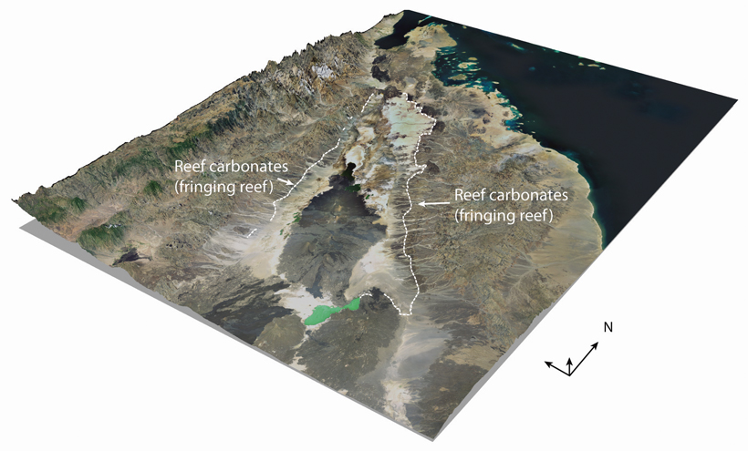
Specifically, the team studied intergrowths of coral and algae called coralgal reefs, relics of the periods when the region was covered by the open Red Sea. Other layers rich in evaporites, microbial reef deposits, and hot spring carbonates show that the same region was covered by hypersaline lakes (brine pools) at different time periods (see Figure 2). Between the coralgal and microbial reefs, shell deposits of only one species of bivalve and one species of gastropod were found, signs that this region alternated between periods of restricted and open marine conditions.
The marine deposits studied by the team consist of at least four superimposed coralgal units. The team found evidence of periods when fringing reefs formed (see Figure 3), separated by eroded layers, suggesting long episodes when no new deposition occurred and possible exposure to the air. Extensive evaporate deposits interspersed between reef carbonates provide further evidence that the oceans periodically dried up in this region.
Future Studies
Previous dating studies based on carbon-14 (δ14C) and isotopic ratios of uranium and thorium (230Th/234U) of corals and bivalves from the study area suggested that these fossils are between 230,000 and 24,000 years old [Lalou et al., 1970; Bonatti et al., 1971; Bannert et al., 1971]. New radioisotopic age determination results will help constrain the timing of the alternation between restricted and open marine conditions at higher resolutions and will link this record to relative sea level changes.
In addition, microbial mat deposits—small stromatolites and thrombolites—have been found not only in reef slope environments and in coralgal reef cavities but also at the margins of ancient and more recent hypersaline lakes. Hot spring carbonates rimming the lake and brine pool deposits suggest that hydrothermal activity influenced the region during the closure of the depression. Studying these well-exposed microbial deposits will allow the team to better understand how microbial processes mediated carbonate precipitation in both open marine and hypersaline settings.
Integration of field data with geophysical observations will provide a basin-wide understanding of how environmental fluctuations influenced the deposition of sediments and how these sediments were influenced by tectonic and magmatic events.
Acknowledgments
We thank the University of Fribourg, Ghent University, and the European Science Foundation’s Coldwater Carbonate Reservoir Systems in Deep Environments-European Research Network (COCARDE-ERN) for their support. We also thank Addis Ababa University’s School of Earth Sciences for facilitating the fieldwork.
References
Ayele, A., E. Jacques, M. Kassim, T. Kidane, A. Omar, S. Tait, A. Nercessian, J.-B. de Chabalier, and G. King (2007), The volcano-seismic crisis in Afar, Ethiopia—Starting September 2005, Earth Planet. Sci. Lett., 255, 177–187.
Baker, B. H., P. Mohr, and L. A. J. Williams (1972), Geology of the eastern rift system of Africa, Spec. Pap. Geol. Soc. Am., 136, 1–67.
Bannert, D., J. Brinckmann, R. Jordan, M. Kürsten, G. Ochse, H. Ries, and F. Schmid (1971), Beiträge zur Geologie der Danakil-Senke (NE-Äthiopien), Beih. Geol. Jahrb., 116, 1–199.
Barberi, F., S. Borsi, G. Ferrara, G. Marinelli, R. Santacroce, H. Tazieff, and J. Varet (1972), Evolution of the Danakil Depression (Afar, Ethiopia) in light of radiometric age determinations, J. Geol., 80, 720–729.
Bonatti, E., C. Emiliani, G. Ostlund, and H. Rydell (1971), Final desiccation of the Afar Rift, Ethiopia, Science, 172, 468–469.
Bridges, D. L., K. Mickus, S. S. Gao, M. G. Abdelsalam, and A. Alemu (2012), Magnetic stripes of a transitional continental rift in Afar, Geology, 40, 203–206.
Holwerda, J. G., and R. W. Hutchinson (1968), Potash-bearing evaporites in the Danakil area, Ethiopia, Econ. Geol., 63, 124–150.
Keir, D., I. D. Bastow, C. Pagli, and E. L. Chambers (2013), The development of extension and magmatism in the Red Sea rift of Afar, Tectonophysics, 607, 98–114.
Lalou, C., H. V. Nguyen, H. Faure, and L. Mareira (1970), Datation par la méthode uranium- thorium des hauts niveaux de coraux de la dépression de l’Afar (Éthiopie), Rev. Geogr. Phys. Geol. Dyn., 12, 3–8.
Varet, J., and F. Gasse (1978), Geology of central and southern Afar (Ethiopia and Djibouti Republic), 124 pp., Cent. Natl. Rech. Sci., Paris.
Wright, T. J., C. Ebinger, J. Biggs, A. Ayele, G. Yirgu, D. Keir, and A. Stork (2006), Magma-maintained rift segmentation at continental rupture in the 2005 Afar dyking episode, Nature, 422, 291–294.
Author Information
Balemwal Atnafu and Tesfaye Kidane, School of Earth Sciences, Addis Ababa University, Addis Ababa, Ethiopia; email: [email protected]; Anneleen Foubert, David Jaramillo-Vogel, and Jean-Charles Schaegis, Department of Geosciences, University of Fribourg, Fribourg, Switzerland; and Jean-Pierre Henriet, Renard Centre of Marine Geology, Ghent University, Ghent, Belgium
Citation: Atnafu, B., T. Kidane, A. Foubert, D. Jaramillo-Vogel, J.-C. Schaegis, and J.-P. Henriet (2015), Reading history from Afar, Eos, 96, doi:10.1029/2015EO022789. Published on 30 January 2015.
Text © 2015. The authors. CC BY-NC-ND 3.0
Except where otherwise noted, images are subject to copyright. Any reuse without express permission from the copyright owner is prohibited.