On 24 August 2014, the San Francisco Bay area shook in an Mw = 6.0 earthquake, the region’s largest in 25 years. The tremors injured roughly 200 people, killed 1 person, and damaged buildings near the quake’s epicenter in the southern reaches of California’s Napa Valley. It also set off a scientific scramble to measure the fault’s movement and marked the dawn of a new age of earthquake satellite monitoring thanks to a recently launched spacecraft: the European Space Agency’s Sentinel-1A.
The launch of Sentinel-1A marks a radical increase in our ability to monitor our dynamic, restless planet.
For more than 2 decades, space-based radar satellites have been measuring how the ground moves with extraordinary precision and spatial resolution. Comparing relative elevations taken from the same places at different times helps scientists to understand the dynamics of a variety of geophysical phenomena, including earthquakes, volcanoes, landslides, glacier flow, and ground subsidence [Burgmann et al., 2000].
However, past satellite radar missions were neither designed nor optimized to target locations on Earth that specifically undergo rapid surface changes. As a result, data on dynamic regions of Earth’s surface are often intermittent, poorly targeted, haphazardly collected, and, in some cases, collected through means that scientists struggle to afford.
The launch of the first satellite in the European Commission’s Sentinel-1 constellation on 3 April 2014 changed that, marking a radical increase in our ability to monitor our dynamic, restless planet.
Sentinel-1A, now fully operational, will be the first satellite to acquire radar data systematically and frequently over all the tectonic and volcanic areas on Earth. The satellite’s potential was demonstrated by how precisely it monitored ground deformation from the South Napa earthquake as well as the further tectonic motion that occurred in the months since.
How Can Sentinel-1A Measure Earthquake Slip?
Sentinel-1A maps an earthquake’s slip with its interferometric synthetic aperture radar (InSAR). SAR works by sending out pings of microwaves, which hit the Earth’s surface and reflect back to the satellite. The strength of the microwaves reflected back as the satellite scans allows scientists to create an image of the terrain below.
InSAR goes beyond this process—it constructs an image not just with the strength of the reflected radar beam but with the phase of the microwave bounced back to the satellite [e.g., Hooper et al., 2012]. By comparing the difference in phase in images taken before and after an earthquake, the shift in the distance to the target—and therefore small ground motions—can be measured to better than centimeter-level precision. Using these ground displacements, scientists can then model the inferred slip that occurred on the fault plane at depth.
Unlike previous satellite radar missions, Sentinel-1A was specifically designed to monitor ground deformation. The satellite flies in a much smaller orbital tube in space and can see farther, greatly improving the quality of data collected.
Sentinel-1A and the 2014 South Napa Earthquake

The South Napa earthquake was the biggest to hit the San Francisco Bay Area since the 1989 Mw = 6.9 Loma Prieta earthquake (Figure 1). The shallow earthquake struck the Napa Valley at 03:20 local time on 24 August, according to the U.S. Geological Survey’s (USGS) National Earthquake Information Center, with the epicenter located just south of Napa, a city with a population of 77,000.
The earthquake shook just weeks after Sentinel-1A had reached its final operational orbit and was the first geophysical event the satellite caught with both before and after scans. The event proved to be a powerful demonstration of the satellite’s capabilities, revealing not only the deformation that occurred due to the earthquake itself but also the further slow, shallow fault motion in the weeks following the quake.
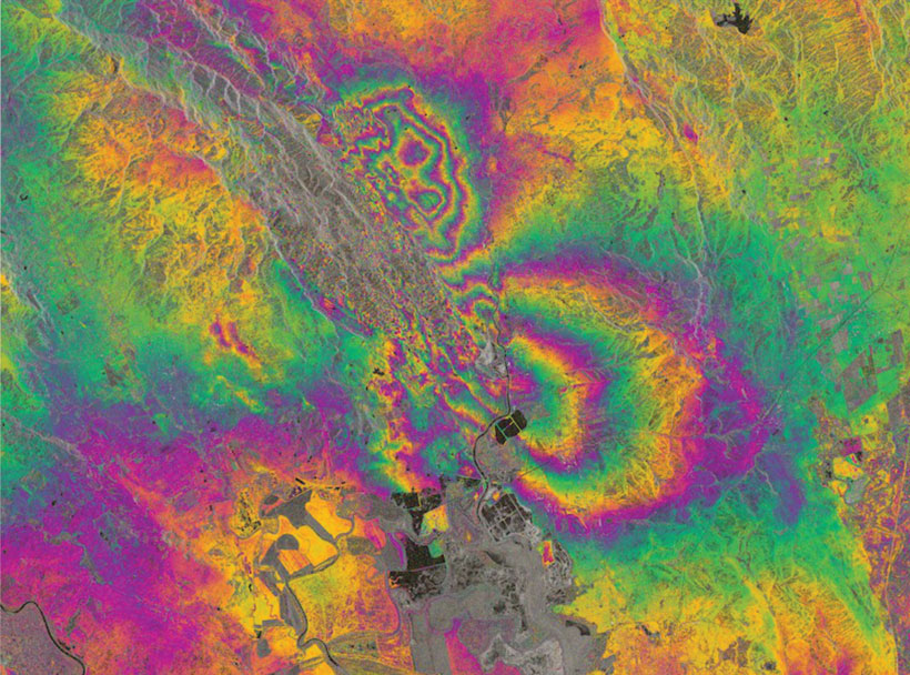
The earthquake slipped mainly along a previously partly mapped portion of the West Napa Fault zone, an area thought to store a small component of the potential seismic energy through this part of California [d’Alessio et al., 2005]. The first interferogram created by Sentinel-1A shows that the eastern side of the rupture moved about 10 centimeters in a southeastward direction, matching surface observations by scientists from the University of California, Davis, and the USGS.
Typically, ground motions in California follow strike-slip patterns, in which different regions of crust slide past each other along the fault. However, away from the fault trace, particularly near the ends of the rupture, significant vertical motion can also deform the ground.
Sentinel-1A reveals all this motion in great detail. The small surface displacements measured in the interferogram agree with the small offsets measured in the field by geologists surveying the fault rupture, who found displacements in roads and curb stones of about 10–20 centimeters (A. E. Morelan and C. Trexler, personal communication, 2014).
Documenting the Earthquake’s Ripple Effect in Space and Time

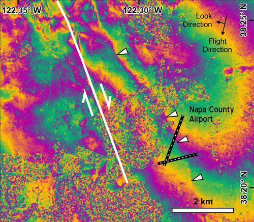
The interferogram also revealed other portions of the fault system that moved slightly in this event. Sharp lines in the interferogram, known as phase discontinuities, show minor movements on other faults, such as the part of the West Napa Fault zone that runs under Napa County Airport (Figure 2). This information, useful for illuminating other active parts of fault systems, can help direct future field investigation looking at fault activity.
On 12 September 2014, Sentinel-1A acquired a third image over the South Napa earthquake rupture. The sharp discontinuity in this interferogram (Figure 3) shows further slip of about 2 centimeters along the fault after the main quake, beautifully confirming other widespread field observations.

The rupture and afterslip were also captured by other satellites (Italy’s Constellation of Small Satellites for the Mediterranean Basin Observation (COSMO-SkyMed) and Canada’s Radarsat-2), as well as airborne radar systems (NASA’s Uninhabited Aerial Vehicle Synthetic Aperture Radar (UAVSAR), an instrument mounted to a modified business jet). Combining these various data sets offers scientists the chance to build up a relatively dense time series of the evolution of fault slip and aseismic creep, enabling them to better understand fault friction and behavior.
New SAR Acquisition Mode
The images that Sentinel-1 acquired over Napa Valley in August 2014 happened to be in “StripMap” mode, in which the satellite scans the ground in a single strip, generating one long image 80 kilometers wide. StripMap is similar to the default high-resolution mode used by most previous radar satellites. However, for Sentinel-1, the default radar acquisitions over continental areas will be in a novel mode, in which the craft steers its radar beam, taking three smaller and slightly overlapping images that will be stitched together into one wider image [Salvi et al., 2012].
The most significant advantage of this new scanning mode, called Terrain Observation by Progressive Scans (TOPS), is that a 250-kilometer-wide image can be acquired at high spatial resolution. This wider swath means that Sentinel-1A is the first radar satellite that can revisit any point on Earth’s land surface every 12 days.
On the other hand, TOPS introduces a new challenge: The wealth of individual images requires very different processing and data management methods than the old SAR acquisition types with a single image per product. An active research topic for the community of scientists involved with analyzing SAR/InSAR data involves developing strategies for optimally handling TOPS data. These strategies include creating new software processing tools for the radar and using large hardware servers to be able to store the anticipated huge volumes of data that will be collected over the 20-year lifetime of the program.
[pullquote float=”left”]Sentinel-1A’s wide swath makes it the first radar satellite that can revisit any point on Earth’s land surface every 12 days.[/pullquote]Open Data and Other Future Aspirations
The science team plans to be ready by mid-2015 to process the vast quantities of data that Sentinel-1A will collect. In 2016, Sentinel-1A will be joined by a second, identical satellite, Sentinel-1B, completing the constellation. The added satellite will double the amount of data collected and halve the revisit time to 6 days, improving the quality of data and capturing with greater ease rapidly changing events as they unfold. The mission will have a long duration to ensure data consistency and continuity, with future launches planned as each satellite fails or runs out of fuel to extend the time series to at least 20 years.
For the first time for any radar mission, Sentinel-1 data will be freely available to the whole community. Specifically, the UK Natural Environment Research Council’s Centre for the Observation and Modelling of Earthquakes, Volcanoes and Tectonics (COMET) plans to provide the research community with the processed InSAR results from Sentinel-1 for all the tectonic and volcanic regions of the planet. This data availability will greatly widen the group of users and scientists who will be able to exploit these previously restricted data sets.
When the Sentinel-1 constellation is fully operational, the average time delay between an earthquake and the first post-event acquisition will be just 1.5 days. The team will post interferograms and standard analyses of the InSAR data for earthquakes online in near-real time, providing robust information for scientists and responders in the field.
At the same time, the regular acquisitions of data will quickly build into large stacks for each track as the mission progresses. COMET will use these to produce estimates of average surface velocities and time-dependent motions. These estimates can help scientists assess the slow accumulation of interseismic strain around locked faults and also probe the fluid-like behavior deeper within the crust.
By 2034, there will be a 20-year archive of radar data from the Sentinel-1 program. We can expect that this archive will fundamentally change the way we view our planet, monitor surface processes, and analyze the evolution of geohazards over time.
Acknowledgments
We gratefully acknowledge the European Space Agency’s (ESA) Copernicus program and also funding from ESA’s Scientific Exploitation of Operational Missions (SEOM) program under contract 4000110680/14/I-BG. The interferograms presented are a derived work of Copernicus data, subject to the ESA use and distribution conditions.
References
Burgmann, R., P. A. Rosen, and E. J. Fielding (2000), Synthetic aperture radar interferometry to measure Earth’s surface topography and its deformation, Annu. Rev. Earth Planet. Sci., 28, 169–209, doi:10.1146/annurev.earth.28.1.169.
d’Alessio, M. A., I. A. Johanson, R. Bürgmann, D. A. Schmidt, and M. H. Murray (2005), Slicing up the San Francisco Bay Area: Block kinematics and fault slip rates from GPS-derived surface velocities, J. Geophys. Res., 110, B06403, doi:10.1029/2004JB003496.
Hooper, A., D. Bekaert, K. Spaans, and M. Arıkan (2012), Recent advances in SAR interferometry time series analysis for measuring crustal deformation, Tectonophysics, 1–13, doi:10.1016/j.tecto.2011.10.013.
Salvi, S., S. Stramondo, G. J. Funning, A. Ferretti, F. Sarti, and A. Mouratidis (2012), The Sentinel-1 mission for the improvement of the scientific understanding and the operational monitoring of the seismic cycle, Remote Sens. Environ., 120, 164–174.
Author Information
John R. Elliott, Centre for the Observation and Modelling of Earthquakes, Volcanoes and Tectonics (COMET), Natural Environment Research Council, UK; also at Department of Earth Sciences, University of Oxford, UK; Austin J. Elliott, Earth and Planetary Sciences, University of California, Davis; Andrew Hooper, COMET and School of Earth and Environment, University of Leeds, UK; Yngvar Larsen, Northern Research Institute, Tromsø, Norway; Petar Marinkovic, Laboratories for Processing Planetary Observations (PPO.Labs), The Hague, Netherlands; Tim J. Wright, COMET and School of Earth and Environment, University of Leeds, UK
Citation: Elliott, J. R., A. J. Elliott, A. Hooper, Y. Larsen, P. Marinkovic, and T. J. Wright (2015), Earthquake monitoring gets boost from new satellite, Eos, 96, doi:10.1029/2015EO023967. Published on 12 February 2015.
Text © 2015. The authors. CC BY 3.0
Except where otherwise noted, images are subject to copyright. Any reuse without express permission from the copyright owner is prohibited.

