From 1926 to 1928, William Herbert Hobbs, a professor at the University of Michigan, led a series of three annual scientific expeditions to Greenland. Hobbs and his colleagues on these missions collected some of the earliest geophysical and atmospheric measurements in this region, including the first documentation of gravity-driven katabatic winds, which carry cool, dense air masses down solid slopes like ice sheets or hillsides and which earned Greenland the title of “north pole of the winds.”
Almost a century later, in June 2019, four faculty members (including P.S., M.F., and J.B.) led a team of undergraduate students (including C.S., L.G., and A.M.) from the University of Michigan, the University at Albany in New York, the Virginia Polytechnic Institute and State University, and the University of Monterrey in Mexico on a 10-day field expedition to Greenland to repeat some of Hobbs’s original work. The trip provided the students with field experience and practice in collecting measurements relevant to the meteorology and climate of Greenland.
The 2019 expedition was also focused on introducing a diverse cohort of young researchers to polar science and on exploring the effects of climate change experienced by Greenlandic residents. Hobbs’s expedition teams were all male; glaciology did not include women in those days. In contrast, the 13 students in the 2019 group represented different genders, ages, socioeconomic backgrounds, educations, and international experiences. Of this group, seven students identified as female, and one student identified as nonbinary. Although we came from diverse backgrounds, we were united in our passion for studying climate change and the environment.
An Arctic Adventure Begins
The journey began in Albany, N.Y., where we spent 3 days completing instrumentation training and logistical planning and getting to know the people with whom we would be sharing this unique experience. During this time, the faculty leaders introduced important environmental concepts that would be important for the trip. With this information, it was the students’ task to create a plan for when we were in the field and detail what types of measurements we wanted to take and where.
For many of us, this would mark the first time we voyaged into the Arctic Circle, embarked on an international trip, or, for one student, even caught a first glimpse of snow.
After this initial training and with all the equipment packed, we made our way to Stratton Air National Guard Base in nearby Schenectady, N.Y., where we boarded a C-130 military transport plane and departed for Kangerlussuaq Airport in western Greenland.
We were undeniably excited, but we were also nervous about the journey. For many of us, this would mark the first time we voyaged into the Arctic Circle, embarked on an international trip, or, for one student, even caught a glimpse of snow. This same feeling resonated with the professors, who were concerned about the safety and well-being of the participants.
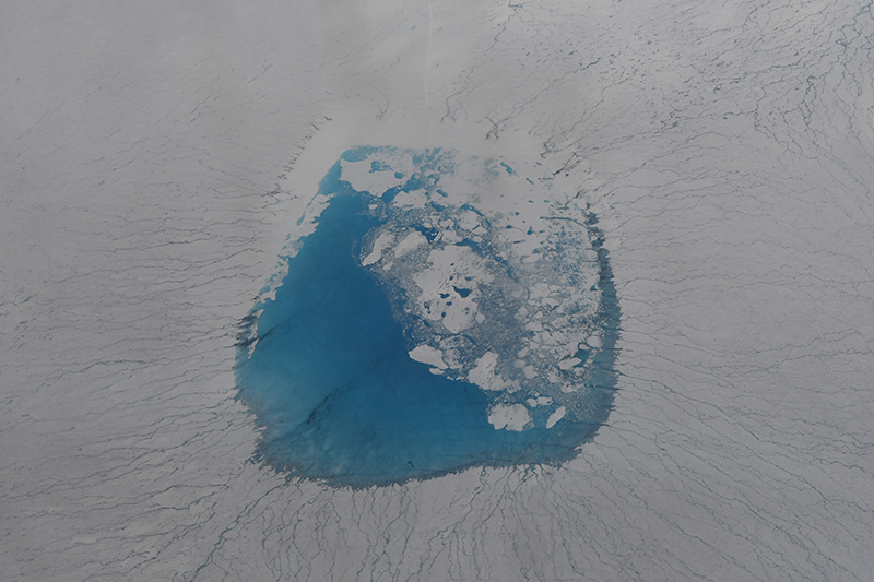
Window real estate on the plane was limited, and the aircraft was crowded with various research groups, making it difficult to move about in the space. The cramped flight was worth it, though, when we saw our first glimpse of Greenland, the icy Arctic landscape painted in various shades of blue. We also saw large melt lakes that served as a reminder of the extreme melt season underway. It was at this moment that our group could truly visualize the devastating impacts of climate change on this landscape.
After arriving at Kangerlussuaq, we had only 10 days to fulfill the objectives of our expedition, so our day-to-day schedule was busy. We learned quickly that pursuing field experiments requires flexibility, especially with large groups. In a couple of instances, we changed plans because of the weather, and at other times we adjusted our schedule to attend presentations given by the local community.
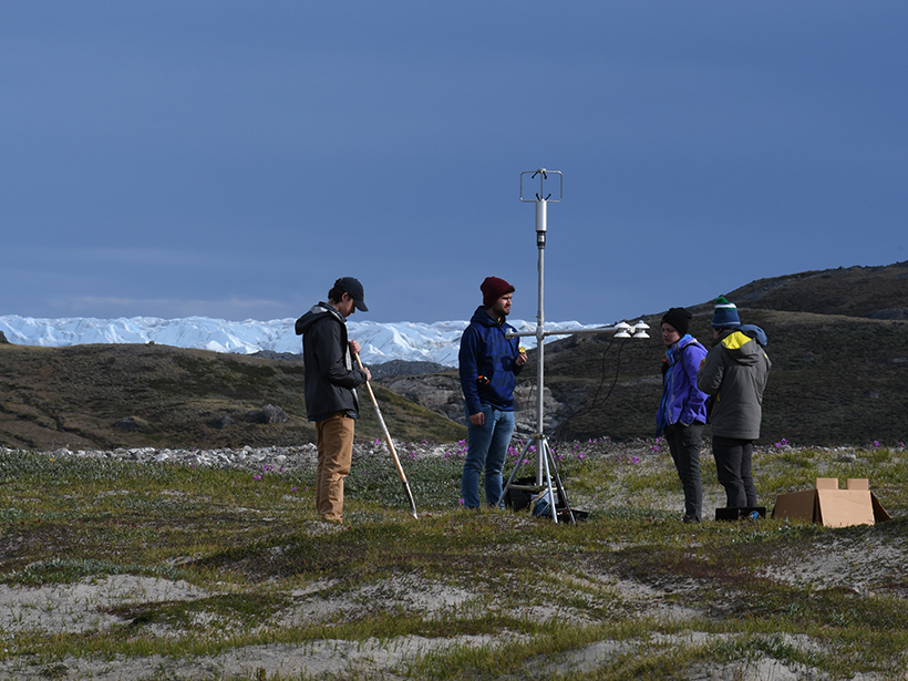
We spent much of our time setting up field experiments that we would later conduct on and around the Greenland Ice Sheet. For example, we took the opportunity to launch a weather balloon close to our camp to capture data about wind circulation along the ice sheet.
The face of the ice sheet was visible from the top of Black Ridge, located near the Kangerlussuaq International Science Support (KISS) building, our base of operations, but we couldn’t fully appreciate the vastness of the ice until we trekked up a portion of Russell Glacier.
The ice-covered landscape was surrounded by sandy glacial deposits, home to a myriad of minerals, including garnet gems. Instead of the crisp, white snow typically depicted in museum paintings of snowcapped mountains or icy landscapes, we saw a glacier covered in dark layers of earth dug up as the ice moved. This image would become familiar after multiple hikes back to the glacier’s towering calving front.
Listening to the Glacier
The remoteness of the region and the lack of sound pollution allowed us to listen to the acoustic crackling deep within the glaciers.
When we first arrived at the calving front on an overnight field excursion, it was apparent that fragments of the glacier had fallen into the river below. The remoteness of the region and the lack of sound pollution allowed us to listen to the acoustic crackling deep within the glaciers. We wondered if more ice would soon break free, so we set up a camera overnight, hoping to record what we suspected would be a large calving event on one section of the ice.
We mounted the camera between two small rocks to protect it from strong wind gusts and looked forward to returning the next day. When we returned, it was obvious that part of the glacier face had indeed calved, but the camera had stopped recording after a few hours and missed the event. Fortunately, the river flow instrument we had also left at the site caught the change in water height when the calving event occurred. Seeing firsthand how quickly changes to the glacier face could occur reiterated how fast these seemingly permanent structures can break apart and disappear.

After our return from the overnight expedition near Russell Glacier, we flew on a C-130 to Summit Station at the center of the Greenland Ice Sheet. Although our visit to the research station lasted only an hour, it significantly affected us all. The endless expanse of ice and drifting snow seemed to belong to a world other than the one in Kangerlussuaq.
At Summit Station, we saw a grid of poles—set up by researchers conducting snow accumulation experiments to prevent confusion in whiteout conditions—marking paths to different locations. In the Big House, the main structure of Summit Station, we learned about living and working conditions at the station, including the fact that during winter, typically, only a few people are in residence and food supplies can run short. Despite the difficult circumstances there, several of us left inspired to one day return to pursue research at Summit Station.
Learning by Doing
An important aspect of the expedition was for the undergraduate students to learn necessary skills for designing and executing successful research projects. During the campaign, our team measured surface energy flux and stream flow on and around the Greenland Ice Sheet, and we collected upper air radiosonde data on pressure, temperature, dew point, and wind speed and direction. The students used drones to learn about remote sensing practices, and we collected topographic data to create a 3-D map of Russell Glacier that will help in monitoring ice loss in our changing climate.
A lasting outcome of the trip was our installation of an air quality sensor that captured elevated particulate matter levels during the Greenland fires that broke out 2 weeks after our expedition.
A lasting outcome of the trip was our installation of an air quality sensor, attached to the Danish meteorological station outside Kangerlussuaq, for real-time monitoring using the PurpleAir network. The sensor captured elevated particulate matter levels during the Greenland fires that broke out 2 weeks after our expedition.
This effort is the start of obtaining a long-term data set of aerosol particulate concentrations in this remote location—data that will be used to monitor how aerosols are transported to Greenland and their associated impacts on air quality and ice melting.
To commemorate the original Hobbs expeditions and contrast techniques of old and modern remote sensing capabilities, we also launched several pilot balloons similar to the ones used on Hobbs’s expedition and tracked their trajectories with a theodolite (a telescope-like surveying tool used to measure horizontal and vertical angles).

A Lasting Impact
Events in Greenland (which is served by only two commercial airlines) remain largely unnoticed by the rest of the world. But the reality of climate change and its effects on this remote land became particularly apparent through our conversations with local community members. Many of those we spoke to remarked, for example, about a recent increase in polar bear sightings in the Kangerlussuaq region, attributed to the bears roaming south in search of food.
Research experiences in remote environments inspire students and allow them to explore a wide range of interests while learning how to create cohesive research plans and work through obstacles that arise in the field.
The Greenland expedition left a significant impression on the students. As the trip concluded, they reflected on their experiences and what the trip meant to them. Several reported that the experience sparked their interest in pursuing research about the environment or about climate science in graduate school. And after the expedition, the student participants remained engaged through analysis of the data collected during the trip and through advocating for climate justice and diversity in science, technology, engineering, and mathematics.
Involving undergraduate students in experiential learning introduces them to new skills and interests and is essential for academic and professional development. Research experiences in remote environments inspire students and allow them to explore a wide range of interests while learning how to create cohesive research plans and work through obstacles that arise in the field. This expedition enabled students to explore different fields related to polar science in a dynamic environment.
Leading a trip like this one is not an easy task. It requires extensive planning and organization, but it offers an important—and potentially career altering—learning experience for participants.
Author Information
Chelsea E. Snide ([email protected]), Lydia Gilbert, Abigail Meyer, Perry Samson, Mark Flanner, and Jeremy Bassis, University of Michigan, Ann Arbor
Citation:
Snide, C. E.,Gilbert, L.,Meyer, A.,Samson, P.,Flanner, M., and Bassis, J. (2020), Seeing the Greenland Ice Sheet through students’ eyes, Eos, 101, https://doi.org/10.1029/2020EO139739. Published on 04 February 2020.
Text © 2020. The authors. CC BY-NC-ND 3.0
Except where otherwise noted, images are subject to copyright. Any reuse without express permission from the copyright owner is prohibited.