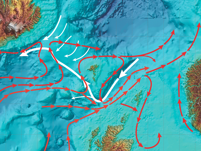
Warm, salty water from the northeastern Atlantic Ocean enters the Nordic seas through the passages between Iceland, the Faroe Islands, and Scotland. These waters continue north along the eastern margin of the Nordic seas, where they gradually cool, sink to progressively greater depths, and fill all basins with dense water. This water eventually flows back into the deep North Atlantic, compensating for the water transport and associated heat flux to high latitudes that help maintain the mild climate of central and northern Europe.
A strength of the workshop was the review and discussion of sustained observations, novel techniques, and modeling activities.
This flow of warm water north and the return of cold water at depth have been a major focus of many institutional and international initiatives over the years. In January 2017, the Faroe Marine Research Institute (FAMRI) hosted a workshop to bring these activities into clearer focus and to identify issues of concern.
A strength of the workshop was the review and discussion of sustained observations, novel techniques, and modeling activities. Sustained observation includes hydrography, which began with the seminal study by Helland-Hansen and Nansen in 1909 and continues today with quarterly hydrographic surveys by FAMRI and Marine Scotland Science. Participants agreed that these surveys have played a major role in tracking interannual and decadal changes in water properties and long-term variations in transport.

In addition, since 1994, numerous deployments of ocean current meters and acoustic Doppler current profilers on moored platforms have given researchers a far better understanding of the variability of currents at selected sites over a wide range of timescales. The high-seas ferry M/S Norröna now also observes ocean currents and water properties underway at high horizontal resolution on her passage across the North Sea, the Faroe-Shetland Channel (FSC), and the Iceland-Faroe Ridge (IFR).
Remote sensing of sea surface height complements the above hydrographic and moored and underway approaches by providing a valuable space-time context of the upper ocean, workshop attendees agreed. Roughly half of all water entering the Nordic seas spills back into the North Atlantic through the Faroe Bank Channel and across the IFR. Of great interest to participants was how these waters flow across and slide down the ridge’s slopes, mix with surrounding waters, and eventually equilibrate. They noted that this flow needs to be understood to properly parameterize large-scale general circulation models.
Major topics to emerge at the workshop included the following:
- the recognition of large temporal variations in Atlantic inflows toward the Nordic seas, much, but not all, of which is wind driven
- the surprisingly large variations in the southward flow on the western side of the FSC, the causes of which are not yet fully understood
- the challenge of reconciling estimates of Nordic seas exchange rates from diverse observational approaches
- processes with shorter timescales (less than 2 weeks) and smaller spatial scales (5–10 kilometers) and their impact on the larger-scale flow patterns
Participants formed several subgroups to explore how the different observational methods can be best used to support and complement each other. Each subgroup will report its findings for continued discussion and development at a planned follow-up meeting in Bergen, Norway, in September 2017. Interested parties are welcome to join.
A comprehensive report of workshop discussions can be found on the FAMRI website.
Acknowledgments
Participants are grateful to the various funding agencies that have ensured sustained observations in the FSC and IFR and supported related research projects. In particular, the attendees acknowledge the financial support of the following organizations and projects: the Norröna project (U.S. National Science Foundation and Smyril Line); the European Commission through the North Atlantic Climate (NACLIM) program (FP7, G.A. number 308299), AtlantOS (H2020, G.A. number 633211), and Blue-Action (H2020, G.A. number 727852); the Scottish government; the Danish government through Dancea projects Western Valley Overflow (WOW; 2016–2018) and Faroese Monitoring (FARMON; 2017–2019); and the Bjerknes Center for Climate Research, Research Group 4 for travel funding.
—Barbara Berx (email: [email protected]), Marine Scotland Science, Aberdeen, UK; Karin Margretha H. Larsen, Faroe Marine Research Institute, Tórshavn, Faroe Islands; and T. Rossby, Graduate School of Oceanography, University of Rhode Island, Kingston
Citation:
Berx, B.,Larsen, K. M. H., and Rossby, T. (2017), Tracking water through the North Atlantic Ocean, Eos, 98, https://doi.org/10.1029/2017EO076827. Published on 19 July 2017.
Text © 2017. The authors. CC BY-NC-ND 3.0
Except where otherwise noted, images are subject to copyright. Any reuse without express permission from the copyright owner is prohibited.