
Remote sensing measurements for water vapor isotopic composition enable us to assess how convective aggregation influences the atmospheric hydrological cycle.
AGU Advances

Posted inResearch Spotlights
Better Bottom-Up Estimates of Wetland Methane Emissions
Limited monitoring of methane emissions from tropical wetlands could be obscuring these environments’ role in climate change.

Posted inEditors' Highlights
Northern Ecosystems are Shaped by Snow
Changing climate in the Arctic leads to a shorter snow season but deeper snow in the depths of winter. Under the insulating snow, biological processes are accelerated leading to higher nutrient availability and carbon losses.

Posted inEditors' Highlights
Pliocene Conveyer Belt in the Pacific
Ocean Drilling Program cores and helium isotopes put better constraints on the ocean circulation in the north Pacific.

Posted inEditors' Highlights
Low-Frequency Quakes Have Modest Effect on Slow Earthquake Cycle
Slow slip phenomena on subdaily scales, captured by seismic and GNSS data, show that low-frequency earthquakes are incidental to larger magnitude slow earthquakes, in which aseismic slip dominates.

Posted inEditors' Highlights
Barnacles Help Reconstruct Drift Path of Malaysia Airlines Flight MH370
Careful calibration of isotopes in a barnacle shell growing on ocean debris – in this case an airplane part – informs a new forensic method to identify its most probable drift path.
Posted inEditors' Highlights
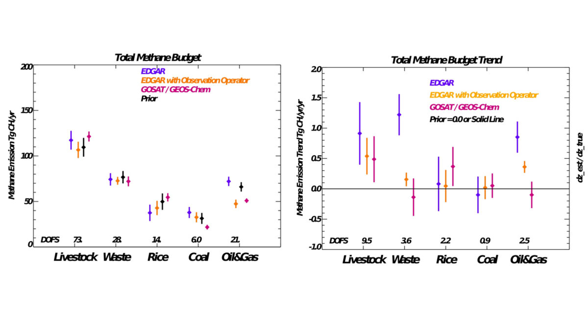
Using Bayesian Estimation to Improve Methane Inventories
A Bayesian, optimal estimation evaluation of state-of-the-art methane inventory with satellite-based emissions from 2009 to 2018 finds substantial differences for livestock, rice, and coal emissions.
Posted inEditors' Highlights
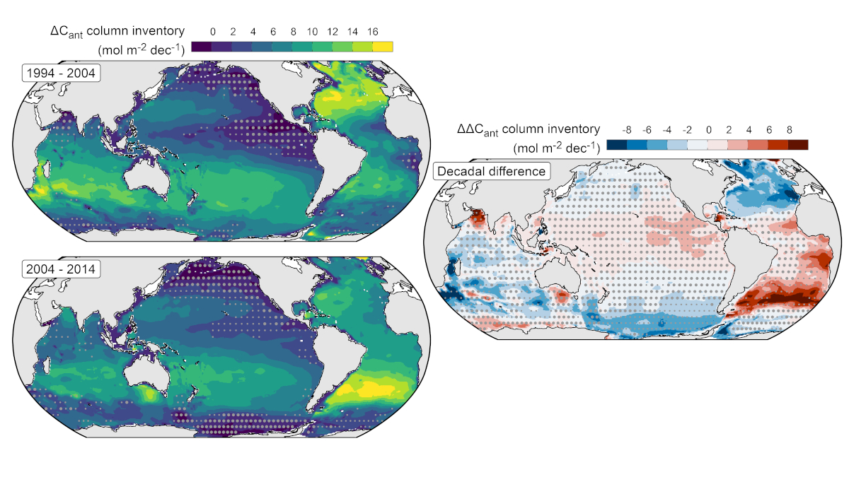
A Multidecadal View of Oceanic Storage of Anthropogenic Carbon
A decline in the ratio of ocean carbon accumulation to atmospheric carbon dioxide growth between 1994-2004 and 2004-2014 suggests a reduction in the sensitivity of the ocean carbon sink.

Posted inEditors' Vox
The Art of Promoting Scientific Results
AGU has various avenues for promoting noteworthy research published in our journals and books, which increases visibility, downloads, and citations.
Posted inEditors' Highlights
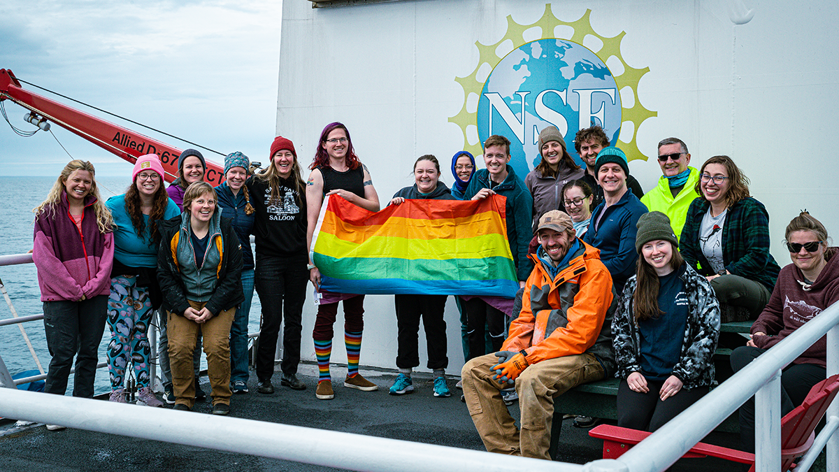
Fair Seas for All
Work at sea is key to our science, but, too often, transgender and gender-diverse scientists face obstacles and harassment that make field research a trial. A few simple steps can make things more inclusive.