• About
  • Sections
  • Topics
    • Climate
    • Earth Science
    • Oceans
    • Space & Planets
    • Health & Ecosystems
    • Culture & Policy
    • Education & Careers
    • Opinions
  • Projects
    • ENGAGE
    • Editors’ Highlights
    • Editors’ Vox
    • Eos en Español
    • Eos 简体中文版
    • Print Archive
  • Blogs
    • Research & Developments
    • The Landslide Blog
  • Newsletter
  • Submit to Eos
  • AGU.org
  • Career Center
  • Join AGU
  • Give to AGU
  • About
  • Sections
  • Topics
    • Climate
    • Earth Science
    • Oceans
    • Space & Planets
    • Health & Ecosystems
    • Culture & Policy
    • Education & Careers
    • Opinions
  • Projects
    • ENGAGE
    • Editors’ Highlights
    • Editors’ Vox
    • Eos en Español
    • Eos 简体中文版
    • Print Archive
  • Blogs
    • Research & Developments
    • The Landslide Blog
  • Newsletter
  • Submit to Eos
Skip to content
  • AGU.org
  • Career Center
  • Join AGU
  • Give to AGU
Eos

Eos

Science News by AGU

Support Eos
Sign Up for Newsletter
  • About
  • Sections
  • Topics
    • Climate
    • Earth Science
    • Oceans
    • Space & Planets
    • Health & Ecosystems
    • Culture & Policy
    • Education & Careers
    • Opinions
  • Projects
    • ENGAGE
    • Editors’ Highlights
    • Editors’ Vox
    • Eos en Español
    • Eos 简体中文版
    • Print Archive
  • Blogs
    • Research & Developments
    • The Landslide Blog
  • Newsletter
  • Submit to Eos

air pollution

Illustration of MAIA instrument’s multiangle views over the globe
Posted inNews

Using Satellite Data to Map Air Pollution and Improve Health

by Jackie Rocheleau 15 April 20211 November 2021

NASA scientists will be teaming up with epidemiologists in the agency’s first health-focused mission. With satellite data, they’ll find out how air pollution affects health in cities around the world.

Map of the Melbourne region showing how radio link observations correlated with measurements from surface air quality stations
Posted inEditors' Highlights

New Data on Smoke Particulates from Cellular Radio Signals

by D. Wuebbles 25 March 202126 October 2021

Through analyzing radio links signal levels, retrieved surface smoke particulate concentrations can complement limited datasets from air quality stations in improving impacts analyses for wildfires.

Satellite image of Hurricane Harvey swirling over the Texas coast
Posted inNews

To Make Better Hurricane Models, Consider Air Pollution

Rachel Fritts, Science Writer by Rachel Fritts 23 December 20203 November 2022

New research uses Hurricane Harvey as a case study to demonstrate the devastating power of aerosols to supercharge tropical storms.

Plot showing average temperature change over California caused by reductions in airborne particle concentrations
Posted inEditors' Highlights

Comparing Impacts of CO2 and Particle Emission Reductions

by Lynn Russell 11 November 202014 February 2023

Black carbon contained in airborne particles is often cited as a major factor warming the climate, but how much can California reduce climate change through reducing airborne particle concentrations?

Commercial passenger plane flying
Posted inFeatures

Greening the Friendly Skies

Mark Betancourt, Freelance Journalist by Mark Betancourt 4 November 202022 January 2024

Decarbonizing the aviation industry won’t be easy. The coronavirus pandemic complicates the situation but also presents an opportunity.

Satellite image of the Himalayas
Posted inNews

Pollution over the Tibetan Plateau Linked to Sea Ice Loss in the Arctic

by Michael Allen 7 October 202028 February 2023

New research suggests an atmospheric connection between Arctic sea ice melt and anthropogenic aerosol pollution over the Tibetan Plateau.

Lightning strike from a thunderstorm
Posted inNews

Decrease in Lightning Recorded over the Lower 48

Katherine Kornei, Science Writer by Katherine Kornei 21 September 20209 September 2022

Researchers mining data from the National Lightning Detection Network found a 32% decrease in lightning counts in May and June 2020 compared with previous years.

People stand in a scrapyard as dark smokes billows from several small fires.
Posted inResearch Spotlights
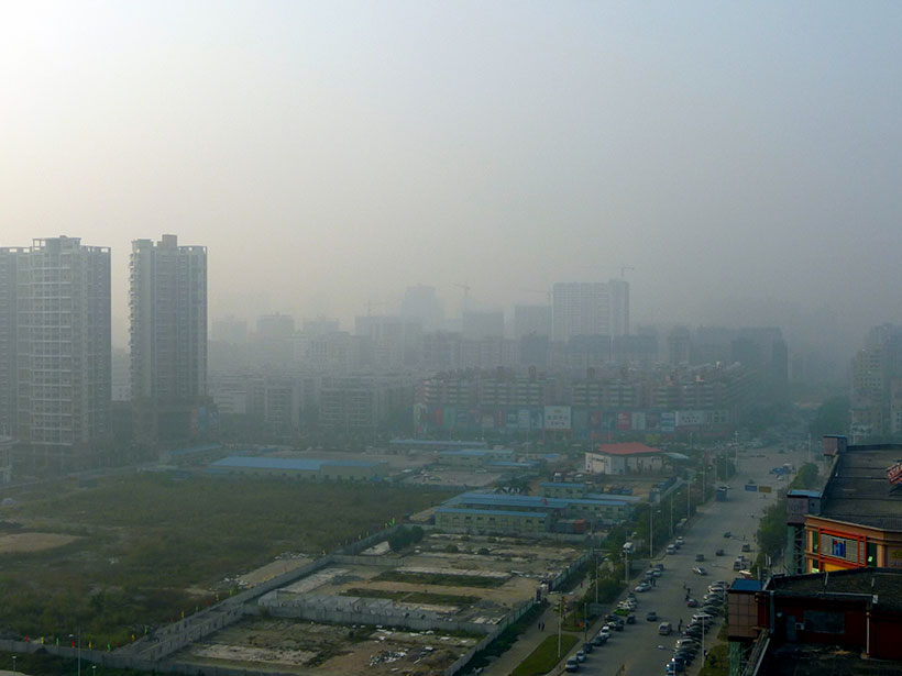
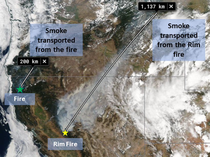
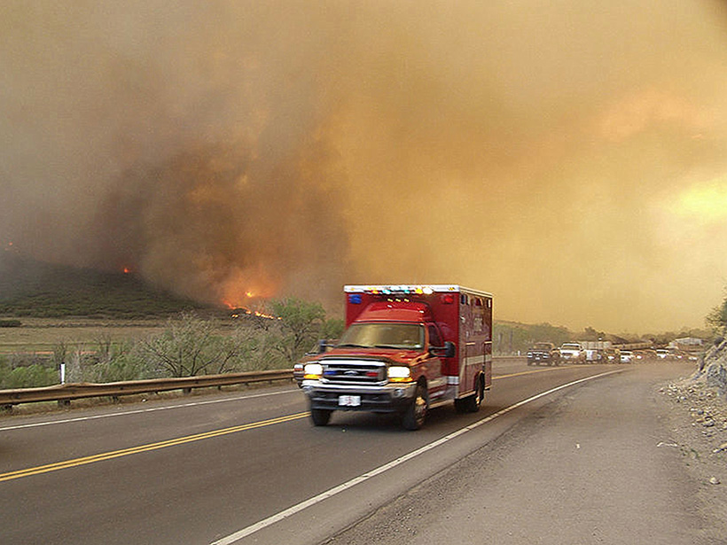
Tracking Air Pollution from Ghana’s E-Waste Site

Kate Wheeling, freelance science writer by Kate Wheeling 18 August 202013 March 2023

Researchers established a relatively low cost method that could help countries with limited monitoring capabilities measure particulate pollution in their skies.

Gold dome of Shwedagon Pagoda dominates the skyline
Posted inNews

A Golden Opportunity to Save Shwedagon Pagoda’s Acclaimed Dome

Richard Sima, freelance science writer by Richard J. Sima 10 July 20206 January 2023

The dome is replaced every 5 years, and researchers are studying how to make the gold more durable.

Skewered meat and vegetables on a barbecue
Posted inNews

Niveles Altos de Contaminación en Chile se Relacionan Con Parrilladas de Hinchas del Fútbol

Katherine Kornei, Science Writer by Katherine Kornei 8 July 202030 November 2022

Misteriosos picos de contaminación—10 veces más altos que los niveles normales—ocurren en Santiago durante los partidos de fútbol televisados y son causados por decenas de miles de parrilladas, revelan nuevos resultados.

Posts pagination

Newer posts 1 … 10 11 12 13 14 … 17 Older posts
A view of a Washington, D.C., skyline from the Potomac River at night. The Lincoln Memorial (at left) and the Washington Monument (at right) are lit against a purple sky. Over the water of the Potomac appear the text “#AGU24 coverage from Eos.”

Features from AGU Publications

Research Spotlights

Arctic Rivers Trade Inorganic Nitrogen for Organic

6 August 20256 August 2025
Editors' Highlights

Nearly 94 Million Boulders Mapped on the Moon Using Deep Learning

6 August 20255 August 2025
Editors' Vox

Early-Career Book Publishing: Growing Roots as Scholars

6 August 202530 July 2025
Eos logo at left; AGU logo at right

About Eos
ENGAGE
Awards
Contact

Advertise
Submit
Career Center
Sitemap

© 2025 American Geophysical Union. All rights reserved Powered by Newspack