
Seismic signals detected hundreds of kilometers away from Greenland glaciers reveal the calving style and iceberg size.
Journal of Geophysical Research: Earth Surface

Posted inNews
The Permafrost Listeners
Geophysicists have discovered a way to monitor permafrost thaw by measuring seismic waves so gentle they don’t shake a thing.
Posted inEditors' Highlights
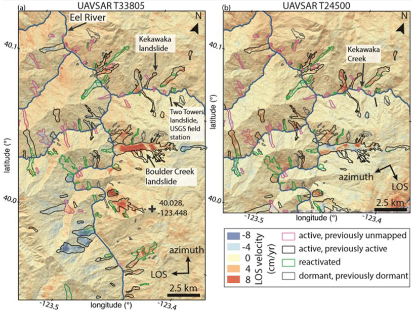
Landslide Activity Ramps Up With Extreme Rainfall
An increase in activity of hundreds of slow-moving landslides during extreme wet conditions in California provides insights into the landscape response to ongoing climate change.
Posted inResearch Spotlights
Arctic Glacial Retreat Alters Downstream Fjord Currents
High-resolution mapping efforts could improve predictions of coastal changes as glaciers shrink around the world.

Posted inResearch Spotlights
Missing Lakes Under Antarctic Ice Sheets
New radio sounding study finds little evidence of lakes under Antarctica’s Recovery Glacier.

Posted inEditors' Highlights
Enabling Dynamic, Regional-Scale Modelling of Outburst Floods
The GeoClaw model is used to simulate a landslide-dam outburst flood through rugged Himalayan topography.

Posted inResearch Spotlights
Study of Alaskan Landslide Could Improve Tsunami Modeling
A rare submarine landslide provides researchers with a reference point for modeling the biggest tsunamis.

Posted inResearch Spotlights
Subglacial Water Can Accelerate East Antarctic Glacier Flow
Airborne radar from the Recovery Glacier system demonstrates the importance of characterizing the underlying causes of ice flow speedup to understand how glacial discharge could change in the future.

Posted inEditors' Highlights
Formation of Sedimentary Deposits: Bypass Versus Mass Extraction
Grain size and sediment delivery pathways from the Ganges delta have been used to model downstream facies changes.
Posted inResearch Spotlights
A Novel Way to Map Debris Thickness on Himalayan Glaciers
By combining changes in elevation with other data, scientists have developed a method for estimating the thickness of debris covering glaciers on whose water more than 800 million people depend.