• About
  • Special Reports
  • Topics
    • Climate
    • Earth Science
    • Oceans
    • Space & Planets
    • Health & Ecosystems
    • Culture & Policy
    • Education & Careers
    • Opinions
  • Projects
    • Postcards From the Field
    • ENGAGE
    • Editors’ Highlights
    • Editors’ Vox
    • Eos en Español
    • Eos 简体中文版
    • Print Archive: 2015–2025
  • Policy Tracker
  • Blogs
    • Research & Developments
    • The Landslide Blog
  • Newsletter
  • Submit to Eos
  • AGU.org
  • Career Center
  • Join AGU
  • Give to AGU
  • About
  • Special Reports
  • Topics
    • Climate
    • Earth Science
    • Oceans
    • Space & Planets
    • Health & Ecosystems
    • Culture & Policy
    • Education & Careers
    • Opinions
  • Projects
    • Postcards From the Field
    • ENGAGE
    • Editors’ Highlights
    • Editors’ Vox
    • Eos en Español
    • Eos 简体中文版
    • Print Archive: 2015–2025
  • Policy Tracker
  • Blogs
    • Research & Developments
    • The Landslide Blog
  • Newsletter
  • Submit to Eos
Skip to content
  • AGU.org
  • Career Center
  • Join AGU
  • Give to AGU
Eos

Eos

Science News by AGU

Support Eos
Sign Up for Newsletter
  • About
  • Special Reports
  • Topics
    • Climate
    • Earth Science
    • Oceans
    • Space & Planets
    • Health & Ecosystems
    • Culture & Policy
    • Education & Careers
    • Opinions
  • Projects
    • Postcards From the Field
    • ENGAGE
    • Editors’ Highlights
    • Editors’ Vox
    • Eos en Español
    • Eos 简体中文版
    • Print Archive: 2015–2025
  • Policy Tracker
  • Blogs
    • Research & Developments
    • The Landslide Blog
  • Newsletter
  • Submit to Eos

tomography

A photo taken from on a hill shows a populated valley surrounded by brown mountains on a cloudy day.
Posted inNews

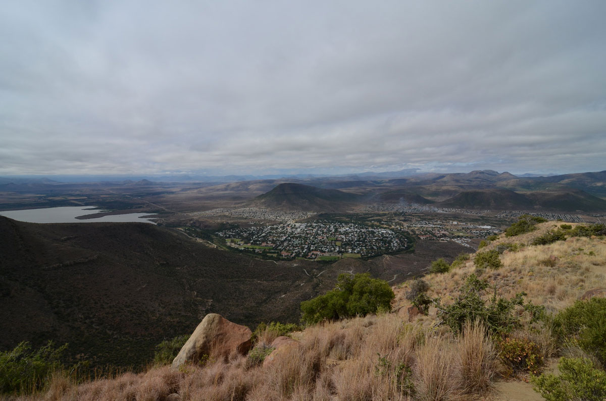
A Swarm of Earthquakes in South Africa’s Karoo Basin Poses Questions for Oil and Gas Development

by Ray Mwareya 20 May 202620 May 2026

A recent study cautions that the Karoo, a potential target for shale gas exploration, might not be as seismologically calm as it appears.

Italy’s Larderello region
Posted inNews

Scientists Find Thousands of Cubic Kilometers of Magma Hiding Beneath Tuscany

by Nathaniel Scharping 18 May 202618 May 2026

We already know what’s Under the Tuscan Sun. Now, a technique called ambient noise tomography has allowed researchers to see deep under the Tuscan crust.

Researchers stand in the distance as an orange electrical cord snakes across a dry lake bed in the Great Salt Lake.
Posted inNews

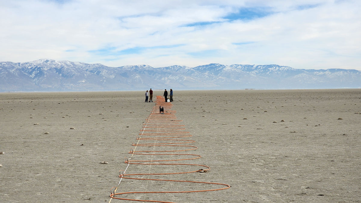
What’s Below the Great Salt Lake? More Water

by Carolyn Wilke 21 April 20261 June 2026

Pools of fresh water and salt water not far below the lake bed help explain some of the lake’s curious features, including mineral mounds and reed islands.

Italy’s Mount Etna, snowcapped and beneath a sky of puffy white clouds.
Posted inResearch Spotlights

Improved Imaging Offers New Insight into Mount Etna

by Rebecca Owen 9 July 20249 July 2024

Anisotropic tomography provides a more complete picture of the Sicilian volcano’s inner workings.

Map of the Hawaiian islands with colors and contour lines overlain.
Posted inEditors' Highlights

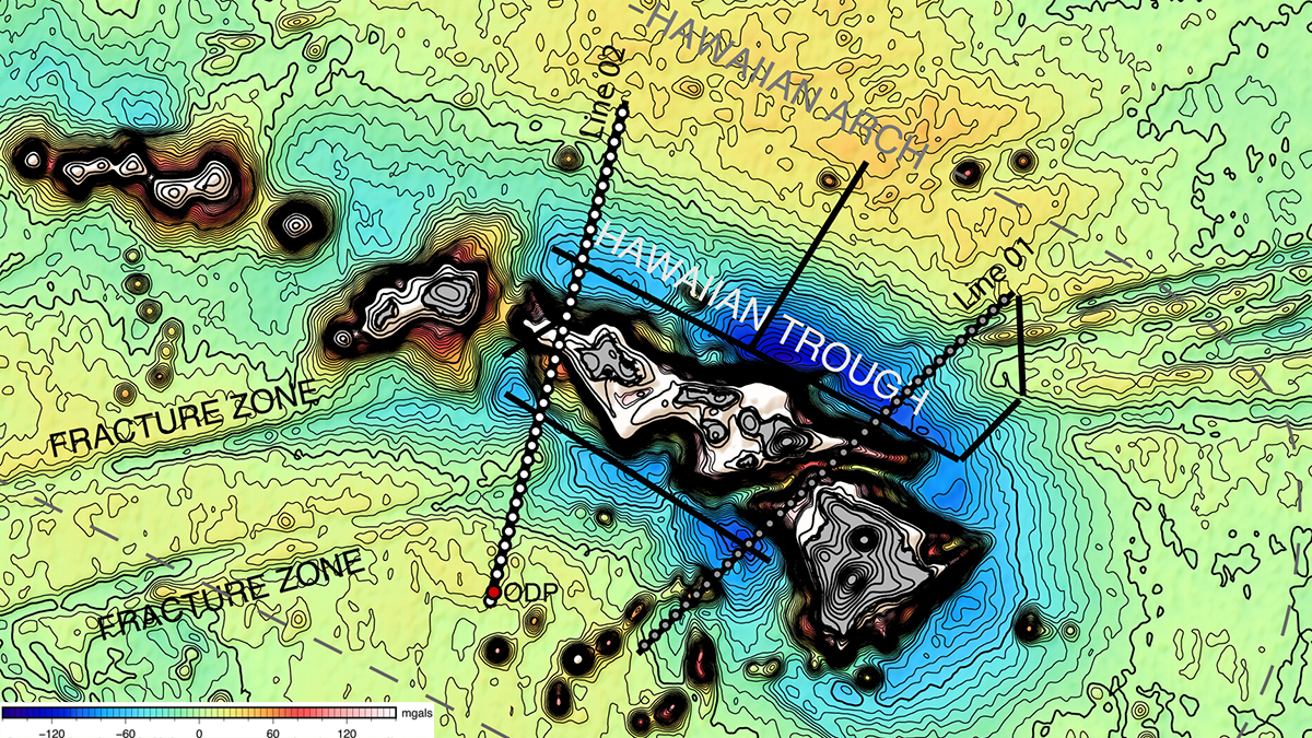
A Strong Pacific Plate Bends Under the Hawaiian Volcanic Chain

by Emilie Hooft 14 March 202413 March 2024

Two seismic studies reveal the volcanic loads and resulting flexure of the Pacific plate at the Hawaiian Ridge and, surprisingly, show no magmatic underplating.

Diagram from the paper.
Posted inEditors' Highlights

Rift-to-Ridge: Mid-Atlantic Ridge Segments Imprinted During Rifting

by Emilie Hooft 19 October 202317 October 2023

A new seismic study shows that magmatism along the eastern North American rift margin was segmented, and that rift discontinuities influence formation of fracture zones along the Mid-Atlantic Ridge.

Two maps showing locations of seismic arrays.
Posted inEditors' Highlights

Can Anelastic Attenuation of Oceanic Mantle be Reliably Measured?

by Fan-Chi Lin 26 October 20224 August 2023

A new study demonstrates that robust anelastic attenuation measurements can be made across ocean bottom seismic arrays at different locations using surface wave array analysis.

A map and 3 graphs showing the waveform fits for an earthquake.
Posted inEditors' Highlights

Western US Adjoint Tomography Reproduces Waveform Complexity

by Michael Bostock 22 July 202222 December 2022

Adjoint tomography employing 3D wavefield simulations for 72 well recorded regional earthquakes in the western U.S. yields spectacular improvements to waveform fits.

Three-dimensional shear wave velocity maps.
Posted inEditors' Highlights

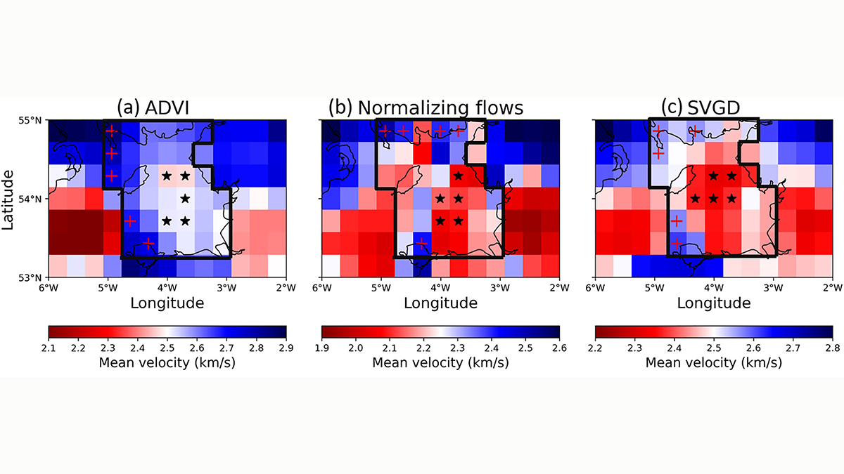
Probabilistic Tomography Delivers Answers to Basic Questions

by Michael Bostock 13 May 202227 January 2023

Fundamental questions on subsurface properties are robustly addressed through probabilistic assessment of multiple forward/inverse modelling formalisms using interrogation theory.

Perspective plot looking west across the Hikurangi margin (New Zealand) at the 3 km/s S-velocity isosurface contoured in depth.
Posted inEditors' Highlights

Adjoint Tomography Illuminates Hikurangi Margin Complexity

by Michael Bostock 21 April 202227 January 2023

Waveform inversion of regional earthquakes reveals velocity anomalies interpreted as subducting seamounts that control an enigmatic segmentation in plate coupling along the Hikurangi margin.

Posts pagination

1 2 3 Older posts
Over a dark blue-green square appear the words Special Report: The State of the Science 1 Year On.

Features from AGU Publications

Research Spotlights

As Wildfires Increase in the West, So Does Suppression Spending

10 June 202610 June 2026
Editors' Highlights

Multi-Scale Fault Roughness Encapsulated in a Friction Law

11 June 202611 June 2026
Editors' Vox

Small-Scale Indian Ocean Dynamics Underpin Marine Ecology and Climate

4 June 20263 June 2026
Eos logo at left; AGU logo at right

About Eos
ENGAGE
Awards
Contact

Advertise
Submit
Career Center
Sitemap

© 2026 American Geophysical Union. All rights reserved Powered by Newspack