
The Landslide Blog is written by Dave Petley, who is widely recognized as a world leader in the study and management of landslides.

In a paper just published in the journal Natural Hazards and Earth System Sciences, Chang et al. (2025) describe the 16 October 2022 Cilan Landslide in Taiwan. The research is fascinating, using seismic data nalaysis to understand the mechanics of a large failure traiggered by heavy rainfall associated with Typhoon Nesat, which brought 1,000 mm over a three day period, including a peak intensity of 103 mm per hour.
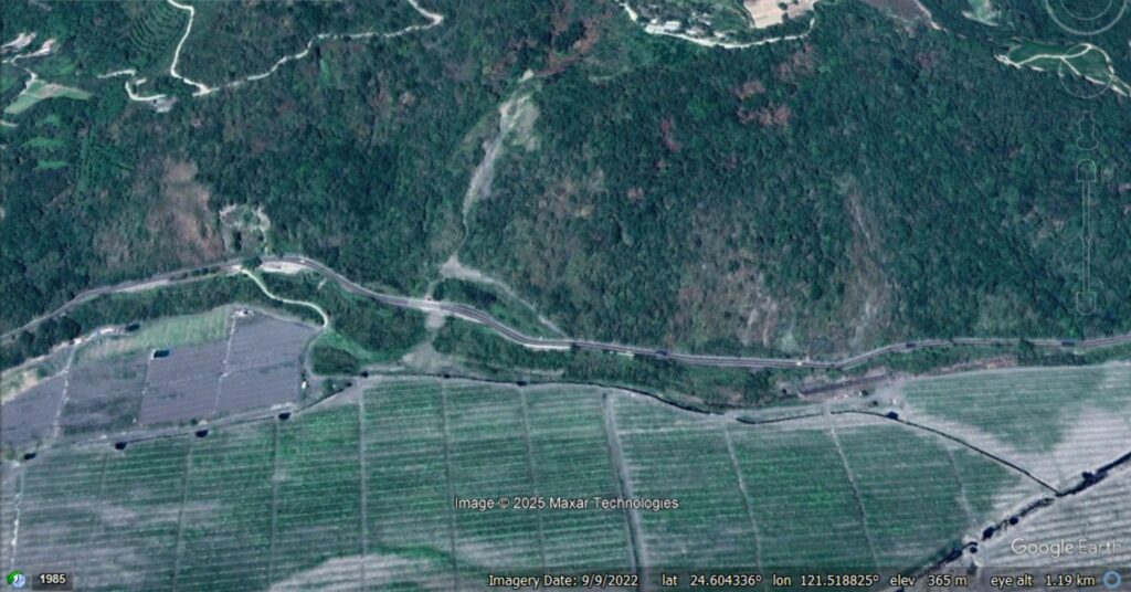
The Cilan Landslide is located at [24.60399, 121.51957]. This is a Google Earth view of the site prior to failure:-
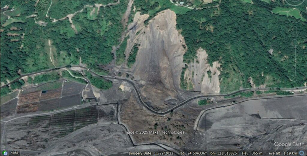
And here is one after the landslide, captured in November 2022:-
And here is a slider to compare the two images:-


Amazingly, the landslide was also captured on a dramatic video, which is on Youtube:-
As the images and the videoshow, this was a large failure (the measured volume is 665,000 cubic metres) that is about 530 metres long, with a vertical difference between the crown and the toe of 220 metres. Whilst a key highway was destroyed, there were no fatalities.
Understanding the failure is where the seismic data becomes really helpful, especially when combined with information from the video. There is perhaps some evidence from a first inspection of the morphology of the landslide and the deposit to suggest that this failure occurred in more than one phase, but this would be difficult to untangle. The seismic data presented by Chang et al. (2025) clearly demonstrates that the Cilan Landslide was a somewhat complex event.
Chang et al. (2025) observe that initially small debris flows and rockfalls occurred around the landslide site. The major failure began at 16:10 local time, but actually consisted of four failures occurring over a 30 second period. The total volume of these failures was about 520,000 cubic metres. These are the events on the video.
About 20 minutes later, a final, smaller landslide occurred, with a volume of about 17,000 cubic metres, involving retrogression of the landslide.
This is a very detailed investigation of failure processes using seismic data, for which the authors deserve much praise. There is increasing evidence that large failures tend to occur in this multiphase manner.
Reference
Chang, J.-M., Yang, C.-M., Chao, W.-A., Ku, C.-S., Huang, M.-W., Hsieh, T.-C., and Hung, C.-Y. 2025. Unraveling landslide failure mechanisms with seismic signal analysis for enhanced pre-survey understanding. Natural Hazards and Earth System Sciences, 25, 451–466. https://doi.org/10.5194/nhess-25-451-2025.