
The Landslide Blog is written by Dave Petley, who is widely recognized as a world leader in the study and management of landslides.

Back in February 2023 I highlighted the large numbers of landslides, and their impacts, associated with the passage of Cyclone Gabrielle in North Island of New Zealand. One landslide, at Manukau Heads, led to the death of a firefighter, whilst there several other near misses and extensive damage.
GNS Science is the organisation in New Zealand that seeks to understand the landslides as a process and their implications for society. Since the passage of Cyclone Gabrielle, a team led by my former PhD student Chris Massey and by Kerry Leith has been mapping the landslides that it triggered. GNS Science has an excellent web page online describing the work, which is being undertaken with a range of other organisations. It is starting to outline the results too. In addition, the New Zealand Herald has a very useful article online about the work.
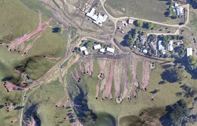
The statistics are startling – the team has mapped 50,000 square kilometres of the landscape, identifying 140,000 landslides. Clearly, mapping such a range of landslides is a very substantial challenge, so the team has used an interesting methodology that locates the landslide source and a polyline, which represents the centre line of the debris tail down to the toe. This image, from GNS Science, shows the approach for a set of landslides triggered by Cyclone Gabrielle:-
In essence, there are four linked reasons for wanting to undertake this type of work. First, we still do not understand the processes that lead to landslide generation on this scale, so there is a driver simply from the perspective of good science. Second, there is of course a need to understand properly what happened in such a catastrophic event, primarily to inform the future response. Thirdly, we need to plan for more of these events as the climate warms. Painstaking investigations provide information about what we should expect in the future as warming continues. And finally, there is a push in New Zealand to develop a landslide predictive system, similar to that in Hong Kong, but over a much larger area. Understanding the relationship between rainfall and landslides is key in such an endeavour.
Since Cyclone Gabrielle, over 1,500 houses have required risk analysis associated with landslide hazard. Mass movements represent both a substantial threat and a major burden on New Zealand, so building a detailed scientific understanding of these events is essential. GNS Science, and its partners, is excellent at publishing the results of the work, so I shall look forward with interest to seeing the outcomes of this fascinating project.