
The Landslide Blog is written by Dave Petley, who is widely recognized as a world leader in the study and management of landslides.

Satellite imagery has now become available of the tailings landslide that affected the Siana gold mine in the Philippines on 11 May 2024.
An interesting image has been captured by Capella Space, a private company that captures very high resolution synthetic aperture radar satellite imagery. This image was captured on 13 May 2024:-
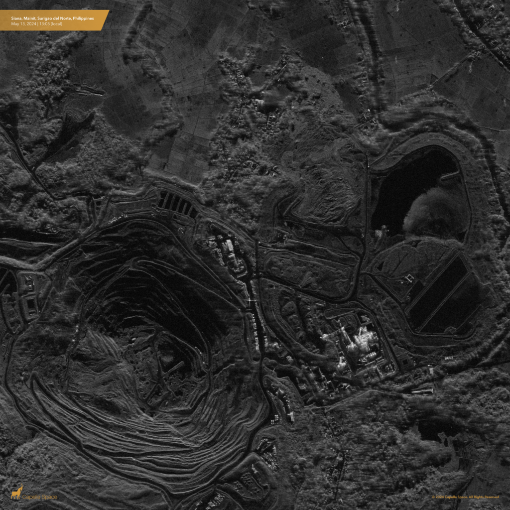
In this visualisation, north is towards the bottom of the image, so the landslide is slightly towards the upper right of the centre. The landslide has moved towards the top of the image. As an aside, this new, high resolution radar imagery is genuinely astonishing; there are many opportunities to use it to understand better the dynamics of recent landslides.
Also now available is Planet Labs imagery, captured on 15 May 2024:-
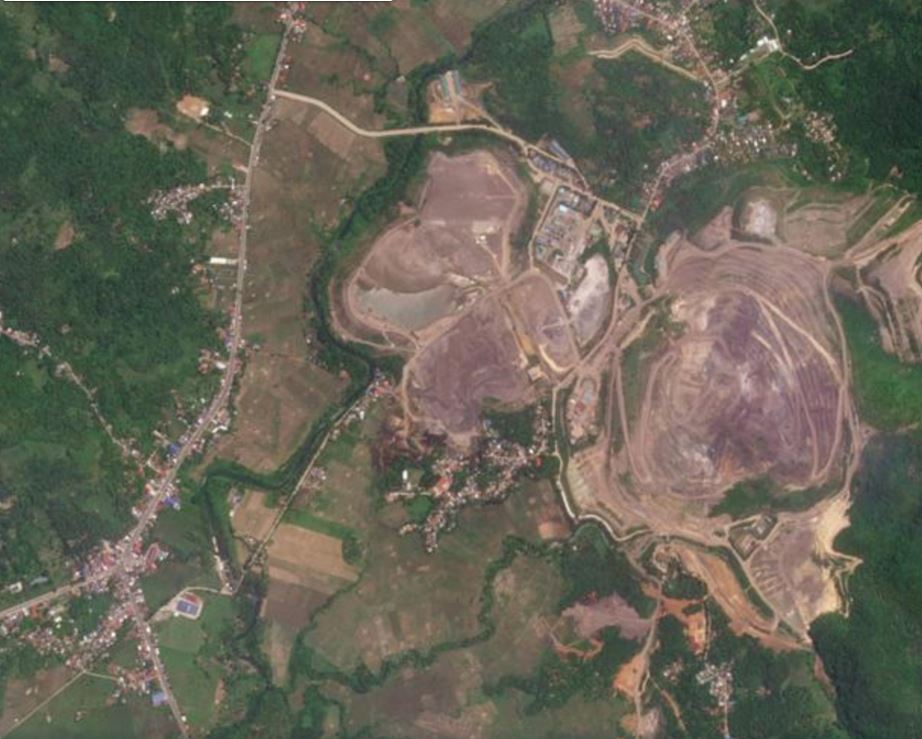
In this case, north is towards the top of the image. TSF3 is in the centre, with the landslide moving towards the south. The slider below should allow a comparison of the site before and after failure (the earlier image was captured on 25 April 2024):-


So what do these images tell us? First, the scale of the landslide is perhaps larger than it might first appear – the width of the breach in the wall of TSF3 is about 230 m, with tailings travelling about 300 m from the crest of the embankment.
Below is a magnified image from Capella Space, showing the failure, rotated now so that north is towards the top of the image (to align with the Planet Labs image):-
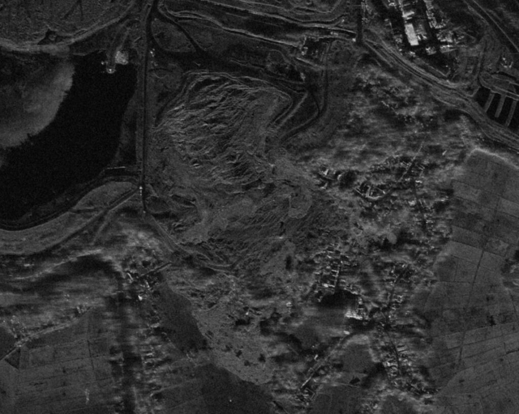
This suggests that the backscarp of the landslide might extend a considerable distance into TSF3. The debris field is complex, I suspect that the failure may have had more than one phase, and that in some areas the tailings have disturbed vegetation on the surface.
It would be fascinating to compare high resolution optical imagery with this image.
The operators of the mine are investigating the failure, as are the authorities in the Philippines. Interestingly, there is some criticism of the Department of Environment and Natural Resources, focusing on its ability to regulate mining activities. Meanwhile, Knight Piésold has put out a statement making it clear that, contrary to many press reports, they were not responsible for the design of TSF3. This element of the statement will be a particular focus:-
“Knight Piésold has not been involved in the mine since 2021 when it was already on care and maintenance and was sold to another party. At that time, the Knight Piésold recommendations for TSF3 embankment buttressing had not been implemented.”
It will be interesting to know what actions were taken to ensure that the embankment at TSF3 was secure. I am sure that the investigations will provide this information in due course, and it would be unwise to speculate ahead of this information being made available.
Reference and acknowledgement
Many thanks to Adam Thomas, Director of Business Development at Capella Space, for his help in obtaining the radar image.
Planet Team (2024). Planet Application Program Interface: In Space for Life on Earth. San Francisco, CA. https://www.planet.com/