
The Landslide Blog is written by Dave Petley, who is widely recognized as a world leader in the study and management of landslides.

As the devastation caused by the catastrophic flooding in the port city of Derna in Libya becomes clear, the media has focused on the damage to the urban area and the appalling stories of loss. Before and after satellite images are now available, together with some mobile phone imagery, that illustrate the scale of the catastrophe. There is no doubt that the magnitude of the damage indicates that this was far more than a rainfall-induced river flood, with the finger of blame being pointed at two dams upstream of the city in Wadi Derna (also spelt Darnah in some places).
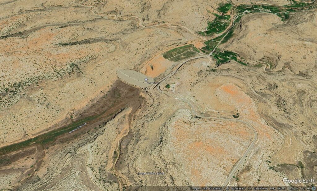
The two dams are clearly visible on Google Earth. The first is located at 32.658, 22.578:-
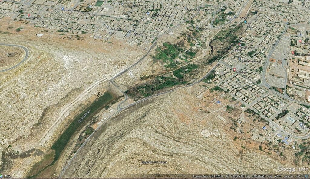
The second is about 1 km above the city at 32.752, 22.631:-
There is an article in Arabic on the News Libya website that explains the history of the dams. It notes that Derna has been subject to a sequence of floods emanating from the Wadi, including major events in 1941, 1959 and 1968. The 1959 flood appears to have been particularly catastrophic.
So, in the 1960s studies indicated that the dams should be constructed to protect the city. The dams were constructed in the 1970s by a Yugoslavian company. The upper dam was called the Al-Bilad Dam, with a storage capacity of 1.5 million cubic metres of water, whilst the lower dam, the Abu Mansour Dam, had a storage capacity of 22.5 million cubic metres. The dams had a core of compacted clay with a carapace of stone.
Planet imagery is now available showing the sites of the two dams after the disaster. This is the upper (Al-Bilad) dam:-
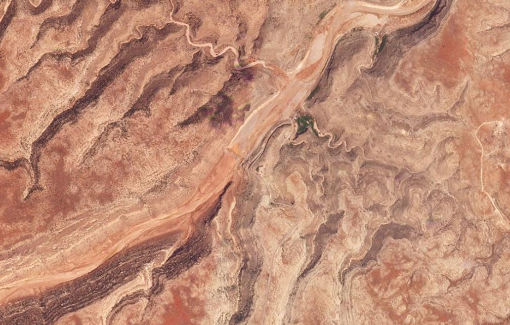
The image clearly shows that the dam has indeed collapsed and been washed away, and that a large flood occurred downstream. The indications are that this was a catastrophic failure.
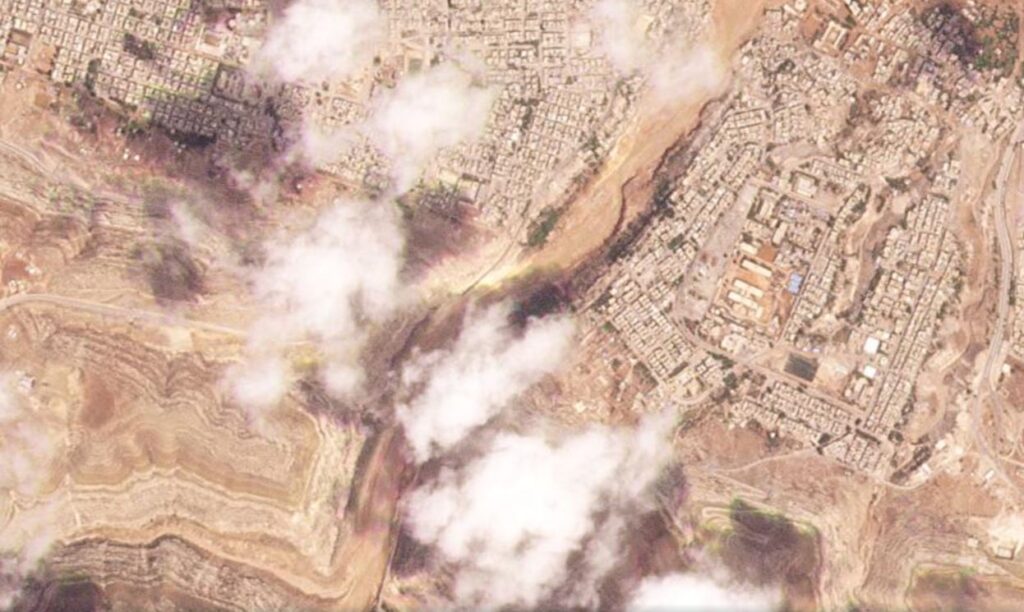
The lower (Abu Mansour) dam has also been lost, although the Planet image is currently partially obscured by cloud:-
Th most likely scenario is a cascading hazard in which the first dam was overwhelmed and collapsed, releasing a torrent of water and sediment downstream. This would have mixed with water in the channel to overwhelm the lower dam, which clearly collapsed catastrophically too. This scenario needs further study.
The location of the lower dam just 1 km upstream of the city was a contributing factor. Such a short distance meant that the flood had almost no opportunity to dissipate, so Derna received the full force of the torrent.
Work is now needed to understand the causes of the disaster. Clearly the rainfall associated with Storm Daniel was extreme – over 200 mm has been reported. This large total might have exceeded the design capacity of the structures. It will be interesting to see whether this total can be attributed to climate change. Derna suffered floods in 1986, but the dams succeeded in managing the water to avoid serious damage to the city. It will be key to compare the 2023 event to previous storms.
There are also claims that maintenance of the dams might have been deficient. These are comparatively old structures (50 years), so are likely to have needed attention.
Finally, of course, a population that has been subjected to conflict and a failed government will have had a high level of vulnerability, which will increase the death toll.
It is worth noting that Derna is now unprotected from further flood events. However, mustering the resources to rebuild the dams is likely to be very difficult given the state of civil society in Libya.