Editors’ Vox is a blog from AGU’s Publications Department.
A recent article in Reviews of Geophysics explores land subsidence drivers, rates, and impacts across the globe. It also discusses the need for improved process representations and the inclusion of the interplay among land subsidence and climatic extremes, including their effects in models and risk assessments. Here, we asked the lead author to explain the concept of land subsidence, its impacts, and future directions needed for improved mitigation.
What is land subsidence?
Land subsidence (LS) refers to the relative sinking or lowering of the Earth’s land surface. LS is a pressing global issue that warrants action since subsidence can adversely impact infrastructure, humans, and the environment across various landscapes and climates (Figure 1). It may be driven by one or more natural processes and/or human activities that compound to cause localized or expansive ground deformation. Differential LS causes structures and roadways to crack and buckle. LS can also reduce the water storage capacity of aquifers. Notably, LS can be recoverable (e.g., natural variations in groundwater levels) or permanent (e.g., overdraft causing irreversible compaction).
Why is it important to understand and monitor land subsidence?
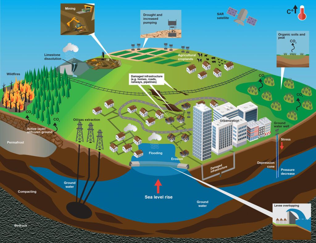
Various LS drivers and physical processes exist and interact with one another (Figure 1). LS is often closely related to natural resources demand, which increases with growing urbanization and megacities. The proximity of LS to critical infrastructure like water conveyance, transportation, and utility systems is a significant concern since LS could cause catastrophic lifeline failures, outages, and/or loss of life. Also, feedbacks between climatic extremes (e.g., droughts, floods, wildfires, heatwaves) and LS impacts exist, but are not fully understood.
Although a chronic hazard, LS may initially go unnoticed as sinking typically occurs slowly. This influences perceived risk and contributes to reactive policies, regulations, and mitigation steps targeting LS and its implications rather than proactive measures. Furthermore, the compounding effects of extreme events and their impacts can exacerbate LS. More pronounced interactions are likely with projected rises in climate extremes.
How do scientists monitor and measure land subsidence across the globe?
Scientists use various techniques and technologies to measure LS, including ground-based surveys, subsurface instrumentation, and satellite-based observations. Satellite-based Synthetic Aperture Radar (SAR) has revolutionized LS monitoring and mapping. It is an active remote sensing system that emits microwave pulses and receives echoes. Such systems can operate under various conditions (e.g., day and night, in cloudy skies) and produce high-resolution imagery. With SAR-based information, scientists can infer surface deformation by computing phase differences between SAR snapshots over a region using techniques like interferometric SAR (InSAR). SAR-based observations commonly inform impact assessments for agriculture, structural health, and resource management.
What are the major natural and anthropogenic drivers of land subsidence?
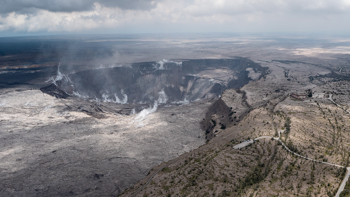
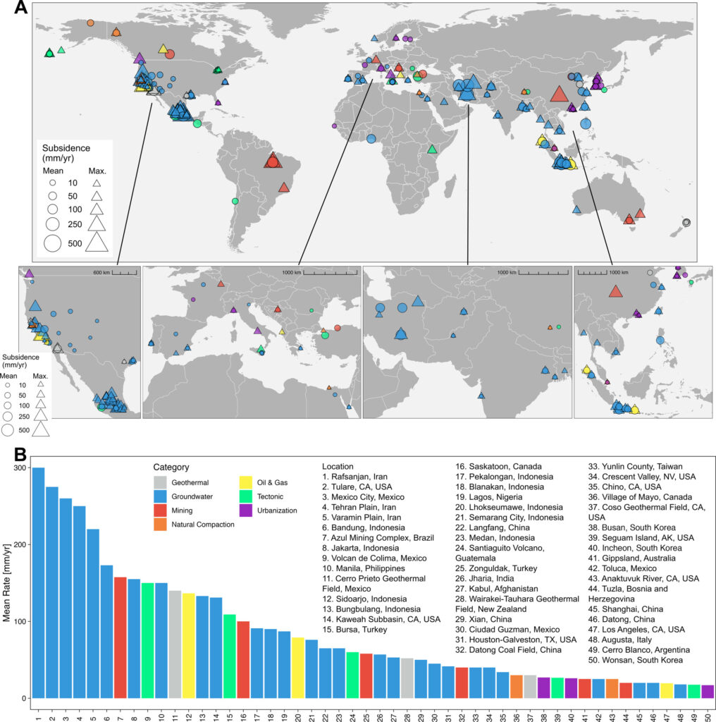
Naturally-occurring processes and human activities can independently drive LS or enhance existing LS rates (Figure 2). Some examples of natural drivers of LS include: natural consolidation, volcanic or tectonic activity, seasonal groundwater level variations, and soil organic material decomposition. Extraction of natural resources (e.g., fossil fuels, groundwater), removal of wetlands and peatlands, and loading from rapid urbanization serve as examples of human-related activities contributing to LS. Natural resource extraction is a leading anthropogenic driver of LS (Figure 1), which often rises with increasing population. Also, extreme events such as wildfires or heatwaves can trigger LS in permafrost areas by thawing the permafrost layer, altering the soil structure, and releasing greenhouse gases that accelerate warming.
How is land subsidence projected to change in the future?
Estimating future LS rates is challenging. Projecting human activities driving LS and the effectiveness of restoration and mitigation efforts is complicated, uncertain, and variable. LS projections also depend on other factors (e.g., infrastructure investments, land use-land cover changes). They are further complicated by uncertain projected hydrologic variables like precipitation. Yet, more people are expected to be exposed to LS with greater economic losses anticipated in the future.
Sea level rise (SLR), rising temperatures, and extreme events often compound LS. Subsiding coastal areas and deltas face higher inundation risk from the compounding effect of SLR. Extreme events and LS impacts are expected to increasingly affect one another (Figures 2-3) as extremes (e.g., drought) intensify with warming. Amidst drought, groundwater levels drop through decreased recharge and increased pumping, often leading to soil compaction and LS. As soils dry and crack, heightened microbial processes decompose soil organic matter and release carbon. Such processes can enhance warming while triggering LS and feedbacks. As temperatures rise, permafrost thaw-driven LS is also expected to expand, increasing the infrastructure at risk for damage and failure.
What additional research, data, or modeling is needed to help track and mitigate land subsidence and its impacts?
Integrated models incorporating multiple LS drivers and processes are necessary for better estimating LS rates, extent, and ramifications at the spatiotemporal resolutions essential for mitigation, adaptation, and policy. Additional data and research are needed to understand the interplay of extreme events, infrastructure, climatic trends, and human activities with LS dynamics and effects (Figure 3), and inform LS mitigation efforts.
Improved climate modeling, management practices, and risk assessments require better representations of LS feedbacks, carbon emissions, and LS processes. Such advancements necessitate accurate, longer, and spatial observations and analyses with improved process understandings. Global adoption of consistent monitoring and reporting frameworks will also support such efforts by leading to new insight into LS observations and regions at-risk for LS, LS-enhanced flooding, etc. Interdisciplinary efforts will help transform science into action focused on LS hazard and risk mitigation.
—Laurie S. Huning ([email protected], ![]() 0000-0002-0296-4255), California State University, Long Beach, United States
0000-0002-0296-4255), California State University, Long Beach, United States
Editor’s Note: It is the policy of AGU Publications to invite the authors of articles published in Reviews of Geophysics to write a summary for Eos Editors’ Vox.