A translation of this article was made possible by a partnership with Planeteando. Una traducción de este artículo fue posible gracias a una asociación con Planeteando.
Gale Sinatra and her husband fled their Altadena, Calif., home on 7 January with little more than overnight bags, taking just one of their two cars.
“We thought we were going to be gone overnight,” Sinatra said. “We thought they’d get the fire under control and we’d get back in.”
When the couple did return, weeks later, it was to dig through the rubble of their former home, burned to the ground by the Eaton Fire.
Though they escaped with their lives, health hazards were not behind Sinatra, her husband (who chose not to be named for this story), and others from their neighborhood. The Eaton and nearby Palisades fires filled the Los Angeles Basin with a toxic haze for days, and cleanup efforts threatened to loft charred particles long after the fires were out.
Teams of scientists from across the country, along with community members, monitored air quality in the weeks following the fire, seeking to learn more about respiratory health risks and inform community members about how to protect themselves.
Urban Fires Versus Wildfires
Inhaling smoke from any fire can be harmful. Smoke contains hazardous components, including volatile organic compounds (VOCs), emitted by burning vegetation and products such as paint and cleaning supplies; and particulate matter, such as dust and soot.
About 90% of the particulate matter (PM) in wildfire smoke is PM2.5, or particles smaller than 2.5 micrometers in diameter—small enough to enter the bloodstream and deep areas of the lungs.
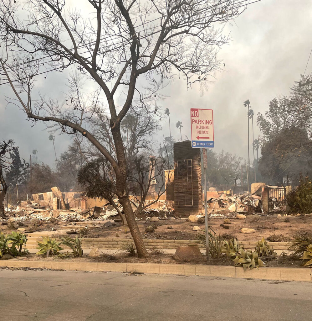
Urban wildfires present their own dangers, because they burn not just through trees and other vegetation but through homes and infrastructure as well.
When Sinatra returned to her former home, she was struck by everything the fire had burned, from her jewelry to her car. “I just found it very eerie standing in my kitchen, going, ‘Where’s my refrigerator?’” she said. “How do you melt an entire refrigerator?”
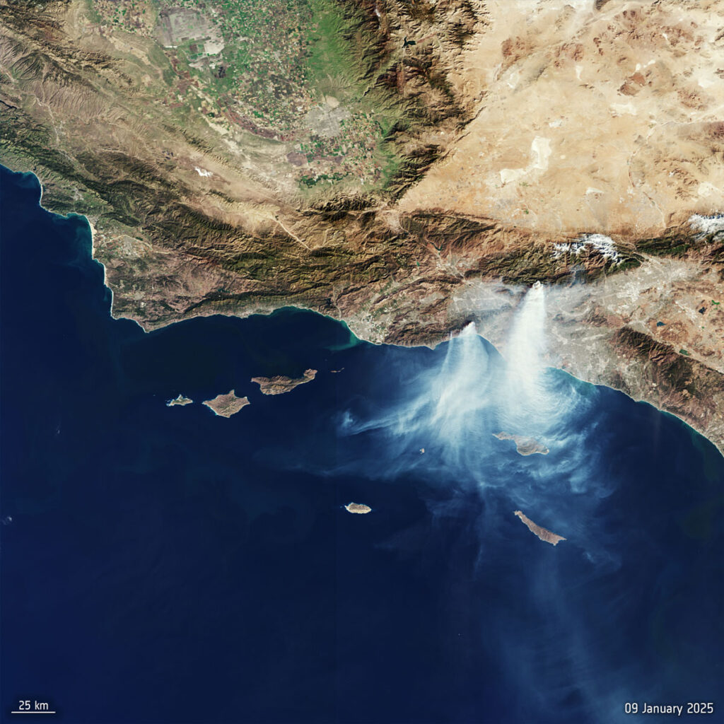
In January 2025, the Palisades and Eaton fires ravaged more than 150 square kilometers across cities and wildlands in Los Angeles County. Even as they were personally affected, LA-area scientists worked diligently to understand how fires at the urban-wildland interface create unique hazards via air, land, and water.
In the future, hot and dry conditions enhanced by climate change will continue to raise the risks of fires like these. The work of these scientists can provide a blueprint for rapid hazard assessment, health risk mitigation, and urban planning in other fire-prone communities.
“From mattresses to carpets to paint to electronics, everything like that burns,” said Roya Bahreini, an environmental scientist at the University of California, Riverside (UCR). Bahreini is also co–principal investigator of the Atmospheric Science and Chemistry Measurement Network (ASCENT), a long-term air quality monitoring project led by the Georgia Institute of Technology, UCR, and the University of California, Davis (UC Davis).
ASCENT, which launched in 2021, has stations across the country, including three in Southern California. During the January fires in Los Angeles, which tore through not only Altadena (an unincorporated inland community) but also neighborhoods along the coast, these stations detected levels of lead, chlorine, and bromine at orders of magnitude higher than usual.
Older houses sometimes have lead paint, asbestos ceilings, or wooden decks and fences treated with preservatives containing arsenic. PVC piping contains chlorine. And flame retardant often contains brominated organic compounds. In these forms, such materials don’t necessarily pose a high risk to human health. But when they are burned and released to the air, they can be dangerous.
Michael Kleeman, a civil and environmental engineer at UC Davis, explained that the short-term mortality associated with high PM2.5 events such as wildfires often comes in the form of a heart attack. But inhaling urban wildfire smoke or the particles kicked up from dust and ash during remediation efforts can present risks that aren’t immediately apparent. “It’s not a heart attack a day or three after the exposure. It’s, like, a cancer risk way down [the road],” Kleeman said. “The long-term exposure [risk] can be insidious.”
Air Quality Maps
Southern California is no stranger to wildfires. (Neither is Sinatra, who has evacuated several times during her 15 years in Altadena.) Frequent droughts in the Los Angeles Basin result in large swaths of parched vegetation. The infamous Santa Ana winds, which blow into the basin from the east and northeast, can cause fires to quickly grow out of control, as was the case in the Palisades and Eaton blazes.
Real-time air quality maps, such as those hosted by the South Coast Air Quality Management District (AQMD) and U.S. EPA, pull from several sources to provide data year-round. More detailed data come from sophisticated instruments set up by the agencies themselves; South Coast AQMD hosts 32 permanent air monitoring stations throughout Los Angeles, Orange, Riverside, and San Bernardino counties.
Less detailed but more widespread data on particulate matter come from networks of off-the-shelf air quality measuring tools, such as PurpleAir monitors and Clarity Sensors, that are set up by residents or community organizations.
“It turns out that the areas that the fires were in had [a] really, really dense network of these low-cost sensors,” said Scott Epstein, planning and rules manager at South Coast AQMD. “When you combine that with our regulatory network, we had very good coverage of fine particle pollution.”
This density meant researchers could watch the Eaton and Palisades wildfire plumes as they traveled toward the coast.
An existing AQMD station in Compton, about 23 miles (37 kilometers) south of the Eaton Fire, showed highly elevated levels of toxic metals, including arsenic and lead, between 7 and 11 January as the plume passed over the area. These levels returned to normal within a few days. ASCENT instruments in Pico Rivera, about 14 miles (23 kilometers) south of the Eaton Fire, recorded a 110-fold increase in lead levels from 8 to 11 January.
Permanent air quality measuring stations like these offer one source of public information that residents like Sinatra could consult to make decisions about when to stay indoors or return to a burned area. But when the Palisades and Eaton fires broke out, researchers from AQMD and other institutions set out to supplement these efforts with more granular monitoring.
Mobilizing Quickly
In January, researchers from Harvard University; the University of California, Los Angeles (UCLA); the University of Texas at Austin; the University of Southern California (USC); and UC Davis launched the Los Angeles Fire Human Exposure and Long-Term Health Study, or LA Fire HEALTH.
While many Los Angeles residents, including Sinatra, were still under evacuation orders, LA Fire HEALTH researchers were traveling into evacuation zones.
One such researcher was Nicholas Spada, an aerosol scientist who headed down to Los Angeles from UC Davis on 14 January to set up four cascading impactors in Santa Monica (near the Palisades Fire), Pasadena (near the Eaton Fire), Hollywood, and West Hills. These briefcase-sized instruments act like coin-sorting machines, Spada said: They take an air sample, then sort particles into eight different size categories. They take an air sample, then sort particles into eight different size categories, ranging from 10 micrometers (about 1/9 the average width of a human hair) to 90 nanometers (about 1/1,000 the width of a human hair). The instruments collected eight samples every 2 hours until 10 February.
A cascading impactor allows scientists to “associate the particle size profiles with time,” Spada said. The instrument “picks up the changes in the smoke plumes as the fire progresses from active to smoldering to being put out, and then to the mitigation effects.”
The measurements showed that not only were toxic elements such as lead and arsenic present in the air throughout the sampling period but also a high proportion of their mass—about 25%—was in the form of ultrafine particles (on the order of nanometers). Such particles aren’t filtered by N95 masks and can penetrate deep into the body when inhaled, Spada explained.
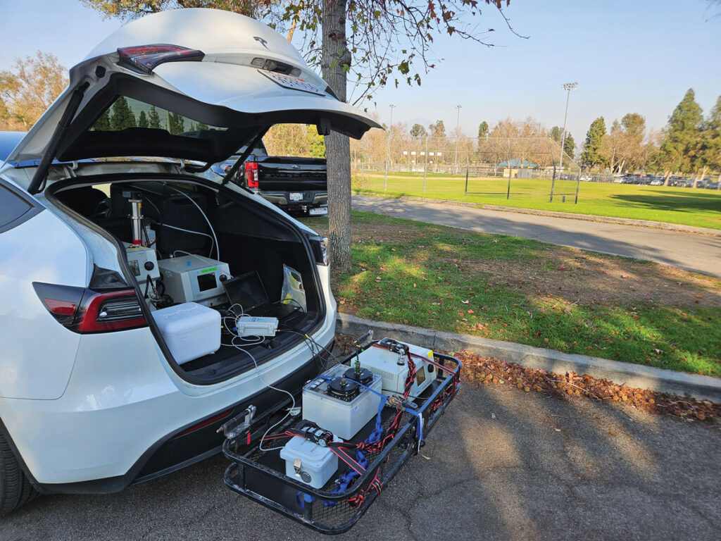
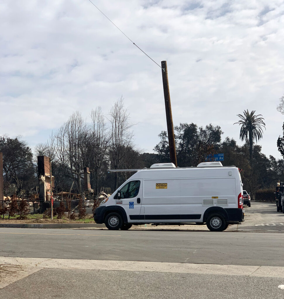
A team of University of Texas researchers arrived in a van that doubled as a mobile laboratory on 2 February, at which point the fires were out but dust-disturbing remediation efforts had begun. They found that outdoor air quality in the weeks after the fires was back to prefire levels and within EPA guidelines. Indoor samples—especially from homes within the burn zones—showed higher levels of VOCs compared with the outdoor samples.
Neighbors Lend a Hand
Community members got in on the efforts to monitor air quality.
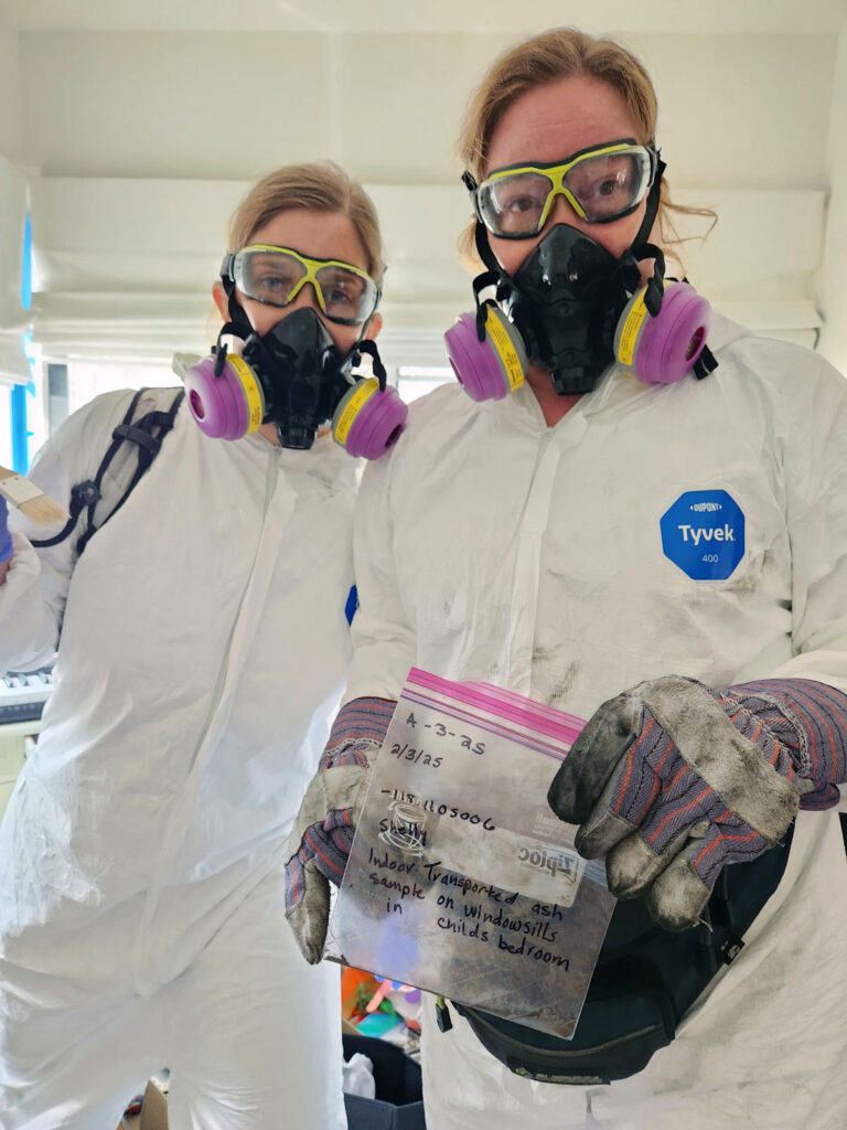
Southern California community members got in on the efforts to monitor air quality, too. Melissa Bumstead and Jeni Knack, codirectors of Parents Against Santa Susana Field Laboratory, worked with researchers to create and distribute flyers about appropriate measures regarding personal protective equipment, as well as a self-sampling protocol for residents who wanted to gather ash samples from their own properties.
About twice a week from 14 January to 19 February, they gathered air and ash samples in Pasadena, Altadena, Santa Monica, Topanga, and Pacific Palisades, then sent them to laboratories, including Spada’s, for testing. Arsenic in all of the ash samples and lead in about a third of them exceeded EPA regional screening levels. Spada noted in communications to residents that these screening levels are based on what’s safe for ingestion by a child and are relatively conservative.
“This is going to help people in the next iteration of fires to know what to do,” Bumstead recalled telling residents in sampling areas.
After the Ashes
The next fire, Sinatra said, is something that weighs on her as she and her neighbors consider the prospect of rebuilding.
When rain finally arrived in Southern California on 26 January, it helped extinguish the fires and tame the dust disturbed by remediation efforts, reducing the risk that people would inhale toxins.
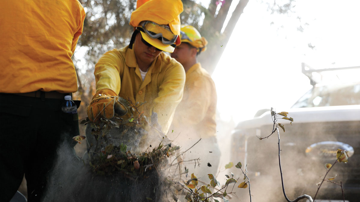
Still, those toxins were also present in the soil and water. When Sinatra and her husband returned to the charred site of their home, they took every precaution they’d heard about from the news, the EPA, community leaders, and neighbors: They wore respirators, hazmat suits, goggles, and two pairs of gloves each to protect themselves.
Concerns about potential long-term consequences of the air they had already breathed, as well as the soil beneath them, linger as they wait for more data.
“Everyone feels there’s a significant chance of a future fire,” Sinatra said. We’re “wondering about whether it would be safe to live up there, [in] regards to the soil quality and the air quality, and whether it’s going to happen again.”
—Emily Dieckman (@emfurd.bsky.social), Associate Editor