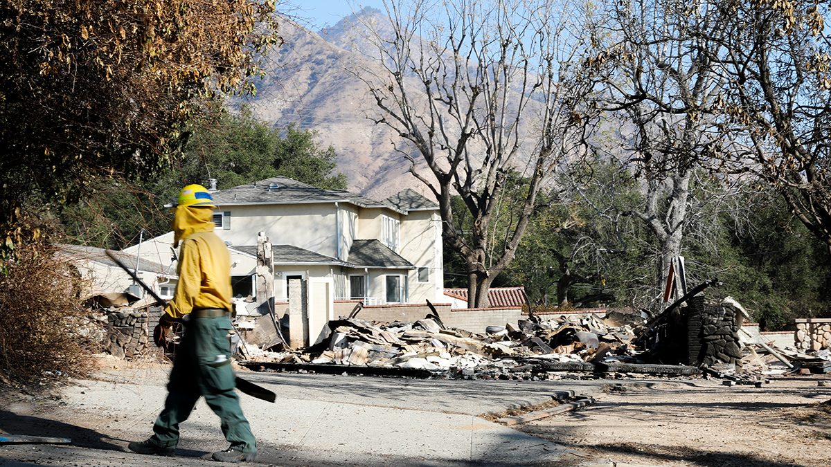
Over 24 days in January, the Eaton and Palisades fires burned nearly 38,000 acres of Los Angeles County. Whole neighborhoods were destroyed, 29 people died, and thousands were displaced. The conditions that led to the fires were estimated to be 35% more likely because of climate change, and damage to public and private infrastructure made the blazes among the costliest wildfire disasters in U.S. history.
In the wake of the fires, multiple local, state, and federal disaster response agencies mobilized to contain the flames, document dangers, and communicate those findings to the public. Agencies’ emergency response playbooks are tried and tested and often require interagency cooperation.
Within this massive, coordinated effort in postfire monitoring and response, where have non-agency scientists with relevant skills and a desire to help fit in?
This is a question Michael Lamb has wrestled with this year. Lamb is a geomorphologist at the California Institute of Technology (Caltech) in Pasadena who was evacuated from his home and left without power for several days when the Eaton Fire tore through Altadena.
Lamb, who researched debris flow patterns after the 2009 Station Fire in the Angeles National Forest, wondered how to apply his knowledge to help with this latest disaster, and whether he should. He worried that members of his lab group, by inserting themselves into the disaster response apparatus, might inadvertently confuse official communications or make it harder for first responders to do their jobs.
“We don’t want to take time away [from agency scientists], especially when they’re in the middle of the emergency management part of work,” Lamb said.
Lamb wasn’t alone in his concern, or in his desire to help. The areas of Los Angeles County affected by the Palisades and Eaton fires are home to a high concentration of scientists who work or study at the area’s many scientific institutions. Some of them study fires and fire impacts and realized they could help, while many outside that niche were surprised to find that their work might have new, immediate applications close to home.
Scientists Spot Need
When the Palisades Fire was still burning in early January, Adit Ghosh watched the coverage at home on television. Ghosh, an Earth science graduate student at the University of Southern California (USC) in Los Angeles, had helped evacuate his in-laws and some of his friends from at-risk areas and couldn’t go in to work because campus was closed.
“They were showing the fires nonstop,” Ghosh recalled of news reports. In one broadcast, the camera zoomed in on a house in Mandeville Canyon near Topanga State Park. “I saw it on TV catching fire and then burning to the ground.”
“He took us to this house. Then it clicked. This is the house that I saw burning on TV.”
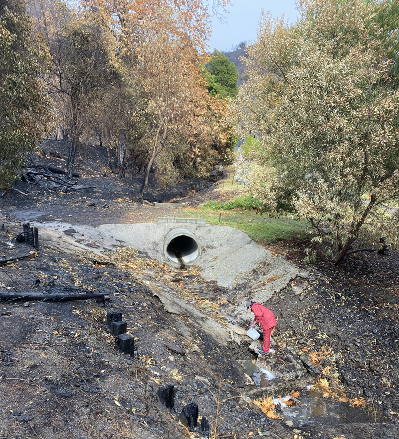
By the third week in January, Ghosh was back in his geochemistry class. His adviser, who works closely with the professor teaching the course, suggested a way for Ghosh and his fellow graduate students to contribute to the ongoing efforts to understand contamination in water runoff. They were eager to help in whatever ways they could.
That weekend, Ghosh went out with a team of other USC students to collect water runoff in burned areas. They hoped to analyze the samples for chemicals that might prove harmful to human and environmental health. A helpful resident showed the team around the burned area, pointing out places they might collect samples from.
“He took us to this house,” Ghosh said. “Then it clicked. This is the house that I saw burning on TV.”
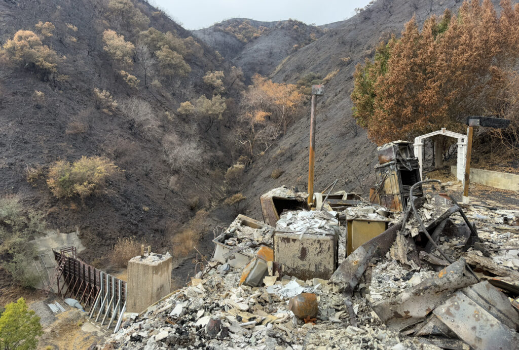
The postfire landscape and environmental conditions can change rapidly. Many scientists felt a sense of urgency to collect samples of ash, dust, soil, and water, as well as to study sediment and debris built up along the mountainside, because much of these data are considered “perishable,” Lamb explained.
Lamb’s team rushed to obtain flight permits and conduct drone flyovers of debris channels along the San Gabriel Mountains above Altadena. Knowing that weather reports anticipated rain soon after the fires, debris flow researchers wanted to obtain postfire, prerain lidar scans of the channels’ topographies to better understand how debris accumulates and what conditions can trigger dangerous flows.
If measurements weren’t taken quickly enough, information about immediate postfire impacts could be washed away. They shared their results with disaster response agencies and affected communities.
Serendipitous Science
In the wake of such a disaster, doing something, anything, to help others can be a powerful tool of healing and recovery.
“As soon as they were safe, people really wanted to contribute,” said Kimberley Miner, a climate scientist and representative of NASA’s Disasters Response Coordination System (DRCS) at the Jet Propulsion Laboratory (JPL) in Pasadena, Calif. NASA and JPL coordinated to fly the Airborne Visible/Infrared Imaging Spectrometer 3 (AVIRIS-3) instrument to survey damage immediately after the fire.
The first AVIRIS-3 flight on 11 January was serendipitous, explained Robert Green, principal investigator for AVIRIS-3 at JPL. The instrument had already been installed on a plane and approved to fly over a completely different area. The team was able to divert the flight path to cover the Eaton burn area instead.
“There were folks working out of hotel rooms [on all of that imagery] while they were evacuated.”
“There were folks working out of hotel rooms while they were evacuated,” Miner said. On some science teams, only one or two people had not been displaced.
The AVIRIS team has been on the scene after some of the most infamous disasters in modern U.S. history. The team flew an earlier version of the instrument over the ruins of the World Trade Center after the terrorist attack on 11 September 2001 to look for asbestos and residual hot spots burning under the rubble. After the 2010 Deepwater Horizon disaster, AVIRIS-3 data yielded the first estimates of how much oil had been released into the Gulf of Mexico.
Even in the context of those disasters, Green said that flying over the L.A. burn scars was “heartbreaking and poignant.”
“It’s especially poignant, I would say, because it is a local disaster,” Green said. “But for 9/11, the Gulf oil spill, or wherever we contribute, our team is committed to offer information via this unique spectroscopy to be helpful.”
The first AVIRIS-3 flyover provided some of the first aerial data assessing the scope of the fires. NASA’s DRCS provided those data to federal and state disaster response teams, and those data helped justify and expedite approval for subsequent flyovers.
Getting Involved but Not Being in the Way
As official emergency responders worked to contain the fires and rapidly document the damage, collecting samples from the air, ground, rivers, or ocean outside of those efforts presented logistical quandaries.
The USC team that Ghosh worked with to collect water runoff samples had been organized within his department and went out on its own volition. But getting to sample sites was a challenge.
“We’re trying to focus on whatever we can get our hands on, essentially, because access is really hard,” he said earlier this year. In some burned areas where runoff sampling would have yielded important science results, for example, the National Guard had restricted access to prevent looting.
“Even in sites that are open, the residents still didn’t really want us hanging around over there. And understandably, because their house almost burnt down,” Ghosh said. When members of his team encountered resistance from residents, he said, they respectfully moved to another location.
“Something that we can try to help with more as research scientists is to think about real forward-looking measurements.”
Lamb said that his research group considered a broad range of science that they might contribute before contacting government agencies operating in the area. “We reached out via email to people…leading debris flow hazard teams and just said, ‘We are interested in helping. These are some of the capabilities we have. We also don’t want to get in the way. Please let us know if this can be of help.’”
Lamb’s team was told it could help by monitoring the accumulation of sediment and debris in ravines on the slopes of the San Gabriel Mountains, and they gained approval to fly drones over certain landslide-prone areas. Those aerial lidar measurements will be helpful in assessing the ongoing risk of debris flows and landslides and also in monitoring for future hazards.
“Emergency managers and the federal agencies are mostly tasked with trying to deal with the immediate situation,” Lamb said. “Whereas something that we can try to help with more as research scientists is to think about real forward-looking measurements.”
Their lidar flights focused on areas of burned mountainside rather than on urban areas. “It’s sad to say, but in some of the areas that were really devastated by the fires, there aren’t homes there [anymore] to be damaged by the debris flows,” Lamb said.
Working with Their Communities
The public messaging that agencies provide is critical for residents to find out about the immediate risks they face, but non-agency scientists also have found ways to engage these communities deeper in the scientific discoveries that are helping them stay safe.
As crews started containing the fires, scientists at the Natural History Museum of Los Angeles County (NHMLA) recognized the need to collect and analyze samples of the ash, not only for the immediate emergency response but also to curate a catalog that scientists could use for longer-term and future studies. Because they have a small staff, the museum’s team solicited community members for ash samples rather than going in to the field themselves.
“They just lost their homes. They want to be treated with respect.”
“We didn’t want to reach out right away, because that would appear as insensitive and not really caring about the people but rather more caring about the science,” said Aaron Celestian, curator of mineral sciences at NHMLA. But once it started raining, they couldn’t wait any longer.
The museum’s community science team approached their existing community partners about collecting ash and found that people were already doing it themselves. The team pivoted, instead showing people how to collect ash without risking personal health or contaminating the samples.
“We didn’t want anybody to do anything that would have any kind of health effects on them long term,” Celestian said. “We had to develop a protocol that could be understood by the community at large, and so that we get the best kind of science out of it in the end.”
Celestian analyzed his first sample on 27 January, measuring the chemical composition of forest ash. He plans to compare the results with those from urban ash.
Then came the question of how to communicate the results. Celestian and the museum’s communications team came up with a two-pronged approach. First and foremost, they consulted with the community member who sent in the ash sample. “They get to decide on how they want their samples to be treated and communicated with everybody else,” Celestian said.
With a resident’s permission, the ash sample was entered into a museum collection for other scientists to check out and analyze. They received 11 samples for the collection.
“Even though I’m collecting the data, it really is their property,” Celestian said. “That’s a big part of making them feel comfortable, making them feel confident in the results.”
“They just lost their homes,” he emphasized. “They want to be treated with respect,” he said, adding that the samples “are really like a family member’s ashes.”
At the same time, Celestian recognized the importance of transparency and that timely information can not only protect people but also help them feel confident in their safety. He began live-streaming his analysis on social media and his blog using anonymized samples.
“People want to know,” Celestian said.
Lamb’s group took a similar approach. They shared their lidar data directly with emergency response managers so they could be incorporated into official responses. They also communicated directly with the public. Lamb had been scheduled to give a public science talk in late January, and he decided to center the science of postfire debris flows.
“I was going to talk about something completely different, and I changed the topic last minute because of this very heightened community interest in understanding what’s happening in the mountains,” Lamb said. Nearly 900 people showed up to listen.
Strong, and Mixed, Emotions
Having a way to help after a disaster—whether through distributing supplies or figuring out whether playground soil has elevated lead levels—can aid community recovery and empower personal healing. In some, it can also evoke a sense of duty.
“I think we have a responsibility to use our skill sets to help the greater Los Angeles area where we live,” Ghosh said. Logically, he knew that sampling water runoff and analyzing it for harmful chemicals is an important part of postfire recovery. But sometimes, it didn’t feel like enough.
“You go up there and you’re collecting water, and people have almost lost their homes,” Ghosh said. “It feels like, ‘Why the hell are you collecting water?’ It may not seem in the moment as important a thing to do. I definitely felt that.”
Studying the risks from these fires “does feel more personal.”
Some residents questioned what the sampling team was doing and whether they were focusing on the right problems. “But we also had neighbors who were like, ‘Thank you so much for doing this, coming out and helping us understand whether we can drink our water, or whether it’s safe to be out,’” Ghosh said. “In fact, some people even let us in to their house, and [we] collected tap water from their house.” Ghosh and his colleagues shared the results of those in-home water tests directly with the homeowners when they got them.
“It’s a lot of mixed emotions,” he added.
Studying the risks from these fires “does feel more personal” for local scientists, Lamb said. “We know people that live in those areas. There’s faculty from Caltech and graduate students that live there, and postdocs and friends. It’s very close to where we live and work. It certainly adds more motivation to try to do anything that we can to help.”
—Kimberly M. S. Cartier (@AstroKimCartier), Staff Writer