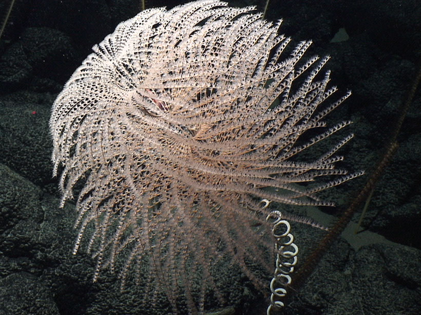
On 15 June 2006, when U.S. President George W. Bush signed the proclamation creating the Papahānaumokuākea Marine National Monument (PMNM), he probably wasn’t thinking about underwater morphology. To fully understand the coral reefs and marine ecosystems that the monument was created to protect, however, scientists need to have a detailed picture of the seafloor features, home to corals and other species, as well as the geologic history of the area.
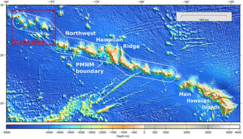
Thanks to a recent, multi-institution expedition, such a picture now exists for the previously sparsely mapped northern half of the monument (see Figure 1). Our team discovered new seafloor features that will not only inform conservation efforts but also enable geologists and geophysicists to revise their understanding of Hawaii’s complex geologic past.
Specifically, data should help scientists answer fundamental questions about the area’s regional geology. For instance, which seamounts were truly formed because of Hawaiian hotspot volcanism, and which seamounts were not?
A Little-Known Sanctuary
PMNM comprises all the atolls and banks of the Hawaiian Archipelago northwest of the islands of Kaua`i and Ni`ihau. Encompassing a vast 366,631-square-kilometer area—roughly 85% the size of California—it is one of the world’s largest marine sanctuaries.
Because of the monument’s remoteness and enormous size, marine geologists knew relatively little about the details of its seafloor topography prior to the expedition. As late as 2013, scientists had mapped less than half of the monument’s seafloor, mostly in the easier to reach southern half.
A Mapping Campaign
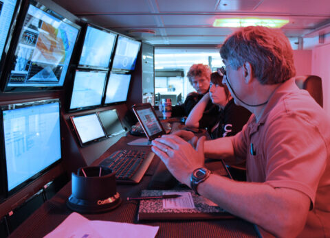
To increase our understanding of the geologic history and deepwater habitats present in the sparsely mapped northern half of the monument, our team of researchers from five collaborating institutions—University of Hawaii, U.S National Oceanic and Atmospheric Administration (NOAA) Pacific Islands Benthic Habitat Mapping Center, PMNM, University of Sydney, and NOAA Observer Program—embarked, during spring 2014, on a 36-day cruise on the Schmidt Ocean Institute’s R/V Falkor. Using multibeam sonar systems, we collected topographic and backscatter data over a 61,000-square-kilometer area, along with nearly 18,000 kilometers of continuous gravimetric data.
Our data reveal fascinating new geologic details about the monument’s seafloor features. Among other findings, our surveys provide, for the first time, complete high-resolution data for all 19 seamounts in this part of the monument. We also fill in gaps in the existing coverage of the Kure, Midway, and Pearl and Hermes atolls.
Challenging Assumptions
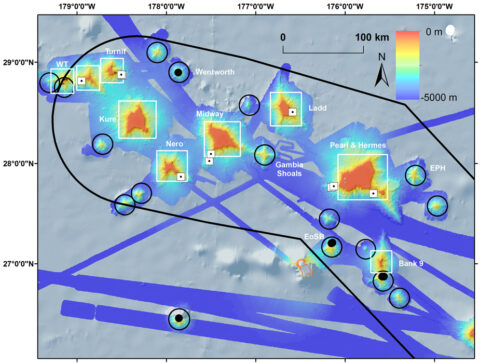
Previous radiometric age dating of dredged lavas indicated that four seamounts (Ladd, Nero, Academician Berg, and Turnif) and two atolls (Midway and Pearl and Hermes) are of Hawaiian origin, meaning that they formed 20–30 million years ago (see Figure 2). Analysis of lavas dredged from three other seamounts (Wentworth, an unnamed seamount east of Salmon Bank, and Bank 9) indicated that these originated during the Cretaceous, 82–92 million years ago [Clague and Dalrymple, 1975; Garcia et al., 1987; O’Connor et al., 2013].
Pringle and Dalrymple [1993] suggested that these latter three could be part of a so-called Wentworth chain extending south from Hess Rise. Our new survey data support their conclusion and further reveal that this part of the PMNM may contain as many as 15 Cretaceous seamounts. These Cretaceous seamounts have not been covered by Hawaiian volcanism and, as a result, may be more exposed at this end of the chain. Thus, when taken together, the seamounts in this area may have a more complex intersection of old and new features than previously thought.
Furthermore, our data reveal the unnamed seamount east of Salmon Bank (EoSB in Figure 2) to be a guyot, or underwater plateau, with discernible terraces that we think mark submerged ancient shorelines at 1640–1450 meters below sea level. These are up to 1000 meters deeper than the deepest terrace on Nero, the closest Hawaiian seamount. Because terraces that formed at the same time are expected to subside at the same rate (i.e., be at the same depth), the difference in depths supports our hypothesis that the terraces on these two features formed at different times and are unrelated.
Data from the cruise also reveal two other deep guyots. The first is an unnamed seamount east of Pearl and Hermes (EPH in Figure 2) that has a single summit terrace at 1380 meters below sea level. The second is Gambia Shoals, which was known to be a seamount but not a guyot—it has three terraces between 1755 and 1700 meters below sea level. Prior to our cruise, the presence of guyots in the monument was unknown.
Revealing New Features
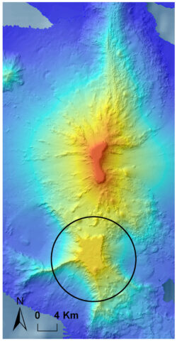
We discovered that the deep southern part of Bank 9 has three deep terraces between 1450 and 1332 meters below sea level. A previous research group dredged this southern flank and found it to be Cretaceous in age (~82 million years old [see O’Connor et al., 2013]). In contrast, the adjoining northern flank has a summit terrace at 117 meters below sea level and no corresponding deeper terraces matching those found to the south (Figure 3).
This morphology suggests that Bank 9 is a composite seamount created when a Hawaiian volcano erupted just north of a Cretaceous seamount already present on the seafloor.
This is an exciting insight, given that if Bank 9 were truly a Cretaceous seamount, Hawaiian volcanism would have had to halt its eruptive activity, a feat that would be difficult to explain.
Another unnamed seamount west of Turnif (WT in Figure 2) has characteristics that suggest a similar composite seamount. It has a deep southern terrace at 1100 meters below sea level that appears to be the partially buried summit of yet another deep guyot. Similar to Bank 9, it has no corresponding terraces on the northern flank, where the summit reaches a depth of 263 meters below sea level.
The other deep seamounts in this area are conical, indicating that they have never reached the ocean surface. We interpret their relatively smaller sizes and greater depths, which are similar to those of other known Cetaceous seamounts in the region, as evidence of Cretaceous origin. Of these, Wentworth is the only one in the monument that has been dredged by research vessels; data from dredge samples suggest that lavas at the seamount’s surface erupted 71–85 million years ago [Pringle and Dalrymple, 1993].
Remaining Questions
We will need to do further sampling and analysis to confirm the ages of the rest of the deep guyots and other conical seamounts as well as to track how the Pacific Plate moved over the past 100 million years. As a start, we are examining our new gravity data to distinguish seamounts that formed in the Cretaceous on young seafloor from Hawaiian seamounts that formed on older seafloor and are supported regionally by bending of the seafloor crust.
In preliminary analyses of the new gravity data, some of these deep seamounts appear to have gravity anomalies consistent with features of Cretaceous origin.
Further sampling may happen within the next few months. This summer, NOAA’s R/V Okeanos Explorer is scheduled to work in the PMNM and will broadcast live video from its remotely operated vehicle over the internet. Intended dive sites include two of the deep guyots as well as Bank 9.
Seeking Habitats
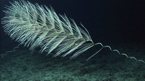
Exploratory mapping expeditions such as ours provide high-resolution imagery that reveals complex morphological features, such as ancient reef terraces and rift zone ridges. Most of the seamounts we mapped have well-formed rift zone ridges that may serve as habitats for deep-sea corals and sponges. In addition, flank failure scarps—places that have slid off the volcanic flanks along faults—are quite common and may also serve as habitats for deep-sea corals and sponges.
The first step toward conservation is knowing what’s there. Our data provide a quantum leap in that direction.
We also defined three previously unknown deep guyots, identified two potential composite seamounts, and advanced scientists’ understanding of the complex interaction of the upper northern Hawaiian Ridge with the preexisting Cretaceous seamount chain.
Without data like these, scientists might misinterpret radiometric analyses of rock dredges and fail to discover new potential habitats for important deep-sea species.
As with so many ecosystems, the first step toward conservation is knowing what’s there. Our data provide a quantum leap in that direction.
Data are freely available at the Marine Geoscience Data System website.
Acknowledgments
We thank the Schmidt Ocean Institute for the Falkor ship days, PMNM for additional funding to support salaries, and the National Science Foundation for grant EAR-1423686 to G. Ito for student support and the lease of the gravimeter from Woods Hole Oceanographic Institution.
References
Clague, D., and G. Dalrymple (1975), Cretaceous K-Ar ages of volcanic rocks from the Musicians Seamounts and the Hawaiian Ridge, Geophys. Res. Lett., 2, 305–308.
Garcia, M., D. Grooms, and J. Naughton (1987), Petrology and geochronology of volcanic rocks from seamounts along and near the Hawaiian ridge: Implications for propagation rate of the ridge, Lithos, 20, 323–336.
O’Connor, J., B. Steinberger, M. Regelous, A. Koppers, J. Wijbrans, K. Haase, P. Stoffers, W. Jokat, and D. Garbe-Schönberg (2013), Constraints on past plate and mantle motion from new ages for the Hawaiian-Emperor Seamount Chain, Geochem. Geophys. Geosyst., 14(10), 1525–2027.
Pringle, M., and G. Dalrymple (1993), Geochronological constraints on a possible hot spot origin for Hess Rise and the Wentworth Seamount chain, in The Mesozoic Pacific: Geology, Tectonics, and Volcanism, Geophys. Monogr. Ser., vol. 77, edited by M. S. Pringle et al., pp. 263–277, AGU, Washington, D. C.
Author Information
Christopher Kelley, John R. Smith, Joyce Miller, Jonathan Tree, Brian Boston, Michael Garcia, and Garret Ito, School of Ocean and Earth Science and Technology, University of Hawaii, Honolulu; email: [email protected]; Jeremey Taylor and Frances Lichowski, Pacific Islands Benthic Habitat Mapping Center, U.S. National Oceanic and Atmospheric Administration (NOAA), Honolulu, Hawaii; Daniel Wagner and Jason Leonard, Papahānaumokuākea Marine National Monument, Honolulu, Hawaii; Belinda Dechnik, Geocoastal Research Group, University of Sydney, Sydney, Australia; and Daniel Leurs, NOAA Observer Program, Honolulu, Hawaii
Citation: Kelley, C., et al. (2015), New insights from seafloor mapping of a Hawaiian marine monument, Eos, 96, doi:10.1029/2015EO030235. Published on 28 May 2015.
Text © 2015. The authors. CC BY-NC 3.0
Except where otherwise noted, images are subject to copyright. Any reuse without express permission from the copyright owner is prohibited.

