A translation of this article was made possible by a partnership with Planeteando. Una traducción de este artículo fue posible gracias a una asociación con Planeteando.
In December 2019, Reykjanes Peninsula, which juts into the Atlantic Ocean southwest of Iceland’s capital city of Reykjavík, began experiencing intense seismic swarms. Since then, scientists at the Icelandic Meteorological Office have been tracking and monitoring deformation of Earth’s surface as magma pushed (intruded) itself into the shallow crust. Three initial intrusions occurred near Mount Thorbjörn, just outside the town of Grindavík. A fourth intrusion slightly inflated the peninsula’s westernmost tip, and a fifth intrusion leapfrogged back east, beyond Grindavík, to Krýsuvík, according to Sara Barsotti, an Italian volcanologist and coordinator for volcanic hazards at the Icelandic Meteorological Office.

More than a year after this unrest began, on 24 February, a large earthquake measuring magnitude 5.7 jolted the peninsula between Keilir and Fagradalsfjall, “marking a turning point,” Barsotti said.
Soon thereafter, the Icelandic Meteorological Office’s seismic network recorded more than 50,000 earthquakes on the peninsula. Using the monitoring tools at their disposal, scientists found a corridor of magma between Keilir and Fagradalsfjall, said Barsotti. This magma flowed underground for approximately 3 weeks, with earthquakes defining the edges of the subterranean chamber. Then, both seismicity and deformation plummeted.
At that point, some scientists hypothesized that the intrusion would freeze within the crust, said Kristín Jónsdóttir, a seismologist at the Icelandic Meteorological Office. “Then,” she said, “the eruption started.”
Keeping Crowds Safe
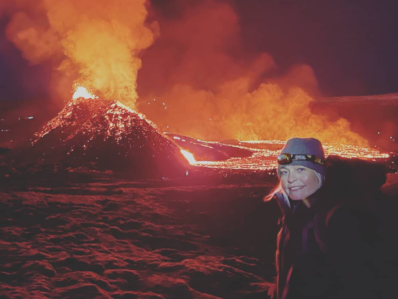
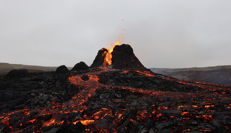
On 19 March, lava began to erupt from the edge of the intrusion near Fagradalsfjall, and Icelanders flocked to the mountains above the fissure to picnic, play football, or simply observe nature’s lava light show. “Icelanders…feel this is part of their life,” said Barsotti. “They really want to enjoy what their country is capable [of giving] them.”
https://twitter.com/ruteinars/status/1376191476342923264
Because crowds continue to visit the eruption, the Icelandic Meteorological Office meets daily with Iceland’s Department of Civil Protection and Emergency Management to ensure the safety of volcano watchers, Barsotti explained. A rescue team is always present, and they use handheld sensors to detect gases that could be dangerous.
“The big challenge,” Barsotti said, is “[foreseeing] the opening of new vents.” What began as a single vent now boasts eight craters in a row. “People should be [able] to go, but [we must keep] them far away from what we consider to be hazardous.”
The Icelandic Meteorological Office keeps vigil over this volcano with a variety of techniques. For example, InSAR (interferometric synthetic aperture radar), a satellite-based method, allows scientists to measure differences in topography at centimeter scale. GPS stations help track how the ground itself moves. Passive satellite imagery helps track the progress of toxic clouds, like sulfur dioxide.
Seismic Monitoring of the Future
Geoscientists from across Europe have been exploring distributed acoustic sensing, or DAS, to monitor seismicity near Mount Thorbjörn. In April, Sebastian Heimann, a scientist at Helmholtz Centre Potsdam, in Germany, presented the latest results from the ongoing study at the 2021 Annual Meeting of the Seismological Society of America.
At a molecular level, DAS works because fiber-optic cables contain impurities, explained Hanna Blanck, one of Heimann’s coauthors and a doctoral student at the University of Iceland. By sending a laser pulse through a cable, the light will encounter these impurities, she said. When that happens, the light scatters, and a small portion returns toward the laser source. By continuously measuring the returning signal, scientists can look for changes that indicate the cable has moved. Earthquakes have distinct signatures that help differentiate them from, for example, the rumble of a passing car.
DAS provides several advantages to traditional seismic networks, including higher spatial resolution, said Blanck. Traditional seismic networks are spaced kilometers apart, whereas the spatial resolution Heimann used along the 21-kilometer-long cable was a scant 4 meters.
“We caught more small earthquakes compared to the conventional methods [likely because] we have many more records along the fiber,”said Philippe Jousset, a coauthor and geophysicist at Helmholtz Centre, describing previous work using the same cable near Mount Thorbjörn. In that study, Jousset and his colleagues, including Blanck, compared the catalog of earthquakes recorded by both DAS and traditional seismic stations.
“Propagating magma increases the pressure in the surrounding crust, causing many small earthquakes,” said Blanck. More data mean detecting more small earthquakes, which should yield a better picture of magma movement.
However, “[DAS] is still in its research phase,” said Jónsdóttir, “so it’s not being routinely used by monitoring agencies.” In the future, she said, it will likely complement more established methods in seismology.
Nevertheless, seismologists and volcanologists often investigate secrets of Earth that cannot be seen, Jónsdóttir said, so holding a freshly formed piece of basalt as lava spews in the background—after hypothesizing the existence of an intrusion in that very location—provides incredible validation.
—Alka Tripathy-Lang (@DrAlkaTrip), Science Writer
Citation:
Tripathy-Lang, A. (2021), Chasing magma around Iceland’s Reykjanes Peninsula, Eos, 102, https://doi.org/10.1029/2021EO158786. Published on 25 May 2021.
Text © 2021. The authors. CC BY-NC-ND 3.0
Except where otherwise noted, images are subject to copyright. Any reuse without express permission from the copyright owner is prohibited.