• About
  • Sections
  • Topics
    • Climate
    • Earth Science
    • Oceans
    • Space & Planets
    • Health & Ecosystems
    • Culture & Policy
    • Education & Careers
    • Opinions
  • Projects
    • Postcards From the Field
    • ENGAGE
    • Editors’ Highlights
    • Editors’ Vox
    • Eos en Español
    • Eos 简体中文版
    • Print Archive: 2015–2025
  • Science Policy Tracker
  • Blogs
    • Research & Developments
    • The Landslide Blog
  • Newsletter
  • Submit to Eos
  • AGU.org
  • Career Center
  • Join AGU
  • Give to AGU
  • About
  • Sections
  • Topics
    • Climate
    • Earth Science
    • Oceans
    • Space & Planets
    • Health & Ecosystems
    • Culture & Policy
    • Education & Careers
    • Opinions
  • Projects
    • Postcards From the Field
    • ENGAGE
    • Editors’ Highlights
    • Editors’ Vox
    • Eos en Español
    • Eos 简体中文版
    • Print Archive: 2015–2025
  • Science Policy Tracker
  • Blogs
    • Research & Developments
    • The Landslide Blog
  • Newsletter
  • Submit to Eos
Skip to content
  • AGU.org
  • Career Center
  • Join AGU
  • Give to AGU
Eos

Eos

Science News by AGU

Support Eos
Sign Up for Newsletter
  • About
  • Sections
  • Topics
    • Climate
    • Earth Science
    • Oceans
    • Space & Planets
    • Health & Ecosystems
    • Culture & Policy
    • Education & Careers
    • Opinions
  • Projects
    • Postcards From the Field
    • ENGAGE
    • Editors’ Highlights
    • Editors’ Vox
    • Eos en Español
    • Eos 简体中文版
    • Print Archive: 2015–2025
  • Science Policy Tracker
  • Blogs
    • Research & Developments
    • The Landslide Blog
  • Newsletter
  • Submit to Eos

Iceland

Scientists wearing bright yellow safety vests stand in various places amid an expanse of dark volcanic rock with barren hills in the background.
Posted inFeatures

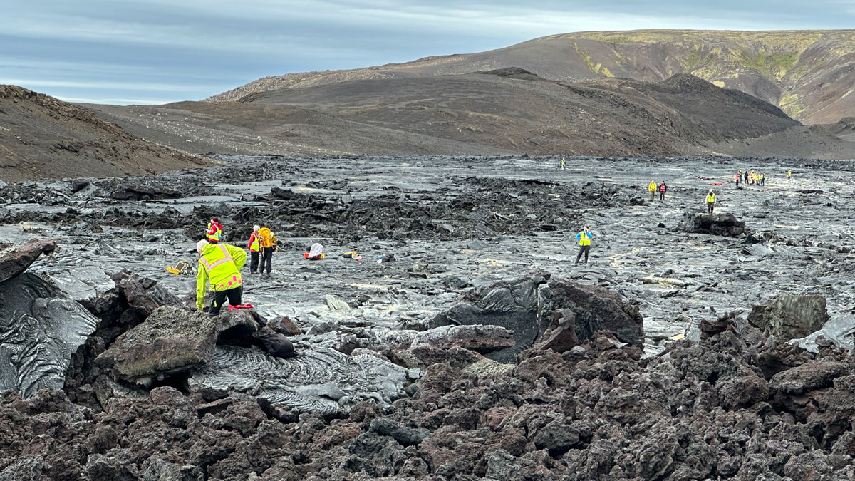
Discovering Venus on Iceland

by Debra L. Buczkowski, Jennifer L. Whitten, Scott Hensley, Daniel C. Nunes and Marc Jaeger 23 January 202623 January 2026

Scientists trekked across Icelandic lava flows that served as stand-ins for Venus’s volcanic landscapes, testing tools and methods the upcoming VERITAS mission will use when it reaches the planet.

Superficie cubierta de nieve con manchas oscuras de tierra al descubierto. Sale vapor de algunas manchas.
Posted inNews

A medida que el Ártico se calienta, los suelos pierden nutrientes clave

Javier Barbuzano, Science Writer by Javier Barbuzano 24 October 202524 October 2025

El cambio climático calienta tanto el aire y el océano, como el suelo, donde los procesos clave que determinan la fertilidad y la captura de carbono operan en un delicado equilibrio.

Snow-covered surface with dark patches of soil uncovered. Steam is rising from some patches.
Posted inNews

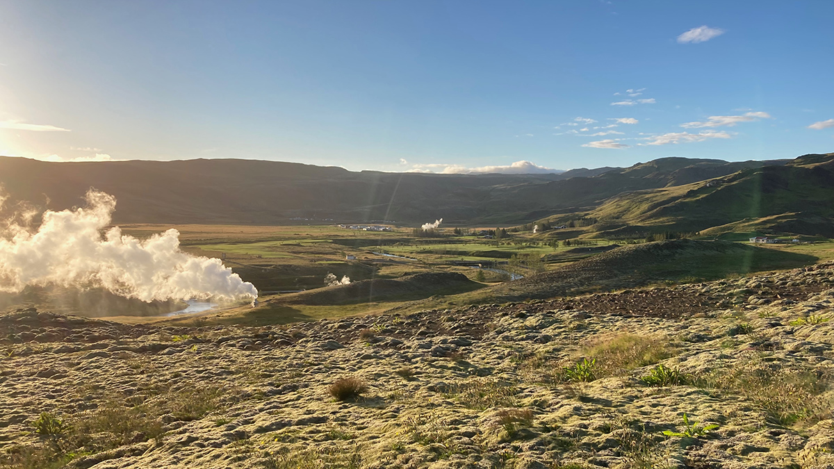
As the Arctic Warms, Soils Lose Key Nutrients

Javier Barbuzano, Science Writer by Javier Barbuzano 1 August 202524 October 2025

Climate change heats not only the air and the ocean but also the soil, where key processes that determine fertility and carbon sequestration operate in a fine-tuned balance.

Maps and graphs from the paper.
Posted inEditors' Highlights

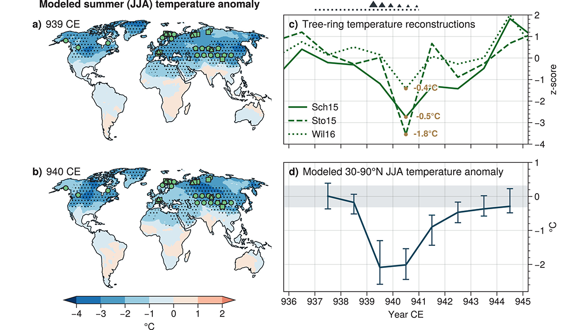
Revised Emissions Show Higher Cooling in 10th Century Eruption

by Lynn Russell 16 May 202515 May 2025

The associated cooling from the Eldgjá eruption is larger than previously predicted and better matches tree-ring temperature reconstructions based on updated estimated emissions.

Map of the Iceland’s Reykjanes Peninsula.
Posted inEditors' Highlights

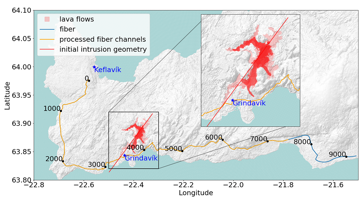
Observing Magma-Induced Seismic Velocity Changes with Fiber-Optics

by Marcos Moreno 26 February 202526 February 2025

A new high-resolution method for tracking volcanic activity utilizes fiber-optic sensing to detect magma intrusion by measuring seismic velocity changes.

Photos of calcite crystals in a basalt core.
Posted inEditors' Vox

Turning Carbon into Stone: Unlocking Mineralization in Fractured Rock

by Haylea Nisbet and Hari Viswanathan 29 January 202529 January 2025

Carbon mineralization is a promising solution for mitigating greenhouse gas emissions, but we must learn to optimize the complex interplay between reactions and mechanics in fractures to develop a scalable solution.

Google Earth image of a part of the the study by Booth and Pétursson (2025) into Holocene bedrock landslide occurrence around Eyjafjörður, North-Central Iceland. The image shows multiple bedrock landslides.
Posted inThe Landslide Blog

The timing of landslides in areas of permafrost thawing

by Dave Petley 27 January 202527 January 2025

The Landslide Blog is written by Dave Petley, who is widely recognized as a world leader in the study and management of landslides. There is a no scientific doubt that human activity is driving rapid warming of the terrestrial climate, and that this is amplified in high latitude and high mountain environments. An inevitable, and […]

Two mountains beneath a blue sky with clouds are reflected into the body of water beneath them.
Posted inResearch Spotlights

Thawing Permafrost Helped Trigger Ancient Icelandic Landslides

Sarah Derouin, Science Writer by Sarah Derouin 22 January 202522 January 2025

New research shows that warming beginning about 13,000 years ago contributed to a proliferation of landslides in Iceland.

Illustrations from the study.
Posted inEditors' Highlights

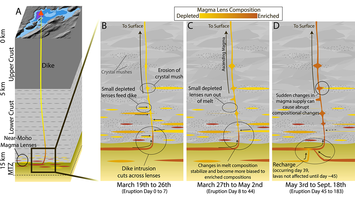
Magma Diversity in Iceland

by Peter Zeitler 19 December 202419 December 2024

Iceland’s recent basalt eruptions originated at the crust-mantle boundary and show chemical variability over remarkably short timescales of weeks, suggesting exchanges between diverse magma sources.

Vistas desde el aire durante la noche, varias brillantes fuentes de lava estallan a lo largo de una fisura lineal, con columnas teñidas de naranja elevándose sobre ellas. Las luces de una ciudad están a lo lejos.
Posted inResearch Spotlights

En una rara oportunidad, investigadores observan la formación de los valles islandeses

Sarah Stanley, Science Writer by Sarah Stanley 9 September 20249 September 2024

Durante el período previo a las recientes erupciones volcánicas cerca de la ciudad de Grindavík, científicos documentaron la formación de grabens en tiempo real.

Posts pagination

1 2 3 … 5 Older posts
A view of a bridge, with the New Orleans skyline visible in the distance between the bridge and the water. A purple tint, a teal curved line representing a river, and the text “#AGU25 coverage from Eos” overlie the photo.

Features from AGU Publications

Research Spotlights

Denitrification Looks Different in Rivers Versus Streams

16 January 202616 January 2026
Editors' Highlights

Kyanite Exsolution Reveals Ultra-Deep Subduction of Continents

23 January 202622 January 2026
Editors' Vox

Bridging the Gap: Transforming Reliable Climate Data into Climate Policy

16 January 202616 January 2026
Eos logo at left; AGU logo at right

About Eos
ENGAGE
Awards
Contact

Advertise
Submit
Career Center
Sitemap

© 2026 American Geophysical Union. All rights reserved Powered by Newspack