
When the Polynesian ancestors of the Māori first arrived in Aotearoa New Zealand, they used fire to clear some of the forest for agriculture, to facilitate hunting, to claim occupation of territories, and to honor their ancestor Mahuika, the goddess of fire.
The smoke from those fires traveled much farther than anyone imagined. A recent study in Nature, using an array of ice core records from Antarctica, has revealed that black carbon from those fires was carried on the westerly winds halfway around the Southern Ocean and deposited in the ice covering an island off the Antarctic Peninsula.
Lead author Joe McConnell from the Desert Research Institute (DRI) in Reno, Nev., said the research team didn’t set out to look for anthropogenic impacts in Antarctica. They planned to map natural variations in soot deposition in the ice over the past 2,000 years using a sophisticated analysis technique developed in the DRI lab. The research was part of an effort to improve climate models. (Black carbon aerosols absorb light and contribute to atmospheric warming.)
But when McConnell and his colleagues compared the ice core from James Ross Island to five others from different parts of the Antarctic mainland, they found something unexpected.
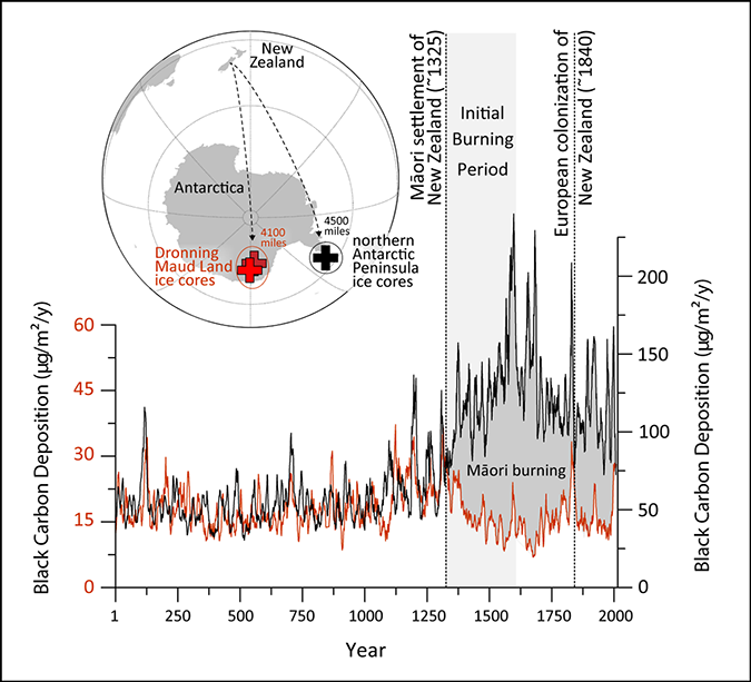
For the first 1,300 years, the ice cores all told the same story. But around 700 years ago—1297, plus or minus 30 years, to be precise—the core taken from the peninsular island sharply diverged from the rest. There, black carbon levels almost tripled over the ensuing centuries, whereas the ice cores from continental Antarctica stayed relatively stable.
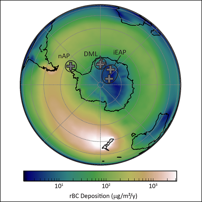
Atmospheric modeling (using the powerful flexible particle dispersion model) showed that for the soot particles to have landed only on the Antarctic Peninsula—which sticks up like a thumb into the prevailing westerly flow—they had to have come from a landmass located south of 40° latitude. The only possible candidates were Patagonia, Tasmania, and New Zealand.
“Anything that’s emitted at 40°–60° south is going to get caught up in that westerly belt and make a big doughnut around Antarctica,” said McConnell. “The beauty of this whole study is that the James Ross Island ice core in the peninsula is at least 1,000 kilometers away from any potential burning area.…It’s an unusual situation where the record is extremely sensitive to any changes in emissions from those three locations.”
When the scientists looked into the charcoal records from lake sediments in those places, they found that wetter climate conditions in both Tasmania and Patagonia during the past 700 years actually led to less burning than usual. Charcoal records from New Zealand, however, showed the opposite: a dramatic fire spike after 1300, just when the black carbon started appearing in the Antarctic Peninsula ice core. It’s also roughly when archaeological evidence suggests the first Māori arrived.
Carbon in Context
For McConnell, the date is a smoking gun. “I suspect this will be the earliest large-scale impact on the environment that we’ll ever see from a nonindustrial society,” he said. (Some of his earlier work has traced the lead emissions of the Roman Empire and medieval Europe via Arctic ice cores.)
The new study caused some controversy in New Zealand, where it was noted that the authors were all from elsewhere, and one New Zealand academic called it an example of helicopter science.
Dan Hikuroa, an Earth systems scientist and senior lecturer in Māori studies at the University of Auckland, said that when research makes a commentary on Indigenous Peoples that have in the past been the target of colonial science, an awareness of the sociocultural context is important. “I think that [such] awareness is absent in this paper,” he said.
“To really understand fully what’s going on in the Southern Hemisphere, we need this large spatial coverage.”
Hikuroa, who is expert at weaving Indigenous Knowledges with science, says the researchers missed an opportunity to incorporate Māori knowledge of fire into what is already a multidisciplinary study.
In other ways, though, the research is groundbreaking. “It’s the first time anyone’s looked at an array of black carbon records from Antarctica,” said Holly Winton, a Rutherford Postdoctoral Fellow at the Antarctic Research Centre at Te Herenga Waka—Victoria University of Wellington in New Zealand.
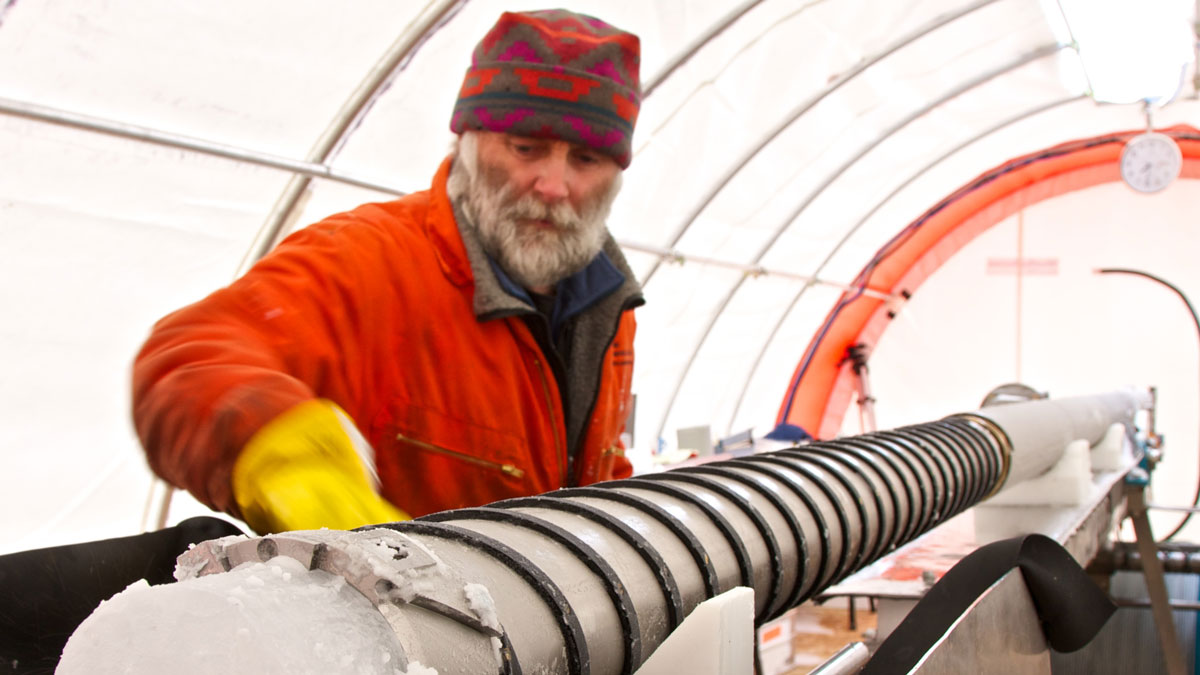
Because of the logistical difficulties and expense involved in hauling a core hundreds of meters long out of the ice in a remote Antarctic location and shipping it to a purpose-built lab, most studies are based on a single ice core. McConnell’s team used six.
“Having a spatial array of ice core records is the dream we’re all trying to reach,” said Winton. “To really understand fully what’s going on in the Southern Hemisphere, we need this large spatial coverage.”
Diverging Fire Stories
Winton remained puzzled, though, by discrepancies between the story the Antarctic Peninsula ice core tells about burning in Aotearoa and that preserved in the charcoal records found in lake sediments across New Zealand. Both show a sharp increase in fire around 1300, but the ice core shows soot levels peaking in the 16th and 17th centuries, whereas the lake sediments show burning falling away, then rising to a new peak around 1840, coinciding with mass European immigration and land clearing.
For McConnell, that divergence simply shows local, catchment-level paleofire records aren’t particularly accurate when scaled up—but Winton wondered whether there’s something else going on as well.
“The New Zealand local fire record and the Antarctic black carbon record look quite different around the 16th and 17th centuries after the 13th century initial rise. To me that raises exciting questions about other factors that could regulate the ice core signal, such as changes in atmospheric processes or shifts in climate oscillations. What about changes in the hydrological cycle?”
Chemical analysis of biomarkers in the soot in these and other ice cores could provide more clarity about what kind of vegetation was burned, she said, and perhaps help to resolve the puzzle. “It would be really interesting to further explore what was going on during that time period.”
Ultimately, said McConnell, the study will help make climate models involving black carbon more accurate—and it’s a reminder, too, that even the remotest parts of Earth can be impacted by human activities in surprising, invisible ways.
—Kate Evans (@kate_g_evans), Science Writer
This news article is included in our ENGAGE resource for educators seeking science news for their classroom lessons. Browse all ENGAGE articles, and share with your fellow educators how you integrated the article into an activity in the comments section below.
27 October 2021: This article has been updated to correctly identify the work of Pricilla Wehi. We regret the error.