
Aerial photos taken high above Rwanda are helping scientists monitor trees and determine how much carbon is locked in the verdant resource. The approach, detailed in a newly published study, revealed that most of the country’s trees lie outside its forests, although conservation and reforestation efforts need to address all ecosystems.
Inside or outside forests, trees are important for mitigating climate change, said Maurice Mugabowindekwe, a doctoral candidate in geoinformatics and remote sensing at the University of Copenhagen and lead author of the new research. They are the ultimate carbon capture and storage machines, he said.
“The entire woodland ecosystem plays a huge role in locking up carbon, including the living wood, roots, leaves, deadwood, surrounding soils, and its associated vegetation,” explained Mugabowindekwe, adding that Article 5 of the Paris Agreement encourages countries to reduce deforestation, enhance carbon sinks, and conserve forests.
Rwanda Sets the Pace
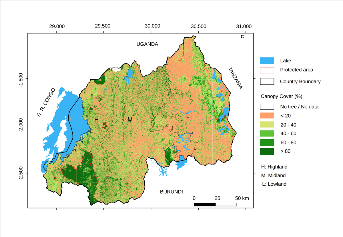
Rwanda became the first country in the world to complete a national inventory of all overstory trees.
With the new approach, Rwanda became the first country in the world to complete a national inventory of all overstory trees (defined as the dominant foliage in a canopy) and their stored carbon.
Rwanda’s diverse ecosystems, representative of many African landscapes, made the country an ideal place for the development and implementation of the approach, Mugabowindekwe said. Furthermore, Rwanda has committed to restoring about 80% (2 million hectares) of the country’s land area by 2030 under the United Nations’ Reducing Emissions from Deforestation and Forest Degradation (REDD+) initiative.
Many African countries, including Rwanda, use field inventories to regularly count and monitor forest trees, but the process is labor-intensive and does not consider trees growing outside of forests, Mugabowindekwe said. In addition to forests, trees dot the country’s savanna, woodlands, fragmented agroecosystems, and urban areas. Because these stands are not included in counts, estimates of carbon benefits are often incomplete, resulting in inadequate natural resource management, he added.
Another hurdle in compiling a tree inventory is the relatively rough spatial resolution of most satellite data. This previously has forced researchers to focus on measuring bulk properties, such as the proportion of a landscape covered by a tree, said John Diisi, coordinator of geographic information systems and mapping at the National Forestry Authority in Uganda.
By using a more precise approach, “Rwanda has set the pace for the East African countries by carrying out this tree mapping study,” said Diisi, who was not involved in the research. “We can benchmark from their success and the technology they used to map trees in the region.”
Machine Learning
“Trees are referred to as the ‘lungs of the Earth.’”
“Trees are referred to as the ‘lungs of the Earth,’” said Mugabowindekwe. During photosynthesis, plants take in sunlight, water, and carbon dioxide to create energy, releasing oxygen into the atmosphere. A mature tree can absorb about 22 kilograms (48 pounds) of carbon dioxide a year, he said.
Mugabowindekwe and his colleagues used aerial images and deep learning—a subset of machine learning—to map the location, size, and carbon stock of each overstory tree across Rwanda’s various ecosystems.
The researchers manually identified tree crowns in a subset of images and then used that sample to teach a computer program to recognize similar features in other images. A tree’s shape, color, and texture are unique to each species, so the program was able to identify and map trees it had not seen during the training, said Martin Brandt, a professor at the University of Copenhagen and a coauthor of the research. Tree characteristics such as crown and trunk size are also related to the amount of carbon they store—larger trees lock in more carbon, although the relationship is species dependent. The researchers measured the height, diameter, and crown diameter of various species in the field and used these measurements to estimate carbon stocks from aerial and satellite images throughout Rwanda.
Beyond Rwanda
The analysis of aerial and satellite images revealed that forests account for only 11% of Rwanda’s trees but 51% of its carbon stocks. Conservation, regeneration, and sustainable management of natural forests may therefore be more effective at mitigating climate change than similar efforts on plantations, Mugabowindekwe said.
Rwanda has been active in implementing large-scale restoration projects, and in 2019 the Ministry of Environment reported that forest cover reached 30.4% of the country’s land area (over 700,000 hectares).
Mugabowindekwe said the new approach can help other “countries and jurisdictions to monitor the progress of ongoing landscape restoration projects such as the AFR100—an initiative to restore at least 100 million hectares across Africa by 2030.”
Elias Nyandwi, a researcher at the University of Rwanda, agreed that Earth observation and remote sensing technologies used in the new research could be integrated into conservation and climate change mitigation projects.
Mugabowindekwe and other scientists intend to extend their approach to more African countries, such as Kenya, Tanzania, and Uganda, and hope researchers from those countries will collaborate to make such work a reality at national scales, Brandt said.
—Hope Mafaranga (@mafaranga), Science Writer