If we want to understand the impacts of a warming planet, we must first learn how its coldest regions are faring. Melting ice leads to sea level rise, but our understanding of the properties of ice sheets and the ways ice streams transport fast flowing ice and sediment from ice sheets to ocean basins has been incomplete.
Now, researchers led by Chloe Gustafson, a geophysicist and postdoctoral researcher at the Scripps Institution of Oceanography, have confirmed scientific suspicions, uncovering significant groundwater amid sediment below ice sheets in Whillans Ice Stream in Antarctica.
“If we want numbers we can be confident in…for sea level rise contributions from ice sheets, we have to get this component right.”
“It’s this missing process that hasn’t been considered in our conceptual models of how ice streams work,” Gustafson said of the study, which was published in Science. Scientists aren’t yet sure how these groundwater systems will affect the ice sheet above them, but they represent a new and potentially weighty factor in modeling the behavior of ice sheets.
The groundwater “has potential to shape how the ice sheets evolve dramatically,” said Stanford glaciologist Dustin Schroeder, who was not involved with the study. “If we want numbers we can be confident in…for sea level rise contributions from ice sheets, we have to get this component right.”
Although ice streams cover a tiny percentage of Antarctica, they’re responsible for most ice flow from the continent’s interior to the ocean. Whillans Ice Stream moves ice about 2 meters per day; other nearby streams, which range from hundreds to thousands of kilometers in length, are faster.
Looking Deeper Beneath the Ice
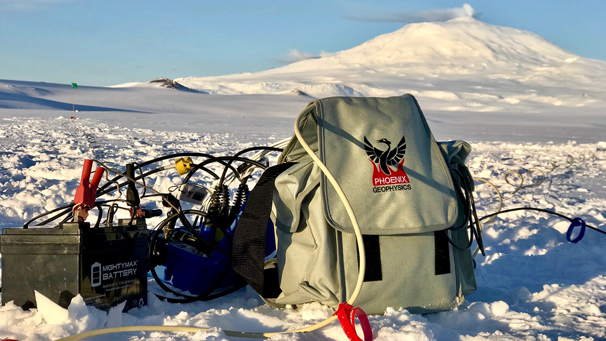
Gustafson and her collaborators observed groundwater and sediment using magnetotellurics (MT), a method that harnesses natural variations in Earth’s electromagnetic fields to map subsurface properties, similar to how an MRI (magnetic resonance imaging) details the inner workings of the human body. They also gathered passive seismic data to confirm and supplement MT findings.
Past research focused on shallow hydrologic systems, using techniques such as drilling through the ice to sample sediments below it, right where ice meets earth. Current models that predict the flow of ice streams include a film of water just millimeters thick atop a much thicker layer of sediment, or till. In the past, modelers believed the till sat atop an impermeable layer of bedrock. This turned out to be untrue.
“It’s not bedrock beneath the till, it’s actually sediments,” Gustafson said. “There’s groundwater within those sediments that can flow up and down, so it’s like an aquifer.” Water moving within the sediments can contribute to the ice base, help lubricate the ice flow, or even slow ice flow by pulling water away from the base of the ice.
“We can think about the sediments holding the water as a water-saturated sponge,” Gustafson added. Although they weren’t able to determine the volume of the groundwater, its depths ranged from 220 to 820 meters (up to about half a mile). Ice above the measured groundwater is similarly thick, and Antarctic ice elsewhere can be up to 4 kilometers (2.5 miles) thick.
Groundwater’s Outsized Impact
On the basis of the salinity of the water at those varying depths, researchers demonstrated an exchange between seawater and fresh meltwater from the ice stream. This interplay confirms that deep groundwater systems could affect ice streaming, an important transport system that carries ice from the continent’s interior to the sea. Cumulative changes in ice mass in Antarctica and Greenland are climate change indicators, and warmer temperatures have sped ice flow in recent years, according to the U.S. EPA.
Geophysicists suspected there might be more and deeper groundwater than they’d observed in earlier research, but Gustafson and her team were the first to prove them right using MT and passive seismic data. It wasn’t an easy task.
Antarctica’s Challenging Conditions
For Gustafson, being one member of a four-person team camping on the ice sheet for 6 weeks meant labor-intensive days spent not only placing instruments and gathering data but also weathering heavy winds, regularly removing snow buildup from around her tent, and completing camp chores.
Researching groundwater systems on any continent is a challenge, “but piling between 1 and 4 kilometers of ice on top makes it even harder.”
“Ice sheets are pretty remote. It’s hard and expensive to get there,” said Schroeder. Researching groundwater systems on any continent is a challenge, he continued, “but piling between 1 and 4 kilometers of ice on top makes it even harder.”
Despite those challenges, he expects groundwater to be incorporated into new models of ice streams for both Antarctica and Greenland as researchers seek to understand what Gustafson’s finding means for upcoming changes in ice mass in the face of climate change.
“When you have this big reservoir of water beneath the surface that has the potential to interact with water at the base of the ice sheet, that water can have a lot to say about where the ice above it flows,” Schroeder said.
—Robin Donovan (@RobinKD), Science Writer