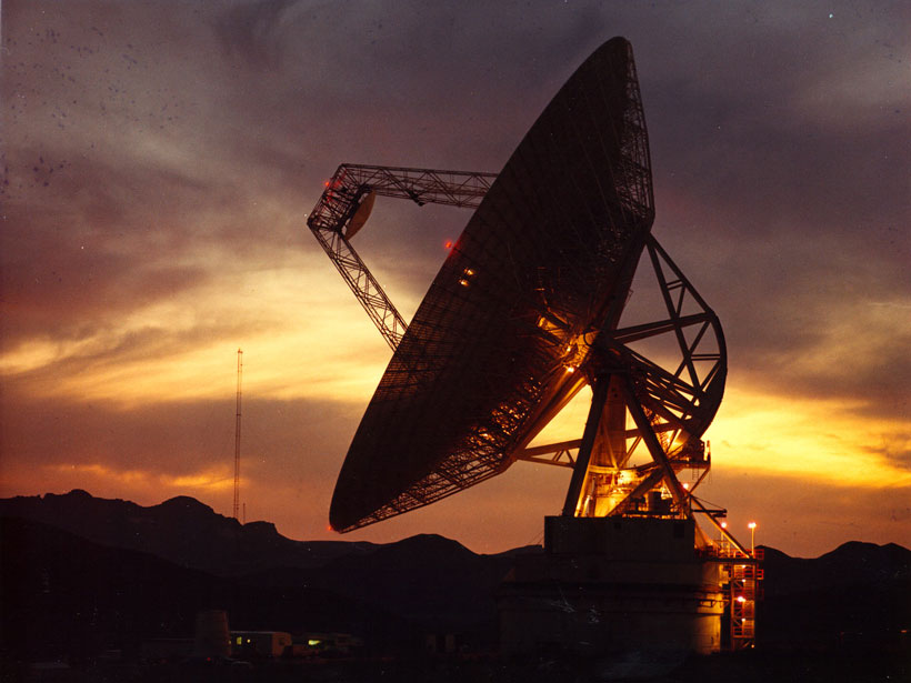
Radio telescopes reveal distant solar systems and bubbles of gas near our galaxy’s center. But they’re useful for more than just astronomy—a subset of the world’s radio telescopes could also play an important role in geophysics research. A team of scientists has now demonstrated how radio telescopes could be linked to satellites that measure ground deformation, the first step toward studying changes on Earth’s surface on a global scale.
Wanted: A Global View
“The height of Earth’s surface is changing all of the time,” said Amy Parker, a satellite radar specialist at Curtin University in Perth, Australia. These displacements occur for a myriad of reasons, some natural and some anthropogenic: earthquakes, mining, and groundwater extraction, for example.
But accurately monitoring these changes on intercontinental scales—important for determining how land movements affect calculations of sea level rise and fall, for instance—is currently impossible: Interferometric synthetic aperture radar (InSAR), which involves bouncing microwaves off Earth’s surface and measuring their travel time and phase to trace ground deformation, works only over contiguous swaths of land. (That’s because water scatters microwaves inconsistently.) InSAR is “pretty amazing,” said Parker, but it measures ground displacement only relative to an arbitrary reference like the mean value in an image. It doesn’t measure changes relative to an absolute reference frame, and it can’t be used to study global-scale processes, said Parker. “We need to tie measurements on different continents into a consistent reference frame.”
One way of doing so, Parker and her colleagues suggest, is to connect two existing networks: InSAR satellites and radio telescopes capable of very long baseline interferometry (VLBI).
Here Come the Telescopes
Astronomical observations often involve resolving fine details, like separating two objects that appear close together in the sky. Physically larger telescopes have better angular resolution, but there’s a practical limit to how large a single telescope can be.
That’s where interferometry comes in. By carefully combining the light gathered by multiple telescopes linked together by precise timing, astronomers can, in a sense, build a much larger telescope: They can achieve an angular resolution equal to that of a telescope with a diameter that’s the distance between the linked telescopes. Very long baseline interferometry refers to interferometry done over very large distances (“baselines”), even across continents. (Astronomers used VLBI to create the Event Horizon Telescope, a network of telescopes that obtained the first image of a black hole.)
When a network of VLBI telescopes accurately measures the arrival of light from a distant galaxy, researchers can compare the time stamps of the observations to determine the telescopes’ positions relative to one another. Thanks to precise timing, the distances between telescopes can be measured to within a few millimeters.
Because telescopes don’t move relative to Earth’s surface, these measurements reflect changes in the planet’s crust and can be used to trace the motion of tectonic plates, for instance. The International VLBI Service for Geodesy and Astrometry coordinates these geodetic measurements from NASA’s Goddard Space Flight Center in Greenbelt, Md. Currently, there are about 40 VLBI telescopes worldwide that can do this sort of geodetic monitoring.
Tests on Two Continents
Connecting the capabilities of InSAR satellites and geodetic VLBI telescopes would open up new observing opportunities, Parker said. “We get a connection between what the satellite is measuring and the reference frame that the telescope is measuring.”
To test the feasibility of this idea, the researchers focused on four geodetic VLBI telescopes, three in Australia and one in Sweden. They showed that the telescopes could be tied to the European Space Agency’s Sentinel-1 satellite constellation used for InSAR by simply pointing the telescopes statically toward the location of an overpassing satellite. Microwaves emitted by the satellites were readily picked up by the telescopes and reflected back, even when the telescopes didn’t track a satellite’s overpass. “It’s the easiest solution for an operator to implement, and it’s as good as steering the telescope,” said Parker.
“It’s very practical.”
These observations can be completed in only a minute or two, Parker and her colleagues showed, and they don’t require any new instruments or infrastructure. However, it might be necessary to protect telescopes’ sensitive electronics from the satellites’ relatively strong signals, the researchers found. One option is to install metallic foil—impervious to radar frequencies—around a telescope’s low-noise amplifier. Another possibility, which Parker and her team tested, was to simply point the telescope slightly away from a satellite’s position.
“The international network of Very Long Baseline Interferometry telescopes provides an existing, yet unexploited, link to unify satellite-radar measurements on a global scale,” the researchers concluded in their study, which was published in Geophysical Research Letters in November.
“It’s a really nice piece of work,” said John Gipson, a physicist at NASA Goddard Space Flight Center and an International VLBI Service for Geodesy and Astrometry team member not involved in this research. “It’s very practical.”
Parker and her colleagues are optimistic that the scientific community will see the advantages of using radio telescopes for geophysics applications. They hope to see a sizeable number of telescopes and InSAR satellites linked within the next year or two.
—Katherine Kornei (@katherinekornei), Freelance Science Journalist
Citation:
Kornei, K. (2019), More than just astronomy: Radio telescopes for geophysics, Eos, 100, https://doi.org/10.1029/2019EO137441. Published on 06 December 2019.
Text © 2019. The authors. CC BY-NC-ND 3.0
Except where otherwise noted, images are subject to copyright. Any reuse without express permission from the copyright owner is prohibited.


